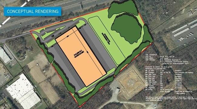
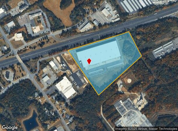
Property Record
100 Huff Rd, Mickleton, NJ 08056
Property Detail
100 Huff Rd
03-00204-0000-00034
Gloucester
Vacantlandnec
New Jersey
X
34
34015C0059F
23.71 AC
2024
Gloucester County
2025
Philadelphia
500601
Philadelphia-Camden-Wilmington, PA-NJ-DE-MD
NEARBY LISTINGS FOR SALE OR LEASE
DEMOGRAPHICS near 100 Huff Rd
1 mile
3 mile
5 mile
2024 Total Population
3,611
20,855
61,177
2029 Population
3,703
21,567
62,962
Pop Growth 2024-2029
+ 2.55%
+ 3.41%
+ 2.92%
Average Age
42
41
41
2024 Total Households
1,466
7,820
23,505
HH Growth 2024-2029
+ 2.59%
+ 3.49%
+ 2.97%
Median Household Inc
$76,295
$85,934
$92,451
Avg Household Size
2.40
2.60
2.60
2024 Avg HH Vehicles
2.00
2.00
2.00
Median Home Value
$216,046
$278,726
$269,526
Median Year Built
1961
1967
1974
Nearby Places
Map Layers
Map Styles
 Street
 Aerial
Transit
 Traffic
 Biking
Places
Listings with unknown addresses are not visible on the map
- Restaurants
- Banks
- Shops
- Fitness
- Groceries
PUBLIC TRANSPORTATION
AIRPORT
Philadelphia International
Drive
Walk
Distance
Philadelphia International
28 min
17.4 mi
Freight Ports
Broadway Terminal - Pier 5
Drive
Walk
Distance
Broadway Terminal - Pier 5
18 min
11.5 mi
SALE & LEASE HISTORY
LISTING DATE
SALE/LEASE

Sep 24, 2016
For Sale
Jun 16, 2017
For Sale
Nearby Properties
Address
Land Use
TOTAL SIZE
Lot Size
Zoning
Address
Land Use
TOTAL SIZE
Lot Size
Zoning
653.90 AC
Address
Land Use
TOTAL SIZE
Lot Size
Zoning
69.05 AC
M2
Address
Land Use
TOTAL SIZE
Lot Size
Zoning
71.49 AC
Address
Land Use
TOTAL SIZE
Lot Size
Zoning
111.06 AC
MIBP
Address
Land Use
TOTAL SIZE
Lot Size
Zoning
28 AC
IC
Address
Land Use
TOTAL SIZE
Lot Size
Zoning
47.40 AC
C2
Address
Land Use
TOTAL SIZE
Lot Size
Zoning
Address
Land Use
TOTAL SIZE
Lot Size
Zoning
53.18 AC
M2
Address
Land Use
TOTAL SIZE
Lot Size
Zoning
40.25 AC
M
Address
Land Use
TOTAL SIZE
Lot Size
Zoning
73.82 AC
M
Address
Land Use
TOTAL SIZE
Lot Size
Zoning
34.58 AC
Address
Land Use
TOTAL SIZE
Lot Size
Zoning
32.88 AC
M1
Address
Land Use
TOTAL SIZE
Lot Size
Zoning
Address
Land Use
TOTAL SIZE
Lot Size
Zoning
Address
Land Use
TOTAL SIZE
Lot Size
Zoning
Address
Land Use
TOTAL SIZE
Lot Size
Zoning
24.27 AC
M2
Address
Land Use
TOTAL SIZE
Lot Size
Zoning
994 AC
R3
Address
Land Use
TOTAL SIZE
Lot Size
Zoning
55.38 AC
M2
Address
Land Use
TOTAL SIZE
Lot Size
Zoning
111.40 AC
RRC
Address
Land Use
TOTAL SIZE
Lot Size
Zoning
36.52 AC
M1
Address
Land Use
TOTAL SIZE
Lot Size
Zoning
31 AC
M1
Address
Land Use
TOTAL SIZE
Lot Size
Zoning
302.82 AC
M2
Address
Land Use
TOTAL SIZE
Lot Size
Zoning
27.18 AC
M1
Address
Land Use
TOTAL SIZE
Lot Size
Zoning
30.76 AC
BP
Address
Land Use
TOTAL SIZE
Lot Size
Zoning
10.13 AC
Address
Land Use
TOTAL SIZE
Lot Size
Zoning
5.72 AC
R3
Address
Land Use
TOTAL SIZE
Lot Size
Zoning
5 AC
R1
Address
Land Use
TOTAL SIZE
Lot Size
Zoning
10.39 AC
RRC
Address
Land Use
TOTAL SIZE
Lot Size
Zoning
14.66 AC
M1
Address
Land Use
TOTAL SIZE
Lot Size
Zoning
18.21 AC
M1
The World's #1 Commercial Real Estate Marketplace
Connect with us
© 2026 CoStar Group
The information above has been obtained from sources believed reliable. While we do not doubt its accuracy we have not verified it and make no guarantee, warranty or representation about it. It is your responsibility to independently confirm its accuracy and completeness. Any projections, opinions, assumptions, or estimates used are for example only and do not represent the current or future performance of the property. The value of this transaction to you depends on tax and other factors which should be evaluated by your tax, financial, and legal advisors. You and your advisors should conduct a careful, independent investigation of the property to determine to your satisfaction the suitability of the property for your needs.