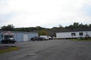
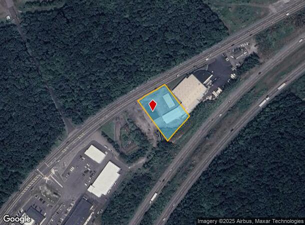
Property Record
Route 315, , PA 00315
NEARBY LISTINGS FOR SALE OR LEASE
Property Detail
Route 315
Scranton--Wilkes-Barre--Hazelton, PA
50-C-52-R10-D8-D2-1 ROUTE 00315
50-G11-00A-27C-000
Luzerne
Commercialnec
Pennsylvania
X
27c
42079C0243E
1.05 AC
2025
I-81 Corridor
2025
Philadelphia
215200
DEMOGRAPHICS near Route 315
1 Mile
3 Mile
5 Mile
2024 Total Population
1,028
23,521
103,178
2029 Population
1,012
23,336
102,864
Pop Growth 2024-2029
(1.56%)
(0.79%)
(0.30%)
Average Age
47
45
42
2024 Total Households
475
10,454
44,649
HH Growth 2024-2029
(1.68%)
(0.85%)
(0.35%)
Median Household Inc
$54,827
$62,236
$54,261
Avg Household Size
2.00
2.20
2.20
2024 Avg HH Vehicles
2.00
2.00
2.00
Median Home Value
$128,646
$140,547
$130,861
Median Year Built
1980
1958
1951
Nearby Places
- Restaurants
- Banks
- Shops
- Fitness
- Groceries
PUBLIC TRANSPORTATION
AIRPORT
Wilkes-Barre/Scranton International
DRIVE
WALK
Distance
Wilkes-Barre/Scranton International
12 min
6.9 mi
Freight Ports
Maher Terminal
DRIVE
WALK
Distance
Maher Terminal
153 min
119.6 mi
Nearby Properties
Address
Land Use
TOTAL SIZE
Lot Size
Zoning
Address
Land Use
TOTAL SIZE
Lot Size
Zoning
263.92 AC
Address
Land Use
TOTAL SIZE
Lot Size
Zoning
Address
Land Use
TOTAL SIZE
Lot Size
Zoning
50.81 AC
Address
Land Use
TOTAL SIZE
Lot Size
Zoning
225.55 AC
Address
Land Use
TOTAL SIZE
Lot Size
Zoning
132.36 AC
Address
Land Use
TOTAL SIZE
Lot Size
Zoning
46.26 AC
Address
Land Use
TOTAL SIZE
Lot Size
Zoning
44.09 AC
Address
Land Use
TOTAL SIZE
Lot Size
Zoning
80.97 AC
Address
Land Use
TOTAL SIZE
Lot Size
Zoning
Address
Land Use
TOTAL SIZE
Lot Size
Zoning
30.02 AC
Address
Land Use
TOTAL SIZE
Lot Size
Zoning
12.25 AC
Address
Land Use
TOTAL SIZE
Lot Size
Zoning
14.33 AC
Address
Land Use
TOTAL SIZE
Lot Size
Zoning
43.65 AC
Address
Land Use
TOTAL SIZE
Lot Size
Zoning
11.69 AC
Address
Land Use
TOTAL SIZE
Lot Size
Zoning
Address
Land Use
TOTAL SIZE
Lot Size
Zoning
21.24 AC
Address
Land Use
TOTAL SIZE
Lot Size
Zoning
55.45 AC
Address
Land Use
TOTAL SIZE
Lot Size
Zoning
77.69 AC
Address
Land Use
TOTAL SIZE
Lot Size
Zoning
7.74 AC
Address
Land Use
TOTAL SIZE
Lot Size
Zoning
43.01 AC
Address
Land Use
TOTAL SIZE
Lot Size
Zoning
12.60 AC
Address
Land Use
TOTAL SIZE
Lot Size
Zoning
16.96 AC
Address
Land Use
TOTAL SIZE
Lot Size
Zoning
Address
Land Use
TOTAL SIZE
Lot Size
Zoning
Address
Land Use
TOTAL SIZE
Lot Size
Zoning
13.13 AC
Address
Land Use
TOTAL SIZE
Lot Size
Zoning
Address
Land Use
TOTAL SIZE
Lot Size
Zoning
24.44 AC
Address
Land Use
TOTAL SIZE
Lot Size
Zoning
17.29 AC
The World's #1 Commercial Real Estate Marketplace
Connect with us
© 2025 CoStar Group
The information above has been obtained from sources believed reliable. While we do not doubt its accuracy we have not verified it and make no guarantee, warranty or representation about it. It is your responsibility to independently confirm its accuracy and completeness. Any projections, opinions, assumptions, or estimates used are for example only and do not represent the current or future performance of the property. The value of this transaction to you depends on tax and other factors which should be evaluated by your tax, financial, and legal advisors. You and your advisors should conduct a careful, independent investigation of the property to determine to your satisfaction the suitability of the property for your needs.