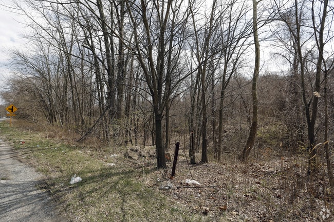
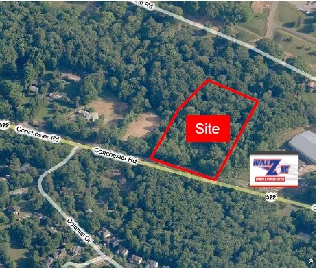
Property Record
0 Conchester Rd, Garnet Valley, PA 19060

NEARBY LISTINGS FOR SALE OR LEASE
Property Detail
0 Conchester Rd
Philadelphia-Camden-Wilmington, PA-NJ-DE-MD
Property Of James Talbot
03-00-00089-00
GRD 3AC
Vacantlandnec
Delaware
X
Pennsylvania
42045C0176F
3 AC
2024
Delaware County
2025
Philadelphia
410403
DEMOGRAPHICS near 0 Conchester Rd
1 Mile
3 Mile
5 Mile
2024 Total Population
4,460
61,125
167,423
2029 Population
4,382
60,680
167,364
Pop Growth 2024-2029
(1.75%)
(0.73%)
(0.04%)
Average Age
41
43
42
2024 Total Households
1,539
23,948
65,843
HH Growth 2024-2029
(1.75%)
(0.69%)
(0.03%)
Median Household Inc
$131,300
$94,492
$85,488
Avg Household Size
2.90
2.50
2.50
2024 Avg HH Vehicles
2.00
2.00
2.00
Median Home Value
$407,934
$336,972
$321,655
Median Year Built
1982
1975
1969
Nearby Places
Map Layers
Map Styles
 Street
 Aerial
- Restaurants
- Banks
- Shops
- Fitness
- Groceries
PUBLIC TRANSPORTATION
COMMUTER RAIL
Marcus Hook (R2 - Southeastern Pennsylvania Transportation Authority Regional Rail (SEPTA Regional Rail))
DRIVE
WALK
Distance
Marcus Hook (R2 - Southeastern Pennsylvania Transportation Authority Regional Rail (SEPTA Regional Rail))
10 min
4.4 mi
Wawa (Media/Wawa Line - SEPTA)
DRIVE
WALK
Distance
Wawa (Media/Wawa Line - SEPTA)
9 min
4.6 mi
AIRPORT
Philadelphia International
DRIVE
WALK
Distance
Philadelphia International
22 min
13.3 mi
Freight Ports
Port of Wilmington, RI
DRIVE
WALK
Distance
Port of Wilmington, RI
23 min
14.5 mi
SALE & LEASE HISTORY
LISTING DATE
SALE/LEASE

Apr 23, 2018
For Sale
Nearby Properties
Address
Land Use
TOTAL SIZE
Lot Size
Zoning
Address
Land Use
TOTAL SIZE
Lot Size
Zoning
196,366 SF
106.66 AC
Address
Land Use
TOTAL SIZE
Lot Size
Zoning
2,226 SF
25.25 AC
Address
Land Use
TOTAL SIZE
Lot Size
Zoning
111,606 SF
50 AC
Address
Land Use
TOTAL SIZE
Lot Size
Zoning
36.50 AC
Address
Land Use
TOTAL SIZE
Lot Size
Zoning
241,250 SF
2 AC
Address
Land Use
TOTAL SIZE
Lot Size
Zoning
15,880 SF
27.07 AC
Address
Land Use
TOTAL SIZE
Lot Size
Zoning
161,707 SF
56 AC
Address
Land Use
TOTAL SIZE
Lot Size
Zoning
95,760 SF
20 AC
Address
Land Use
TOTAL SIZE
Lot Size
Zoning
22,140 SF
16 AC
Address
Land Use
TOTAL SIZE
Lot Size
Zoning
151,153 SF
242.50 AC
Address
Land Use
TOTAL SIZE
Lot Size
Zoning
10,716 SF
14.34 AC
Address
Land Use
TOTAL SIZE
Lot Size
Zoning
208,352 SF
21 AC
Address
Land Use
TOTAL SIZE
Lot Size
Zoning
92,160 SF
58.23 AC
Address
Land Use
TOTAL SIZE
Lot Size
Zoning
128,467 SF
54.30 AC
Address
Land Use
TOTAL SIZE
Lot Size
Zoning
122,819 SF
21.23 AC
S
Address
Land Use
TOTAL SIZE
Lot Size
Zoning
560 SF
298.31 AC
Address
Land Use
TOTAL SIZE
Lot Size
Zoning
43,500 SF
5.22 AC
Address
Land Use
TOTAL SIZE
Lot Size
Zoning
44,200 SF
9.30 AC
Address
Land Use
TOTAL SIZE
Lot Size
Zoning
131,812 SF
20.70 AC
Address
Land Use
TOTAL SIZE
Lot Size
Zoning
173.29 AC
Address
Land Use
TOTAL SIZE
Lot Size
Zoning
166,216 SF
5.01 AC
NCAP
Address
Land Use
TOTAL SIZE
Lot Size
Zoning
162,420 SF
8 AC
Address
Land Use
TOTAL SIZE
Lot Size
Zoning
41.71 AC
Address
Land Use
TOTAL SIZE
Lot Size
Zoning
175,804 SF
Address
Land Use
TOTAL SIZE
Lot Size
Zoning
297,108 SF
5.74 AC
NCAP
Address
Land Use
TOTAL SIZE
Lot Size
Zoning
171,500 SF
12.93 AC
Address
Land Use
TOTAL SIZE
Lot Size
Zoning
23,976 SF
7.89 AC
Address
Land Use
TOTAL SIZE
Lot Size
Zoning
1,204 SF
7.39 AC
Address
Land Use
TOTAL SIZE
Lot Size
Zoning
6,524 SF
6.89 AC
Address
Land Use
TOTAL SIZE
Lot Size
Zoning
56,167 SF
4.95 AC
The World's #1 Commercial Real Estate Marketplace
Connect with us
© 2025 CoStar Group
The information above has been obtained from sources believed reliable. While we do not doubt its accuracy we have not verified it and make no guarantee, warranty or representation about it. It is your responsibility to independently confirm its accuracy and completeness. Any projections, opinions, assumptions, or estimates used are for example only and do not represent the current or future performance of the property. The value of this transaction to you depends on tax and other factors which should be evaluated by your tax, financial, and legal advisors. You and your advisors should conduct a careful, independent investigation of the property to determine to your satisfaction the suitability of the property for your needs.