Property Record
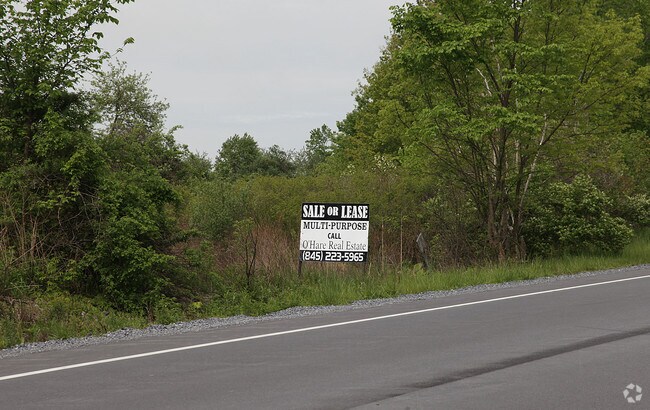
Route 55, Lagrangeville, NY 12540
NEARBY LISTINGS FOR SALE OR LEASE
-
-
View all Lagrangeville listings for sale on LoopNet.com
Property Detail
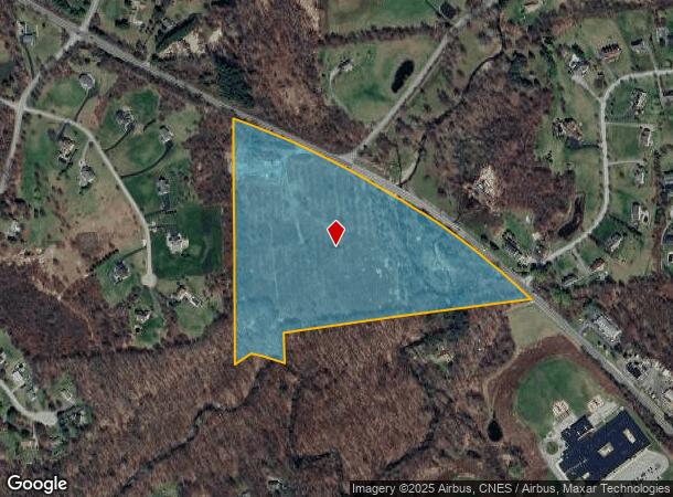
Route 55
Dutchess County-Putnam County, NY
25.2 AC (S) 1463 0615 0529 0218
135400-6660-00-206503-0000
Dutchess
Commercialacreage
New York
AE
206
36027C0411E
25.20 AC
2025
Fishkill
2024
Westchester/So Connecticut
080104
DEMOGRAPHICS near Route 55
1 Mile
3 Mile
5 Mile
2024 Total Population
1,120
8,950
29,475
2029 Population
1,111
8,931
29,476
Pop Growth 2024-2029
(0.80%)
(0.21%)
0.00%
Average Age
43
42
42
2024 Total Households
399
3,190
10,334
HH Growth 2024-2029
(1.00%)
(0.22%)
+ 0.01%
Median Household Inc
$112,500
$111,569
$115,533
Avg Household Size
2.80
2.70
2.80
2024 Avg HH Vehicles
2.00
2.00
2.00
Median Home Value
$435,484
$428,210
$419,429
Median Year Built
1976
1980
1981
Nearby Places
- Restaurants
- Banks
- Shops
- Fitness
- Groceries
PUBLIC TRANSPORTATION
AIRPORT
New York Stewart International
DRIVE
WALK
Distance
New York Stewart International
47 min
32.1 mi
Freight Ports
Port of New Haven
DRIVE
WALK
Distance
Port of New Haven
98 min
63.7 mi
Nearby Properties
Address
Land Use
TOTAL SIZE
Lot Size
Zoning
Address
Land Use
TOTAL SIZE
Lot Size
Zoning
100 SF
86.38 AC
TC
Address
Land Use
TOTAL SIZE
Lot Size
Zoning
13.98 AC
TC
Address
Land Use
TOTAL SIZE
Lot Size
Zoning
122,319 SF
23.12 AC
TCR
Address
Land Use
TOTAL SIZE
Lot Size
Zoning
10,448 SF
80.50 AC
RLD
Address
Land Use
TOTAL SIZE
Lot Size
Zoning
55,520 SF
26.30 AC
RLD
Address
Land Use
TOTAL SIZE
Lot Size
Zoning
200 SF
486.87 AC
SPR
Address
Land Use
TOTAL SIZE
Lot Size
Zoning
Address
Land Use
TOTAL SIZE
Lot Size
Zoning
Address
Land Use
TOTAL SIZE
Lot Size
Zoning
171,944 SF
10.49 AC
GB
Address
Land Use
TOTAL SIZE
Lot Size
Zoning
64,052 SF
18.57 AC
GH
Address
Land Use
TOTAL SIZE
Lot Size
Zoning
38,610 SF
14.52 AC
TCB
Address
Land Use
TOTAL SIZE
Lot Size
Zoning
Address
Land Use
TOTAL SIZE
Lot Size
Zoning
4,611 SF
388.78 AC
RA3
Address
Land Use
TOTAL SIZE
Lot Size
Zoning
6,520 SF
109.60 AC
RD10
Address
Land Use
TOTAL SIZE
Lot Size
Zoning
23,053 SF
165.05 AC
RA3
Address
Land Use
TOTAL SIZE
Lot Size
Zoning
21,925 SF
4.20 AC
GB
Address
Land Use
TOTAL SIZE
Lot Size
Zoning
2,024 SF
1.86 AC
B1
Address
Land Use
TOTAL SIZE
Lot Size
Zoning
83,570 SF
21 AC
C
Address
Land Use
TOTAL SIZE
Lot Size
Zoning
22,912 SF
14.47 AC
C
Address
Land Use
TOTAL SIZE
Lot Size
Zoning
100.30 AC
RD10
Address
Land Use
TOTAL SIZE
Lot Size
Zoning
11,472 SF
28.56 AC
TCR
Address
Land Use
TOTAL SIZE
Lot Size
Zoning
7,458 SF
246.70 AC
RLD
Address
Land Use
TOTAL SIZE
Lot Size
Zoning
Address
Land Use
TOTAL SIZE
Lot Size
Zoning
248.48 AC
R-45
Address
Land Use
TOTAL SIZE
Lot Size
Zoning
6,727 SF
8.91 AC
B1
Address
Land Use
TOTAL SIZE
Lot Size
Zoning
14,403 SF
2.81 AC
TCB
Address
Land Use
TOTAL SIZE
Lot Size
Zoning
3,521 SF
28.61 AC
TC
Address
Land Use
TOTAL SIZE
Lot Size
Zoning
22,816 SF
5.47 AC
H
Address
Land Use
TOTAL SIZE
Lot Size
Zoning
60,582 SF
15.70 AC
RLD
Address
Land Use
TOTAL SIZE
Lot Size
Zoning
17,755 SF
4.39 AC
B1
The World's #1 Commercial Real Estate Marketplace
Connect with us
© 2025 CoStar Group
The information above has been obtained from sources believed reliable. While we do not doubt its accuracy we have not verified it and make no guarantee, warranty or representation about it. It is your responsibility to independently confirm its accuracy and completeness. Any projections, opinions, assumptions, or estimates used are for example only and do not represent the current or future performance of the property. The value of this transaction to you depends on tax and other factors which should be evaluated by your tax, financial, and legal advisors. You and your advisors should conduct a careful, independent investigation of the property to determine to your satisfaction the suitability of the property for your needs.