Property Record
8S530 Oxford Ln, Naperville, IL 60565
This Property Is For Sale
NEARBY LISTINGS FOR SALE OR LEASE
Property Detail
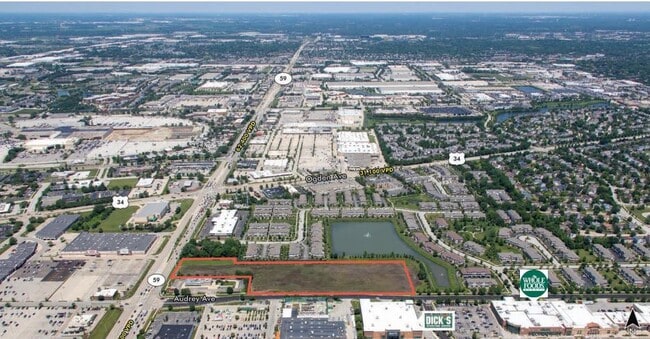
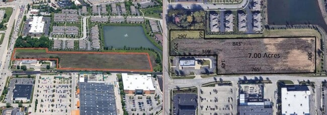
8S530 Oxford Ln
Chicago-Naperville-Elgin, IL-IN-WI
Mayfair Sub
07-27-104-087
MAYFAIR SUB PHASE 2 UNIT 2 ALL OUTLOT D
Utilities
DuPage
X
Illinois
17043C0139J
d
0
0.44 AC
2024
Western East/West Corr
846203
Chicago
DEMOGRAPHICS near 8S530 Oxford Ln
1 Mile
3 Mile
5 Mile
2024 Total Population
8,518
96,839
252,543
2029 Population
8,448
95,757
250,412
Pop Growth 2024-2029
(0.82%)
(1.12%)
(0.84%)
Average Age
36
38
38
2024 Total Households
3,230
36,088
88,438
HH Growth 2024-2029
(0.96%)
(1.16%)
(0.86%)
Median Household Inc
$111,378
$111,120
$117,061
Avg Household Size
2.60
2.60
2.80
2024 Avg HH Vehicles
2.00
2.00
2.00
Median Home Value
$354,637
$363,936
$383,493
Median Year Built
1995
1992
1991
Nearby Places
- Restaurants
- Banks
- Shops
- Fitness
- Groceries
PUBLIC TRANSPORTATION
COMMUTER RAIL
Naperville Station (Burlington Northern-Santa Fe Railway Line - Northeast Illinois Regional Commuter Railroad (Metra))
DRIVE
WALK
Distance
Naperville Station (Burlington Northern-Santa Fe Railway Line - Northeast Illinois Regional Commuter Railroad (Metra))
10 min
4.3 mi
Lisle Station (Burlington Northern-Santa Fe Railway Line - Northeast Illinois Regional Commuter Railroad (Metra))
DRIVE
WALK
Distance
Lisle Station (Burlington Northern-Santa Fe Railway Line - Northeast Illinois Regional Commuter Railroad (Metra))
12 min
5.7 mi
AIRPORT
Chicago Midway International
DRIVE
WALK
Distance
Chicago Midway International
35 min
21.9 mi
Chicago O'Hare International
DRIVE
WALK
Distance
Chicago O'Hare International
45 min
28.8 mi
Freight Ports
Port Milwaukee
DRIVE
WALK
Distance
Port Milwaukee
126 min
100.5 mi
Nearby Properties
Address
Land Use
TOTAL SIZE
Lot Size
Zoning
Address
Land Use
TOTAL SIZE
Lot Size
Zoning
6.03 AC
M
Address
Land Use
TOTAL SIZE
Lot Size
Zoning
16.28 AC
M
Address
Land Use
TOTAL SIZE
Lot Size
Zoning
166,222 SF
8.81 AC
C
Address
Land Use
TOTAL SIZE
Lot Size
Zoning
13.42 AC
Address
Land Use
TOTAL SIZE
Lot Size
Zoning
127,295 SF
1.44 AC
B
Address
Land Use
TOTAL SIZE
Lot Size
Zoning
8.53 AC
M
Address
Land Use
TOTAL SIZE
Lot Size
Zoning
22.75 AC
Address
Land Use
TOTAL SIZE
Lot Size
Zoning
Address
Land Use
TOTAL SIZE
Lot Size
Zoning
11.87 AC
Address
Land Use
TOTAL SIZE
Lot Size
Zoning
5.91 AC
Address
Land Use
TOTAL SIZE
Lot Size
Zoning
94,213 SF
1.01 AC
Address
Land Use
TOTAL SIZE
Lot Size
Zoning
3.65 AC
C
Address
Land Use
TOTAL SIZE
Lot Size
Zoning
Address
Land Use
TOTAL SIZE
Lot Size
Zoning
64,483 SF
0.52 AC
B
Address
Land Use
TOTAL SIZE
Lot Size
Zoning
7.51 AC
C
Address
Land Use
TOTAL SIZE
Lot Size
Zoning
10.65 AC
Address
Land Use
TOTAL SIZE
Lot Size
Zoning
9.20 AC
C
Address
Land Use
TOTAL SIZE
Lot Size
Zoning
1.96 AC
C
Address
Land Use
TOTAL SIZE
Lot Size
Zoning
61,639 SF
0.46 AC
Address
Land Use
TOTAL SIZE
Lot Size
Zoning
6.39 AC
M
Address
Land Use
TOTAL SIZE
Lot Size
Zoning
7.33 AC
M
Address
Land Use
TOTAL SIZE
Lot Size
Zoning
61,533 SF
0.32 AC
Address
Land Use
TOTAL SIZE
Lot Size
Zoning
12.53 AC
C
Address
Land Use
TOTAL SIZE
Lot Size
Zoning
43,466 SF
1.31 AC
B
Address
Land Use
TOTAL SIZE
Lot Size
Zoning
72,141 SF
12.13 AC
Address
Land Use
TOTAL SIZE
Lot Size
Zoning
Address
Land Use
TOTAL SIZE
Lot Size
Zoning
Address
Land Use
TOTAL SIZE
Lot Size
Zoning
85,975 SF
8.84 AC
C
Address
Land Use
TOTAL SIZE
Lot Size
Zoning
3.42 AC
C
Address
Land Use
TOTAL SIZE
Lot Size
Zoning
27,984 SF
0.48 AC
C
The World's #1 Commercial Real Estate Marketplace
Connect with us
© 2025 CoStar Group
The information above has been obtained from sources believed reliable. While we do not doubt its accuracy we have not verified it and make no guarantee, warranty or representation about it. It is your responsibility to independently confirm its accuracy and completeness. Any projections, opinions, assumptions, or estimates used are for example only and do not represent the current or future performance of the property. The value of this transaction to you depends on tax and other factors which should be evaluated by your tax, financial, and legal advisors. You and your advisors should conduct a careful, independent investigation of the property to determine to your satisfaction the suitability of the property for your needs.