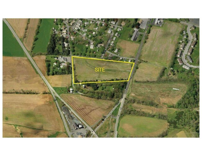
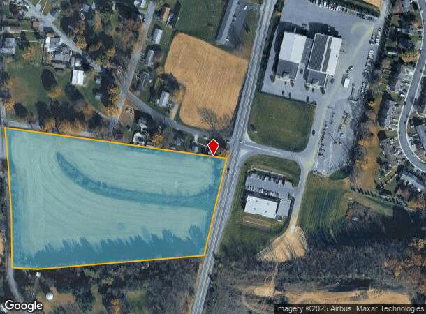
Property Record
Ws Lebanon Rd, Lebanon, PA 17042
NEARBY LISTINGS FOR SALE OR LEASE
Property Detail
Ws Lebanon Rd
34-2334626-345677-0000
CONTROL #38056162
Agriculturalland
Lebanon
X
Pennsylvania
42075C0265E
10.27 AC
2025
Lebanon
2025
Philadelphia
000200
Lebanon, PA
DEMOGRAPHICS near Ws Lebanon Rd
1 Mile
3 Mile
5 Mile
2024 Total Population
1,926
10,019
54,469
2029 Population
1,934
10,052
54,945
Pop Growth 2024-2029
+ 0.42%
+ 0.33%
+ 0.87%
Average Age
51
49
42
2024 Total Households
851
4,266
21,558
HH Growth 2024-2029
+ 0.24%
+ 0.16%
+ 0.83%
Median Household Inc
$97,655
$95,146
$67,564
Avg Household Size
2.20
2.30
2.40
2024 Avg HH Vehicles
2.00
2.00
2.00
Median Home Value
$297,339
$286,255
$196,994
Median Year Built
1979
1976
1961
Nearby Places
Map Layers
Map Styles
 Street
 Aerial
- Restaurants
- Banks
- Shops
- Fitness
- Groceries
PUBLIC TRANSPORTATION
AIRPORT
Harrisburg International
DRIVE
WALK
Distance
Harrisburg International
34 min
26.5 mi
Freight Ports
Port of Wilmington, RI
DRIVE
WALK
Distance
Port of Wilmington, RI
106 min
78.5 mi
SALE & LEASE HISTORY
LISTING DATE
SALE/LEASE

Sep 24, 2016
For Sale
Nearby Properties
Address
Land Use
TOTAL SIZE
Lot Size
Zoning
Address
Land Use
TOTAL SIZE
Lot Size
Zoning
73,544 SF
6.59 AC
Address
Land Use
TOTAL SIZE
Lot Size
Zoning
30,949 SF
56.72 AC
Address
Land Use
TOTAL SIZE
Lot Size
Zoning
153,171 SF
55.65 AC
Address
Land Use
TOTAL SIZE
Lot Size
Zoning
3,534 SF
3.32 AC
Address
Land Use
TOTAL SIZE
Lot Size
Zoning
3,962 SF
14.50 AC
Address
Land Use
TOTAL SIZE
Lot Size
Zoning
449 SF
2.35 AC
Address
Land Use
TOTAL SIZE
Lot Size
Zoning
21,576 SF
2.18 AC
Address
Land Use
TOTAL SIZE
Lot Size
Zoning
51,128 SF
2.23 AC
Address
Land Use
TOTAL SIZE
Lot Size
Zoning
116,255 SF
15.33 AC
Address
Land Use
TOTAL SIZE
Lot Size
Zoning
3,474 SF
1,105 AC
Address
Land Use
TOTAL SIZE
Lot Size
Zoning
55,574 SF
5.66 AC
Address
Land Use
TOTAL SIZE
Lot Size
Zoning
132,139 SF
26.20 AC
Address
Land Use
TOTAL SIZE
Lot Size
Zoning
24,797 SF
5.94 AC
Address
Land Use
TOTAL SIZE
Lot Size
Zoning
86,003 SF
22.70 AC
Address
Land Use
TOTAL SIZE
Lot Size
Zoning
24,779 SF
4.21 AC
Address
Land Use
TOTAL SIZE
Lot Size
Zoning
123,719 SF
71.37 AC
Address
Land Use
TOTAL SIZE
Lot Size
Zoning
12,704 SF
10.10 AC
Address
Land Use
TOTAL SIZE
Lot Size
Zoning
39,896 SF
8.27 AC
Address
Land Use
TOTAL SIZE
Lot Size
Zoning
40,586 SF
6.94 AC
Address
Land Use
TOTAL SIZE
Lot Size
Zoning
806,359 SF
54.71 AC
Address
Land Use
TOTAL SIZE
Lot Size
Zoning
7,538 SF
6.18 AC
Address
Land Use
TOTAL SIZE
Lot Size
Zoning
848 SF
4.82 AC
Address
Land Use
TOTAL SIZE
Lot Size
Zoning
26,910 SF
5.82 AC
Address
Land Use
TOTAL SIZE
Lot Size
Zoning
44,200 SF
193.51 AC
Address
Land Use
TOTAL SIZE
Lot Size
Zoning
47,742 SF
2.65 AC
Address
Land Use
TOTAL SIZE
Lot Size
Zoning
21,850 SF
5.77 AC
Address
Land Use
TOTAL SIZE
Lot Size
Zoning
20,108 SF
2.44 AC
Address
Land Use
TOTAL SIZE
Lot Size
Zoning
37,887 SF
17.17 AC
Address
Land Use
TOTAL SIZE
Lot Size
Zoning
20,829 SF
6.54 AC
Address
Land Use
TOTAL SIZE
Lot Size
Zoning
53,370 SF
4.01 AC
The World's #1 Commercial Real Estate Marketplace
Connect with us
© 2025 CoStar Group
The information above has been obtained from sources believed reliable. While we do not doubt its accuracy we have not verified it and make no guarantee, warranty or representation about it. It is your responsibility to independently confirm its accuracy and completeness. Any projections, opinions, assumptions, or estimates used are for example only and do not represent the current or future performance of the property. The value of this transaction to you depends on tax and other factors which should be evaluated by your tax, financial, and legal advisors. You and your advisors should conduct a careful, independent investigation of the property to determine to your satisfaction the suitability of the property for your needs.