Property Record
1245 Highway 77, Bridgeton, NJ 08302
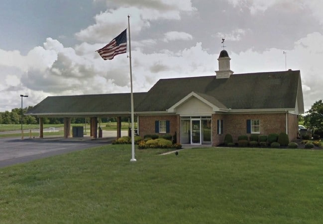

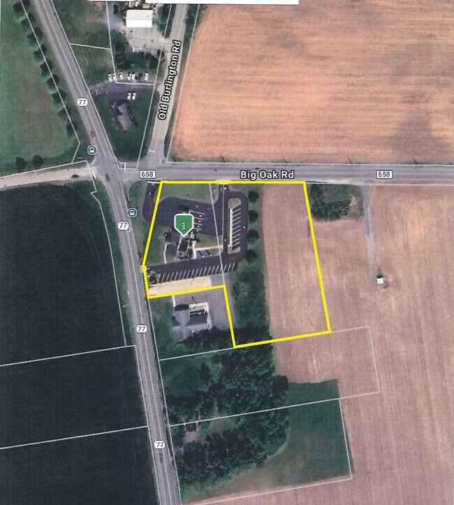
Property Detail
1245 Highway 77
13-01202-0000-00005
Cumberland
Financialbuilding
New Jersey
B1
5
B and X Area of moderate flood hazard, usually the area between the limits of the 100-year and 500-year floods.
1.21 AC
2025
Vineland/Bridgeton
2026
Philadelphia
010701
Vineland, NJ
NEARBY LISTINGS FOR SALE OR LEASE
DEMOGRAPHICS near 1245 Highway 77
1 mile
3 mile
5 mile
2025 Total Population
495
8,801
39,990
2030 Population
516
9,072
40,834
Pop Growth 2025-2030
+ 4.24%
+ 3.08%
+ 2.11%
Average Age
36
40
37
2025 Total Households
180
3,220
12,975
HH Growth 2025-2030
+ 4.44%
+ 3.01%
+ 2.24%
Median Household Inc
$51,875
$74,534
$63,620
Avg Household Size
2.80
2.70
2.90
2025 Avg HH Vehicles
1.00
2.00
2.00
Median Home Value
$261,904
$271,470
$231,299
Median Year Built
1974
1974
1966
Nearby Places
Map Layers
Map Styles
 Street
 Aerial
Layers
 Traffic
 Biking
Places
Listings with unknown addresses are not visible on the map
- Restaurants
- Banks
- Shops
- Fitness
- Groceries
PUBLIC TRANSPORTATION
AIRPORT
Philadelphia International
Drive
Walk
Distance
Philadelphia International
61 min
37.3 mi
Atlantic City International
Drive
Walk
Distance
Atlantic City International
79 min
40.0 mi
Freight Ports
Port of Wilmington, RI
Drive
Walk
Distance
Port of Wilmington, RI
47 min
33.1 mi
SALE & LEASE HISTORY
LISTING DATE
SALE/LEASE

Jul 31, 2019
For Sale
Jan 28, 2025
For Sale
Aug 16, 2022
For Lease
Aug 16, 2022
For Sale
Nearby Properties
Address
Land Use
TOTAL SIZE
Lot Size
Zoning
Address
Land Use
TOTAL SIZE
Lot Size
Zoning
140.15 AC
R1
Address
Land Use
TOTAL SIZE
Lot Size
Zoning
Address
Land Use
TOTAL SIZE
Lot Size
Zoning
16.23 AC
Address
Land Use
TOTAL SIZE
Lot Size
Zoning
29.17 AC
B2
Address
Land Use
TOTAL SIZE
Lot Size
Zoning
Address
Land Use
TOTAL SIZE
Lot Size
Zoning
32.89 AC
GI
Address
Land Use
TOTAL SIZE
Lot Size
Zoning
9.64 AC
P
Address
Land Use
TOTAL SIZE
Lot Size
Zoning
32.57 AC
GI
Address
Land Use
TOTAL SIZE
Lot Size
Zoning
Address
Land Use
TOTAL SIZE
Lot Size
Zoning
23.50 AC
P
Address
Land Use
TOTAL SIZE
Lot Size
Zoning
22 AC
B2
Address
Land Use
TOTAL SIZE
Lot Size
Zoning
37.12 AC
A
Address
Land Use
TOTAL SIZE
Lot Size
Zoning
13.67 AC
B2
Address
Land Use
TOTAL SIZE
Lot Size
Zoning
13.94 AC
Address
Land Use
TOTAL SIZE
Lot Size
Zoning
13.46 AC
B-2
Address
Land Use
TOTAL SIZE
Lot Size
Zoning
9.17 AC
R2
Address
Land Use
TOTAL SIZE
Lot Size
Zoning
4.20 AC
R2
Address
Land Use
TOTAL SIZE
Lot Size
Zoning
5.38 AC
R2
Address
Land Use
TOTAL SIZE
Lot Size
Zoning
13.21 AC
B2
Address
Land Use
TOTAL SIZE
Lot Size
Zoning
116.91 AC
GI
Address
Land Use
TOTAL SIZE
Lot Size
Zoning
69.36 AC
Address
Land Use
TOTAL SIZE
Lot Size
Zoning
0.83 AC
GI
Address
Land Use
TOTAL SIZE
Lot Size
Zoning
26.08 AC
GI
Address
Land Use
TOTAL SIZE
Lot Size
Zoning
6.73 AC
P
Address
Land Use
TOTAL SIZE
Lot Size
Zoning
48.66 AC
P
Address
Land Use
TOTAL SIZE
Lot Size
Zoning
5,324 SF
3.94 AC
B2
Address
Land Use
TOTAL SIZE
Lot Size
Zoning
2,019 SF
2.43 AC
B2
Address
Land Use
TOTAL SIZE
Lot Size
Zoning
9.11 AC
P
Address
Land Use
TOTAL SIZE
Lot Size
Zoning
14.63 AC
GI
Address
Land Use
TOTAL SIZE
Lot Size
Zoning
105.66 AC
89
The World's #1 Commercial Real Estate Marketplace
Connect with us
© 2026 CoStar Group
The information above has been obtained from sources believed reliable. While we do not doubt its accuracy we have not verified it and make no guarantee, warranty or representation about it. It is your responsibility to independently confirm its accuracy and completeness. Any projections, opinions, assumptions, or estimates used are for example only and do not represent the current or future performance of the property. The value of this transaction to you depends on tax and other factors which should be evaluated by your tax, financial, and legal advisors. You and your advisors should conduct a careful, independent investigation of the property to determine to your satisfaction the suitability of the property for your needs.