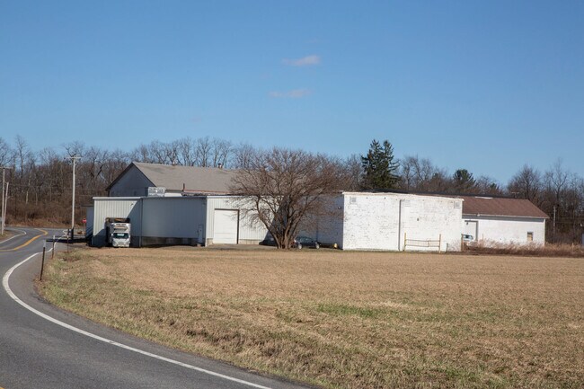
Property Record
Route 9, , NY

Save to a Folder
{{folder.Name}}
{{folder.ListingIds.length}} Properties
{{folder.ListingIds.length}} Property
Create a New Folder
Property Detail
Route 9
Hudson, NY
COLUMBIA
103000-191-004-0002-035-000-0000
New York
Grainelevator
35.000
07 - MIXED
4.39 AC
2025
Columbia County
2025
Albany/Schenectady/Troy
001900
NEARBY LISTINGS FOR SALE OR LEASE
-
-
View all listings for sale on LoopNet.com
DEMOGRAPHICS near Route 9
1 mile
3 mile
5 mile
2025 Total Population
522
3,861
11,022
2030 Population
506
3,817
10,912
Pop Growth 2025-2030
(3.07%)
(1.14%)
(1.00%)
Average Age
43
44
44
2025 Total Households
196
1,529
4,388
HH Growth 2025-2030
(3.06%)
(1.24%)
(1.16%)
Median Household Inc
$89,999
$97,783
$98,299
Avg Household Size
2.60
2.40
2.40
2025 Avg HH Vehicles
2.00
2.00
2.00
Median Home Value
$459,374
$446,861
$446,101
Median Year Built
1971
1972
1971
Nearby Places
Map Layers
Map Styles
 Street
 Aerial
Layers
 Traffic
 Biking
Places
Listings with unknown addresses are not visible on the map
- Restaurants
- Banks
- Shops
- Fitness
- Groceries
SALE & LEASE HISTORY
LISTING DATE
SALE/LEASE

Jun 06, 2023
For Sale
Aug 20, 2021
For Sale
Nearby Properties
Address
Land Use
TOTAL SIZE
Lot Size
Zoning
Address
Land Use
TOTAL SIZE
Lot Size
Zoning
108,009 SF
54.40 AC
I
Address
Land Use
TOTAL SIZE
Lot Size
Zoning
2,634 SF
108.40 AC
RA
Address
Land Use
TOTAL SIZE
Lot Size
Zoning
2,872 SF
173.64 AC
ABD
Address
Land Use
TOTAL SIZE
Lot Size
Zoning
39,538 SF
230.15 AC
07 - MIXED
Address
Land Use
TOTAL SIZE
Lot Size
Zoning
3,744 SF
3.25 AC
07 - MIXED
Address
Land Use
TOTAL SIZE
Lot Size
Zoning
57,667 SF
15.30 AC
07 - MIXED
Address
Land Use
TOTAL SIZE
Lot Size
Zoning
2,816 SF
133.58 AC
ABD
Address
Land Use
TOTAL SIZE
Lot Size
Zoning
3,760 SF
114.50 AC
ABD
Address
Land Use
TOTAL SIZE
Lot Size
Zoning
800 SF
79.20 AC
RA
Address
Land Use
TOTAL SIZE
Lot Size
Zoning
3,072 SF
67.14 AC
ABD
Address
Land Use
TOTAL SIZE
Lot Size
Zoning
88.87 AC
ABD
Address
Land Use
TOTAL SIZE
Lot Size
Zoning
6,180 SF
31.60 AC
RA
Address
Land Use
TOTAL SIZE
Lot Size
Zoning
1,320 SF
109.98 AC
ABD
Address
Land Use
TOTAL SIZE
Lot Size
Zoning
3,210 SF
125.34 AC
ABD
Address
Land Use
TOTAL SIZE
Lot Size
Zoning
3,430 SF
112 AC
RA
Address
Land Use
TOTAL SIZE
Lot Size
Zoning
7,974 SF
2.20 AC
07 - MIXED
Address
Land Use
TOTAL SIZE
Lot Size
Zoning
6,544 SF
47.77 AC
ABD
Address
Land Use
TOTAL SIZE
Lot Size
Zoning
600 SF
93.81 AC
A3A
Address
Land Use
TOTAL SIZE
Lot Size
Zoning
2,805 SF
90 AC
ABD
Address
Land Use
TOTAL SIZE
Lot Size
Zoning
3,040 SF
86.54 AC
ABD
Address
Land Use
TOTAL SIZE
Lot Size
Zoning
92.13 AC
ABD
Address
Land Use
TOTAL SIZE
Lot Size
Zoning
2,116 SF
66.20 AC
RJCRA
Address
Land Use
TOTAL SIZE
Lot Size
Zoning
4,350 SF
5.70 AC
07 - MIXED
Address
Land Use
TOTAL SIZE
Lot Size
Zoning
91.34 AC
ABD
Address
Land Use
TOTAL SIZE
Lot Size
Zoning
924 SF
8.63 AC
RA
Address
Land Use
TOTAL SIZE
Lot Size
Zoning
9,600 SF
37.90 AC
07 - MIXED
Address
Land Use
TOTAL SIZE
Lot Size
Zoning
4,148 SF
7 AC
07 - MIXED
Address
Land Use
TOTAL SIZE
Lot Size
Zoning
82.06 AC
ABD
Address
Land Use
TOTAL SIZE
Lot Size
Zoning
3,377 SF
4.83 AC
RD3
Address
Land Use
TOTAL SIZE
Lot Size
Zoning
7,126 SF
6.99 AC
B1
The World's #1 Commercial Real Estate Marketplace
Connect with us
© 2026 CoStar Group
The information above has been obtained from sources believed reliable. While we do not doubt its accuracy we have not verified it and make no guarantee, warranty or representation about it. It is your responsibility to independently confirm its accuracy and completeness. Any projections, opinions, assumptions, or estimates used are for example only and do not represent the current or future performance of the property. The value of this transaction to you depends on tax and other factors which should be evaluated by your tax, financial, and legal advisors. You and your advisors should conduct a careful, independent investigation of the property to determine to your satisfaction the suitability of the property for your needs.