Property Record
Route 9G, Red Hook, NY 12571

NEARBY LISTINGS FOR SALE OR LEASE
-
-
View all Red Hook listings for sale on LoopNet.com
Property Detail
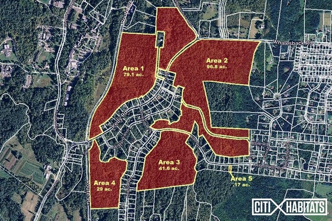
Route 9G
Dutchess County-Putnam County, NY
246.63 AC (C) 1822 0095 1086 0625
134889-6173-00-847544-0000
Dutchess
Recreationalacreage
New York
AE
847
36027C0019E
245.02 AC
2020
Fishkill
2024
Westchester/So Connecticut
150005
DEMOGRAPHICS near Route 9G
1 Mile
3 Mile
5 Mile
2024 Total Population
1,262
8,078
23,226
2029 Population
1,260
8,069
23,194
Pop Growth 2024-2029
(0.16%)
(0.11%)
(0.14%)
Average Age
42
43
44
2024 Total Households
434
3,208
9,605
HH Growth 2024-2029
0.00%
(0.19%)
(0.16%)
Median Household Inc
$124,815
$97,509
$83,921
Avg Household Size
2.60
2.40
2.30
2024 Avg HH Vehicles
2.00
2.00
2.00
Median Home Value
$449,358
$391,121
$347,827
Median Year Built
1971
1968
1967
Nearby Places
Map Layers
Map Styles
 Street
 Aerial
- Restaurants
- Banks
- Shops
- Fitness
- Groceries
PUBLIC TRANSPORTATION
COMMUTER RAIL
Rhinecliff Amtrak Station (Adirondack - Amtrak, Empire Service - Amtrak, Ethan Allen Express - Amtrak, Lake Shore Limited - Amtrak, Maple Leaf - Amtrak)
DRIVE
WALK
Distance
Rhinecliff Amtrak Station (Adirondack - Amtrak, Empire Service - Amtrak, Ethan Allen Express - Amtrak, Lake Shore Limited - Amtrak, Maple Leaf - Amtrak)
16 min
9.1 mi
Rhinecliff (Toronto - New York - VIA Rail)
DRIVE
WALK
Distance
Rhinecliff (Toronto - New York - VIA Rail)
16 min
9.1 mi
Freight Ports
Albany, NY Port
DRIVE
WALK
Distance
Albany, NY Port
65 min
47.1 mi
SALE & LEASE HISTORY
LISTING DATE
SALE/LEASE

Jul 21, 2017
For Sale
Nearby Properties
Address
Land Use
TOTAL SIZE
Lot Size
Zoning
Address
Land Use
TOTAL SIZE
Lot Size
Zoning
2,688 SF
301.70 AC
I
Address
Land Use
TOTAL SIZE
Lot Size
Zoning
105,815 SF
91.70 AC
I
Address
Land Use
TOTAL SIZE
Lot Size
Zoning
108,250 SF
16.40 AC
I
Address
Land Use
TOTAL SIZE
Lot Size
Zoning
52,880 SF
260.28 AC
I
Address
Land Use
TOTAL SIZE
Lot Size
Zoning
10 AC
R-20
Address
Land Use
TOTAL SIZE
Lot Size
Zoning
81,289 SF
115.30 AC
I
Address
Land Use
TOTAL SIZE
Lot Size
Zoning
78.11 AC
WC
Address
Land Use
TOTAL SIZE
Lot Size
Zoning
50,180 SF
14.18 AC
TND-CC
Address
Land Use
TOTAL SIZE
Lot Size
Zoning
7,994 SF
13.70 AC
23
Address
Land Use
TOTAL SIZE
Lot Size
Zoning
108,009 SF
54.40 AC
I
Address
Land Use
TOTAL SIZE
Lot Size
Zoning
1,875 SF
5.73 AC
R1.5
Address
Land Use
TOTAL SIZE
Lot Size
Zoning
2.55 AC
NMU
Address
Land Use
TOTAL SIZE
Lot Size
Zoning
27,360 SF
2.42 AC
NMU
Address
Land Use
TOTAL SIZE
Lot Size
Zoning
4,788 SF
1.62 AC
R1.5
Address
Land Use
TOTAL SIZE
Lot Size
Zoning
16.58 AC
R-20
Address
Land Use
TOTAL SIZE
Lot Size
Zoning
21.70 AC
LC
Address
Land Use
TOTAL SIZE
Lot Size
Zoning
5,617 SF
228.26 AC
ABD
Address
Land Use
TOTAL SIZE
Lot Size
Zoning
11,580 SF
4.09 AC
M
Address
Land Use
TOTAL SIZE
Lot Size
Zoning
5,225 SF
432.29 AC
RD5
Address
Land Use
TOTAL SIZE
Lot Size
Zoning
5,664 SF
5.30 AC
WC
Address
Land Use
TOTAL SIZE
Lot Size
Zoning
3,200 SF
142.47 AC
ABD
Address
Land Use
TOTAL SIZE
Lot Size
Zoning
14,549 SF
1.10 AC
GB
Address
Land Use
TOTAL SIZE
Lot Size
Zoning
5,377 SF
11.14 AC
R-10
Address
Land Use
TOTAL SIZE
Lot Size
Zoning
6,695 SF
77.81 AC
RD3
Address
Land Use
TOTAL SIZE
Lot Size
Zoning
36,941 SF
13.29 AC
TND-CC
Address
Land Use
TOTAL SIZE
Lot Size
Zoning
8,404 SF
161.07 AC
ABD
Address
Land Use
TOTAL SIZE
Lot Size
Zoning
27,830 SF
1.33 AC
LIB
Address
Land Use
TOTAL SIZE
Lot Size
Zoning
30,180 SF
6.41 AC
TND-CC
Address
Land Use
TOTAL SIZE
Lot Size
Zoning
2.55 AC
R3A
Address
Land Use
TOTAL SIZE
Lot Size
Zoning
2,816 SF
133.58 AC
ABD
The World's #1 Commercial Real Estate Marketplace
Connect with us
© 2025 CoStar Group
The information above has been obtained from sources believed reliable. While we do not doubt its accuracy we have not verified it and make no guarantee, warranty or representation about it. It is your responsibility to independently confirm its accuracy and completeness. Any projections, opinions, assumptions, or estimates used are for example only and do not represent the current or future performance of the property. The value of this transaction to you depends on tax and other factors which should be evaluated by your tax, financial, and legal advisors. You and your advisors should conduct a careful, independent investigation of the property to determine to your satisfaction the suitability of the property for your needs.