Property Record
Route 93, Hazleton, PA 18202


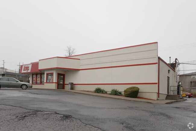
Property Detail
Route 93
Scranton--Wilkes-Barre, PA
400 SUSQUEHANNA BLVD
63-T7S2-00B-009-000
LUZERNE
Restaurantbuilding
Pennsylvania
B and X Area of moderate flood hazard, usually the area between the limits of the 100-year and 500-year floods.
9
2025
0.89 AC
2026
I-81 Corridor
217900
Philadelphia
2,640 SF
NEARBY LISTINGS FOR SALE OR LEASE
DEMOGRAPHICS near Route 93
1 mile
3 mile
5 mile
2025 Total Population
3,031
41,246
53,913
2030 Population
3,106
41,486
54,216
Pop Growth 2025-2030
+ 2.47%
+ 0.58%
+ 0.56%
Average Age
41
39
40
2025 Total Households
1,182
15,346
20,596
HH Growth 2025-2030
+ 2.37%
+ 0.61%
+ 0.58%
Median Household Inc
$50,714
$45,577
$50,758
Avg Household Size
2.50
2.60
2.50
2025 Avg HH Vehicles
2.00
1.00
2.00
Median Home Value
$169,216
$167,990
$186,614
Median Year Built
1962
1954
1957
Nearby Places
Map Layers
Map Styles
 Street
 Aerial
Layers
 Traffic
 Biking
Places
Listings with unknown addresses are not visible on the map
- Restaurants
- Banks
- Shops
- Fitness
- Groceries
PUBLIC TRANSPORTATION
AIRPORT
Wilkes-Barre/Scranton International
Drive
Walk
Distance
Wilkes-Barre/Scranton International
47 min
34.6 mi
Freight Ports
Port of Philadelphia
Drive
Walk
Distance
Port of Philadelphia
133 min
100.7 mi
SALE & LEASE HISTORY
LISTING DATE
SALE/LEASE

Aug 18, 2020
For Sale
Nearby Properties
Address
Land Use
TOTAL SIZE
Lot Size
Zoning
Address
Land Use
TOTAL SIZE
Lot Size
Zoning
63.03 AC
Address
Land Use
TOTAL SIZE
Lot Size
Zoning
422,990 SF
30.99 AC
Address
Land Use
TOTAL SIZE
Lot Size
Zoning
8,106 SF
75.45 AC
Address
Land Use
TOTAL SIZE
Lot Size
Zoning
707,060 SF
48.94 AC
Address
Land Use
TOTAL SIZE
Lot Size
Zoning
Address
Land Use
TOTAL SIZE
Lot Size
Zoning
48.47 AC
Address
Land Use
TOTAL SIZE
Lot Size
Zoning
73.81 AC
Address
Land Use
TOTAL SIZE
Lot Size
Zoning
21.03 AC
Address
Land Use
TOTAL SIZE
Lot Size
Zoning
16.35 AC
Address
Land Use
TOTAL SIZE
Lot Size
Zoning
574,667 SF
61.33 AC
Address
Land Use
TOTAL SIZE
Lot Size
Zoning
25.44 AC
Address
Land Use
TOTAL SIZE
Lot Size
Zoning
17.47 AC
Address
Land Use
TOTAL SIZE
Lot Size
Zoning
13,737 SF
529.84 AC
Address
Land Use
TOTAL SIZE
Lot Size
Zoning
33.38 AC
Address
Land Use
TOTAL SIZE
Lot Size
Zoning
184,900 SF
10.20 AC
Address
Land Use
TOTAL SIZE
Lot Size
Zoning
240,000 SF
19.48 AC
Address
Land Use
TOTAL SIZE
Lot Size
Zoning
16.98 AC
Address
Land Use
TOTAL SIZE
Lot Size
Zoning
9.14 AC
Address
Land Use
TOTAL SIZE
Lot Size
Zoning
17.22 AC
Address
Land Use
TOTAL SIZE
Lot Size
Zoning
126,434 SF
8.29 AC
Address
Land Use
TOTAL SIZE
Lot Size
Zoning
9.67 AC
Address
Land Use
TOTAL SIZE
Lot Size
Zoning
155,725 SF
19.82 AC
Address
Land Use
TOTAL SIZE
Lot Size
Zoning
33.73 AC
Address
Land Use
TOTAL SIZE
Lot Size
Zoning
131,082 SF
10.83 AC
Address
Land Use
TOTAL SIZE
Lot Size
Zoning
207,480 SF
24.89 AC
Address
Land Use
TOTAL SIZE
Lot Size
Zoning
13,170 SF
17 AC
Address
Land Use
TOTAL SIZE
Lot Size
Zoning
12.21 AC
Address
Land Use
TOTAL SIZE
Lot Size
Zoning
13.70 AC
Address
Land Use
TOTAL SIZE
Lot Size
Zoning
7.24 AC
Address
Land Use
TOTAL SIZE
Lot Size
Zoning
98.52 AC
The World's #1 Commercial Real Estate Marketplace
Connect with us
© 2026 CoStar Group
The information above has been obtained from sources believed reliable. While we do not doubt its accuracy we have not verified it and make no guarantee, warranty or representation about it. It is your responsibility to independently confirm its accuracy and completeness. Any projections, opinions, assumptions, or estimates used are for example only and do not represent the current or future performance of the property. The value of this transaction to you depends on tax and other factors which should be evaluated by your tax, financial, and legal advisors. You and your advisors should conduct a careful, independent investigation of the property to determine to your satisfaction the suitability of the property for your needs.