Property Record
Rt 17, Paramus, NJ 07652
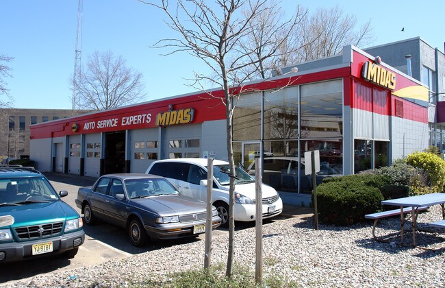

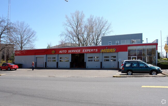
Property Detail
Rt 17
46-05202-0000-00001
64XIRR 5.7LT
Commercialnec
BERGEN
BG
New Jersey
C and X Area of minimal flood hazard, usually depicted on FIRMs as above the 500-year flood level.
1
2024
0.33 AC
2025
Route 4/17
042400
Northern New Jersey
3,300 SF
New York-Jersey City-White Plains, NY-NJ
NEARBY LISTINGS FOR SALE OR LEASE
DEMOGRAPHICS near Rt 17
1 mile
3 mile
5 mile
2025 Total Population
6,638
113,783
423,656
2030 Population
6,905
117,268
435,056
Pop Growth 2025-2030
+ 4.02%
+ 3.06%
+ 2.69%
Average Age
45
43
42
2025 Total Households
1,993
38,268
149,238
HH Growth 2025-2030
+ 4.11%
+ 3.07%
+ 2.74%
Median Household Inc
$159,425
$154,024
$121,957
Avg Household Size
3.00
2.90
2.70
2025 Avg HH Vehicles
2.00
2.00
2.00
Median Home Value
$781,485
$730,890
$644,039
Median Year Built
1957
1956
1955
Nearby Places
Map Layers
Map Styles
 Street
 Aerial
Transit
 Traffic
 Biking
Places
Listings with unknown addresses are not visible on the map
- Restaurants
- Banks
- Shops
- Fitness
- Groceries
Nearby Properties
Address
Land Use
TOTAL SIZE
Lot Size
Zoning
Address
Land Use
TOTAL SIZE
Lot Size
Zoning
Address
Land Use
TOTAL SIZE
Lot Size
Zoning
1,267 SF
0.14 AC
BML
Address
Land Use
TOTAL SIZE
Lot Size
Zoning
45,191 SF
3.11 AC
BL
Address
Land Use
TOTAL SIZE
Lot Size
Zoning
988,414 SF
34.89 AC
BG
Address
Land Use
TOTAL SIZE
Lot Size
Zoning
466,866 SF
154.93 AC
R150
Address
Land Use
TOTAL SIZE
Lot Size
Zoning
15.57 AC
H
Address
Land Use
TOTAL SIZE
Lot Size
Zoning
62.88 AC
R100
Address
Land Use
TOTAL SIZE
Lot Size
Zoning
378,400 SF
39.30 AC
BML
Address
Land Use
TOTAL SIZE
Lot Size
Zoning
102,070 SF
29.70 AC
BL
Address
Land Use
TOTAL SIZE
Lot Size
Zoning
7,060 SF
115.84 AC
HP
Address
Land Use
TOTAL SIZE
Lot Size
Zoning
394,039 SF
24.31 AC
BG
Address
Land Use
TOTAL SIZE
Lot Size
Zoning
164,588 SF
14.60 AC
BG
Address
Land Use
TOTAL SIZE
Lot Size
Zoning
250,833 SF
13.49 AC
BG
Address
Land Use
TOTAL SIZE
Lot Size
Zoning
341,076 SF
40.02 AC
R100
Address
Land Use
TOTAL SIZE
Lot Size
Zoning
259,273 SF
19.77 AC
BIL
Address
Land Use
TOTAL SIZE
Lot Size
Zoning
59 AC
AA
Address
Land Use
TOTAL SIZE
Lot Size
Zoning
12,268 SF
98 AC
CR
Address
Land Use
TOTAL SIZE
Lot Size
Zoning
23,572 SF
98.75 AC
CR
Address
Land Use
TOTAL SIZE
Lot Size
Zoning
242,048 SF
25.40 AC
BLL
Address
Land Use
TOTAL SIZE
Lot Size
Zoning
9.96 AC
MU
Address
Land Use
TOTAL SIZE
Lot Size
Zoning
296,562 SF
20.49 AC
BIL
Address
Land Use
TOTAL SIZE
Lot Size
Zoning
205,856 SF
12.49 AC
BIL
Address
Land Use
TOTAL SIZE
Lot Size
Zoning
205,856 SF
12.12 AC
BIL
Address
Land Use
TOTAL SIZE
Lot Size
Zoning
306,046 SF
21.48 AC
Address
Land Use
TOTAL SIZE
Lot Size
Zoning
156,877 SF
12.60 AC
BG
Address
Land Use
TOTAL SIZE
Lot Size
Zoning
57,680 SF
20.01 AC
CR
Address
Land Use
TOTAL SIZE
Lot Size
Zoning
29,018 SF
4.40 AC
BG
Address
Land Use
TOTAL SIZE
Lot Size
Zoning
33,222 SF
243.85 AC
RGC
Address
Land Use
TOTAL SIZE
Lot Size
Zoning
45,269 SF
5.66 AC
BG
Address
Land Use
TOTAL SIZE
Lot Size
Zoning
127,333 SF
8.30 AC
R100
The World's #1 Commercial Real Estate Marketplace
Connect with us
© 2026 CoStar Group
The information above has been obtained from sources believed reliable. While we do not doubt its accuracy we have not verified it and make no guarantee, warranty or representation about it. It is your responsibility to independently confirm its accuracy and completeness. Any projections, opinions, assumptions, or estimates used are for example only and do not represent the current or future performance of the property. The value of this transaction to you depends on tax and other factors which should be evaluated by your tax, financial, and legal advisors. You and your advisors should conduct a careful, independent investigation of the property to determine to your satisfaction the suitability of the property for your needs.