Property Record
Medina Rd, Medina, OH 44256
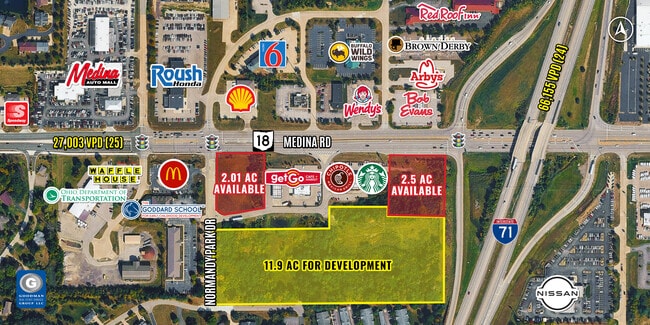


Property Detail
Medina Rd
Cleveland-Elyria, OH
TOWNSHIP02N RNG14N
030-11B-04-022
MEDINA
Stateproperty
Ohio
B and X Area of moderate flood hazard, usually the area between the limits of the 100-year and 500-year floods.
87
0
2.03 AC
2025
Medina County
408001
Cleveland
NEARBY LISTINGS FOR SALE OR LEASE
DEMOGRAPHICS near Medina Rd
1 mile
3 mile
5 mile
2025 Total Population
3,761
20,710
55,606
2030 Population
3,821
20,828
56,045
Pop Growth 2025-2030
+ 1.60%
+ 0.57%
+ 0.79%
Average Age
45
43
43
2025 Total Households
1,561
7,895
21,853
HH Growth 2025-2030
+ 1.67%
+ 0.66%
+ 0.86%
Median Household Inc
$122,655
$113,020
$96,394
Avg Household Size
2.40
2.60
2.50
2025 Avg HH Vehicles
2.00
2.00
2.00
Median Home Value
$428,856
$358,186
$321,996
Median Year Built
1994
1991
1991
Nearby Places
Map Layers
Map Styles
 Street
 Aerial
Layers
 Traffic
 Biking
Places
Listings with unknown addresses are not visible on the map
- Restaurants
- Banks
- Shops
- Fitness
- Groceries
PUBLIC TRANSPORTATION
AIRPORT
Cleveland-Hopkins International
Drive
Walk
Distance
Cleveland-Hopkins International
31 min
22.7 mi
Akron-Canton Regional
Drive
Walk
Distance
Akron-Canton Regional
41 min
30.4 mi
Freight Ports
Port of Toledo
Drive
Walk
Distance
Port of Toledo
144 min
118.7 mi
SALE & LEASE HISTORY
LISTING DATE
SALE/LEASE

Sep 24, 2016
For Sale
May 30, 2017
For Sale
Jul 28, 2017
For Sale
Feb 20, 2018
For Sale
Nearby Properties
Address
Land Use
TOTAL SIZE
Lot Size
Zoning
Address
Land Use
TOTAL SIZE
Lot Size
Zoning
32,644 SF
117.07 AC
Address
Land Use
TOTAL SIZE
Lot Size
Zoning
19,679 SF
13.39 AC
Address
Land Use
TOTAL SIZE
Lot Size
Zoning
23,040 SF
125 AC
Address
Land Use
TOTAL SIZE
Lot Size
Zoning
12,324 SF
9.37 AC
Address
Land Use
TOTAL SIZE
Lot Size
Zoning
77,760 SF
5.43 AC
Address
Land Use
TOTAL SIZE
Lot Size
Zoning
9,600 SF
72.61 AC
Address
Land Use
TOTAL SIZE
Lot Size
Zoning
15,876 SF
33.29 AC
Address
Land Use
TOTAL SIZE
Lot Size
Zoning
13,360 SF
24.13 AC
Address
Land Use
TOTAL SIZE
Lot Size
Zoning
71,072 SF
7.45 AC
Address
Land Use
TOTAL SIZE
Lot Size
Zoning
104,009 SF
20.16 AC
Address
Land Use
TOTAL SIZE
Lot Size
Zoning
8,346 SF
19.30 AC
Address
Land Use
TOTAL SIZE
Lot Size
Zoning
132,671 SF
32.37 AC
Address
Land Use
TOTAL SIZE
Lot Size
Zoning
94,168 SF
11.88 AC
Address
Land Use
TOTAL SIZE
Lot Size
Zoning
22,204 SF
7.92 AC
Address
Land Use
TOTAL SIZE
Lot Size
Zoning
24,320 SF
6.42 AC
Address
Land Use
TOTAL SIZE
Lot Size
Zoning
16,736 SF
3.34 AC
Address
Land Use
TOTAL SIZE
Lot Size
Zoning
1,088 SF
191.03 AC
Address
Land Use
TOTAL SIZE
Lot Size
Zoning
57,868 SF
2.49 AC
Address
Land Use
TOTAL SIZE
Lot Size
Zoning
34,054 SF
3.37 AC
Address
Land Use
TOTAL SIZE
Lot Size
Zoning
19,924 SF
4.58 AC
Address
Land Use
TOTAL SIZE
Lot Size
Zoning
2,368 SF
11.79 AC
Address
Land Use
TOTAL SIZE
Lot Size
Zoning
6,714 SF
165.86 AC
Address
Land Use
TOTAL SIZE
Lot Size
Zoning
38,209 SF
3.83 AC
Address
Land Use
TOTAL SIZE
Lot Size
Zoning
5,306 SF
12.78 AC
Address
Land Use
TOTAL SIZE
Lot Size
Zoning
36,246 SF
4.19 AC
Address
Land Use
TOTAL SIZE
Lot Size
Zoning
53,664 SF
8.73 AC
Address
Land Use
TOTAL SIZE
Lot Size
Zoning
11,776 SF
19.74 AC
Address
Land Use
TOTAL SIZE
Lot Size
Zoning
13,920 SF
7.10 AC
Address
Land Use
TOTAL SIZE
Lot Size
Zoning
30,624 SF
7.80 AC
Address
Land Use
TOTAL SIZE
Lot Size
Zoning
99,409 SF
25.31 AC
The World's #1 Commercial Real Estate Marketplace
Connect with us
© 2026 CoStar Group
The information above has been obtained from sources believed reliable. While we do not doubt its accuracy we have not verified it and make no guarantee, warranty or representation about it. It is your responsibility to independently confirm its accuracy and completeness. Any projections, opinions, assumptions, or estimates used are for example only and do not represent the current or future performance of the property. The value of this transaction to you depends on tax and other factors which should be evaluated by your tax, financial, and legal advisors. You and your advisors should conduct a careful, independent investigation of the property to determine to your satisfaction the suitability of the property for your needs.