Property Record
Route 169, Jersey City, NJ 07305


NEARBY LISTINGS FOR SALE OR LEASE
Property Detail
Route 169
New York-Jersey City-White Plains, NY-NJ
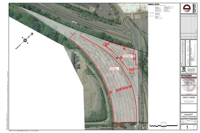
FACILITY NAME: VACANT LAND
06-30306-0000-00002
Hudson
Governmentalpublicusegeneral
New Jersey
X
2
34003C0268H
9.70 AC
0
Hudson Waterfront
2025
Northern New Jersey
005801
DEMOGRAPHICS near Route 169
1 Mile
3 Mile
5 Mile
2024 Total Population
29,211
177,176
663,882
2029 Population
27,781
169,058
639,827
Pop Growth 2024-2029
(4.90%)
(4.58%)
(3.62%)
Average Age
39
39
38
2024 Total Households
10,725
66,812
263,515
HH Growth 2024-2029
(5.49%)
(4.95%)
(3.88%)
Median Household Inc
$65,408
$64,256
$87,047
Avg Household Size
2.60
2.50
2.40
2024 Avg HH Vehicles
1.00
1.00
1.00
Median Home Value
$382,971
$390,837
$581,638
Median Year Built
1960
1958
1964
Nearby Places
Map Layers
Map Styles
 Street
 Aerial
- Restaurants
- Banks
- Shops
- Fitness
- Groceries
PUBLIC TRANSPORTATION
TRANSIT/SUBWAY
Danforth Avenue (22nd Street-Hoboken Terminal - Hudson-Bergen Light Rail (Hudson-Bergen Light Rail))
DRIVE
WALK
Distance
Danforth Avenue (22nd Street-Hoboken Terminal - Hudson-Bergen Light Rail (Hudson-Bergen Light Rail))
2 min
20 min
1.1 mi
AIRPORT
Newark Liberty International
DRIVE
WALK
Distance
Newark Liberty International
11 min
7.2 mi
LaGuardia
DRIVE
WALK
Distance
LaGuardia
37 min
18.0 mi
John F Kennedy International
DRIVE
WALK
Distance
John F Kennedy International
46 min
26.2 mi
Freight Ports
GCT Bayonne
DRIVE
WALK
Distance
GCT Bayonne
9 min
3.1 mi
SALE & LEASE HISTORY
LISTING DATE
SALE/LEASE

Jun 24, 2020
For Lease
Nearby Properties
Address
Land Use
TOTAL SIZE
Lot Size
Zoning
Address
Land Use
TOTAL SIZE
Lot Size
Zoning
229.72 AC
Address
Land Use
TOTAL SIZE
Lot Size
Zoning
98.48 AC
Address
Land Use
TOTAL SIZE
Lot Size
Zoning
131.26 AC
Address
Land Use
TOTAL SIZE
Lot Size
Zoning
Address
Land Use
TOTAL SIZE
Lot Size
Zoning
1.15 AC
Address
Land Use
TOTAL SIZE
Lot Size
Zoning
Address
Land Use
TOTAL SIZE
Lot Size
Zoning
216 AC
Address
Land Use
TOTAL SIZE
Lot Size
Zoning
22.49 AC
HC
Address
Land Use
TOTAL SIZE
Lot Size
Zoning
Address
Land Use
TOTAL SIZE
Lot Size
Zoning
Address
Land Use
TOTAL SIZE
Lot Size
Zoning
81.18 AC
Address
Land Use
TOTAL SIZE
Lot Size
Zoning
Address
Land Use
TOTAL SIZE
Lot Size
Zoning
75.51 AC
Address
Land Use
TOTAL SIZE
Lot Size
Zoning
603,130 SF
63.46 AC
R3-2
Address
Land Use
TOTAL SIZE
Lot Size
Zoning
69.45 AC
Address
Land Use
TOTAL SIZE
Lot Size
Zoning
108.75 AC
Address
Land Use
TOTAL SIZE
Lot Size
Zoning
64.40 AC
Address
Land Use
TOTAL SIZE
Lot Size
Zoning
63.35 AC
Address
Land Use
TOTAL SIZE
Lot Size
Zoning
2.54 AC
Address
Land Use
TOTAL SIZE
Lot Size
Zoning
53.66 AC
Address
Land Use
TOTAL SIZE
Lot Size
Zoning
12.50 AC
Address
Land Use
TOTAL SIZE
Lot Size
Zoning
30.92 AC
Address
Land Use
TOTAL SIZE
Lot Size
Zoning
3.27 AC
Address
Land Use
TOTAL SIZE
Lot Size
Zoning
27.49 AC
Address
Land Use
TOTAL SIZE
Lot Size
Zoning
17.60 AC
Address
Land Use
TOTAL SIZE
Lot Size
Zoning
Address
Land Use
TOTAL SIZE
Lot Size
Zoning
Address
Land Use
TOTAL SIZE
Lot Size
Zoning
28.47 AC
I-H
Address
Land Use
TOTAL SIZE
Lot Size
Zoning
114.66 AC
BMHO
Address
Land Use
TOTAL SIZE
Lot Size
Zoning
89.40 AC
R1
The World's #1 Commercial Real Estate Marketplace
Connect with us
© 2025 CoStar Group
The information above has been obtained from sources believed reliable. While we do not doubt its accuracy we have not verified it and make no guarantee, warranty or representation about it. It is your responsibility to independently confirm its accuracy and completeness. Any projections, opinions, assumptions, or estimates used are for example only and do not represent the current or future performance of the property. The value of this transaction to you depends on tax and other factors which should be evaluated by your tax, financial, and legal advisors. You and your advisors should conduct a careful, independent investigation of the property to determine to your satisfaction the suitability of the property for your needs.