Property Record
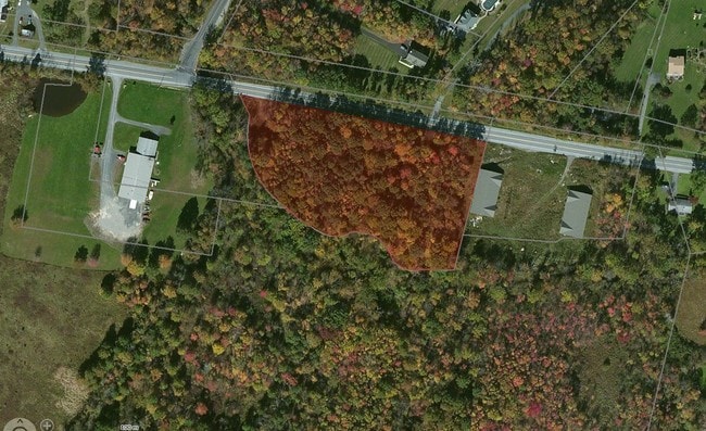
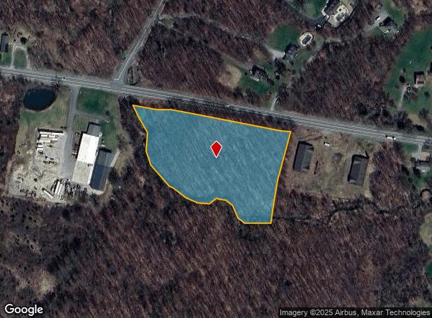
Rte 17K, Wallkill, NY 12589
NEARBY LISTINGS FOR SALE OR LEASE
Property Detail
Rte 17K
Kiryas Joel-Poughkeepsie-Newburgh, NY
Baer
335200-001-000-0001-045.610-0000
LT 1 BAER SUB MAP 815-04
Commercialacreage
Orange
X
New York
36105C0666F
45.61
2024
4.60 AC
2024
Middletown
955400
Northern New Jersey
DEMOGRAPHICS near Rte 17K
1 Mile
3 Mile
5 Mile
2024 Total Population
313
8,431
17,900
2029 Population
319
8,587
18,104
Pop Growth 2024-2029
+ 1.92%
+ 1.85%
+ 1.14%
Average Age
43
38
40
2024 Total Households
97
2,739
6,163
HH Growth 2024-2029
+ 2.06%
+ 1.75%
+ 1.10%
Median Household Inc
$118,951
$90,104
$96,261
Avg Household Size
2.70
2.90
2.80
2024 Avg HH Vehicles
2.00
2.00
2.00
Median Home Value
$342,000
$296,804
$297,839
Median Year Built
1992
1983
1981
Nearby Places
Map Layers
Map Styles
 Street
 Aerial
- Restaurants
- Banks
- Shops
- Fitness
- Groceries
PUBLIC TRANSPORTATION
COMMUTER RAIL
Middletown New York (Bergen County/Port Jervis Line - NJ Transit Commuter Rail (NJ Transit), Main/Port Jervis Line - NJ Transit Commuter Rail (NJ Transit))
DRIVE
WALK
Distance
Middletown New York (Bergen County/Port Jervis Line - NJ Transit Commuter Rail (NJ Transit), Main/Port Jervis Line - NJ Transit Commuter Rail (NJ Transit))
14 min
9.0 mi
AIRPORT
New York Stewart International
DRIVE
WALK
Distance
New York Stewart International
29 min
19.1 mi
Freight Ports
Port Newark Container Terminal
DRIVE
WALK
Distance
Port Newark Container Terminal
99 min
77.9 mi
SALE & LEASE HISTORY
LISTING DATE
SALE/LEASE

Sep 24, 2016
For Sale
Nov 06, 2019
For Sale
Apr 17, 2017
For Sale
Nearby Properties
Address
Land Use
TOTAL SIZE
Lot Size
Zoning
Address
Land Use
TOTAL SIZE
Lot Size
Zoning
35.70 AC
R2
Address
Land Use
TOTAL SIZE
Lot Size
Zoning
4,219 SF
86.85 AC
RAG1
Address
Land Use
TOTAL SIZE
Lot Size
Zoning
3,606 SF
60.55 AC
BR
Address
Land Use
TOTAL SIZE
Lot Size
Zoning
20.90 AC
Address
Land Use
TOTAL SIZE
Lot Size
Zoning
924 SF
20.01 AC
HC
Address
Land Use
TOTAL SIZE
Lot Size
Zoning
1,856 SF
142.10 AC
RA07
Address
Land Use
TOTAL SIZE
Lot Size
Zoning
2.35 AC
Address
Land Use
TOTAL SIZE
Lot Size
Zoning
17,135 SF
3.26 AC
Address
Land Use
TOTAL SIZE
Lot Size
Zoning
30,657 SF
135.40 AC
RA07
Address
Land Use
TOTAL SIZE
Lot Size
Zoning
57,942 SF
14.60 AC
R2
Address
Land Use
TOTAL SIZE
Lot Size
Zoning
38.50 AC
07
Address
Land Use
TOTAL SIZE
Lot Size
Zoning
Address
Land Use
TOTAL SIZE
Lot Size
Zoning
9,000 SF
17.67 AC
LNR
Address
Land Use
TOTAL SIZE
Lot Size
Zoning
104.23 AC
Address
Land Use
TOTAL SIZE
Lot Size
Zoning
247.69 AC
RAG1
Address
Land Use
TOTAL SIZE
Lot Size
Zoning
4,284 SF
13.80 AC
AR
Address
Land Use
TOTAL SIZE
Lot Size
Zoning
1.41 AC
Address
Land Use
TOTAL SIZE
Lot Size
Zoning
4,978 SF
9.90 AC
ENT-L
Address
Land Use
TOTAL SIZE
Lot Size
Zoning
73.60 AC
07
Address
Land Use
TOTAL SIZE
Lot Size
Zoning
3,440 SF
1.16 AC
Address
Land Use
TOTAL SIZE
Lot Size
Zoning
1,624 SF
17.75 AC
Address
Land Use
TOTAL SIZE
Lot Size
Zoning
1,500 SF
56.20 AC
R1
Address
Land Use
TOTAL SIZE
Lot Size
Zoning
2,400 SF
25.30 AC
ENT-L
Address
Land Use
TOTAL SIZE
Lot Size
Zoning
29,588 SF
17.90 AC
ENT-L
Address
Land Use
TOTAL SIZE
Lot Size
Zoning
10.90 AC
Address
Land Use
TOTAL SIZE
Lot Size
Zoning
10,086 SF
0.29 AC
Address
Land Use
TOTAL SIZE
Lot Size
Zoning
80.80 AC
Address
Land Use
TOTAL SIZE
Lot Size
Zoning
17.80 AC
Address
Land Use
TOTAL SIZE
Lot Size
Zoning
Address
Land Use
TOTAL SIZE
Lot Size
Zoning
8,382 SF
1.10 AC
The World's #1 Commercial Real Estate Marketplace
Connect with us
© 2026 CoStar Group
The information above has been obtained from sources believed reliable. While we do not doubt its accuracy we have not verified it and make no guarantee, warranty or representation about it. It is your responsibility to independently confirm its accuracy and completeness. Any projections, opinions, assumptions, or estimates used are for example only and do not represent the current or future performance of the property. The value of this transaction to you depends on tax and other factors which should be evaluated by your tax, financial, and legal advisors. You and your advisors should conduct a careful, independent investigation of the property to determine to your satisfaction the suitability of the property for your needs.