Property Record
State Rte 72, Kirkland, IL 60146

Property Detail
State Rte 72
Chicago-Naperville-Elgin, IL-IN
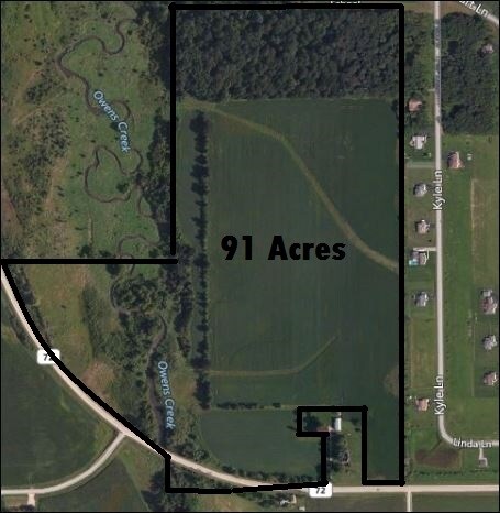
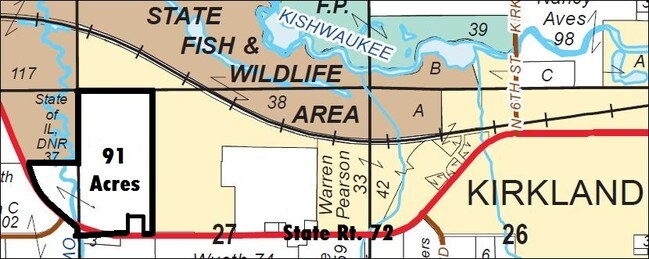
PT W1/2 NW1/4 - SEC 27 & PT NE1/4 - SEC 28 - T42N R3E
01-27-100-007
DEKALB
Farms
Illinois
AE The base floodplain where base flood elevations are provided. AE Zones are now used on new format FIRMs instead of A1-A30 Zones.
90.94 AC
2023
Far Northwest
2024
Chicago
000200
NEARBY LISTINGS FOR SALE OR LEASE
-
-
View all Kirkland listings for sale on LoopNet.com
DEMOGRAPHICS near State Rte 72
1 mile
3 mile
5 mile
2025 Total Population
225
1,780
2,447
2030 Population
216
1,716
2,367
Pop Growth 2025-2030
(4.00%)
(3.60%)
(3.27%)
Average Age
38
40
41
2025 Total Households
85
681
951
HH Growth 2025-2030
(4.71%)
(3.38%)
(3.15%)
Median Household Inc
$83,928
$87,500
$90,908
Avg Household Size
2.70
2.60
2.60
2025 Avg HH Vehicles
2.00
2.00
2.00
Median Home Value
$187,096
$213,366
$230,228
Median Year Built
1968
1970
1968
Nearby Places
Map Layers
Map Styles
 Street
 Aerial
Transit
 Traffic
 Biking
Places
Listings with unknown addresses are not visible on the map
- Restaurants
- Banks
- Shops
- Fitness
- Groceries
PUBLIC TRANSPORTATION
AIRPORT
Chicago/Rockford International
Drive
Walk
Distance
Chicago/Rockford International
31 min
18.7 mi
Freight Ports
Port Milwaukee
Drive
Walk
Distance
Port Milwaukee
131 min
110.7 mi
SALE & LEASE HISTORY
LISTING DATE
SALE/LEASE

Apr 07, 2017
For Sale
Nearby Properties
Address
Land Use
TOTAL SIZE
Lot Size
Zoning
Address
Land Use
TOTAL SIZE
Lot Size
Zoning
4.71 AC
A1
Address
Land Use
TOTAL SIZE
Lot Size
Zoning
10 AC
MC
Address
Land Use
TOTAL SIZE
Lot Size
Zoning
1.28 AC
Address
Land Use
TOTAL SIZE
Lot Size
Zoning
3.92 AC
Address
Land Use
TOTAL SIZE
Lot Size
Zoning
Address
Land Use
TOTAL SIZE
Lot Size
Zoning
0.28 AC
Address
Land Use
TOTAL SIZE
Lot Size
Zoning
1.03 AC
Address
Land Use
TOTAL SIZE
Lot Size
Zoning
3.37 AC
Address
Land Use
TOTAL SIZE
Lot Size
Zoning
6.52 AC
Address
Land Use
TOTAL SIZE
Lot Size
Zoning
35 AC
A1
Address
Land Use
TOTAL SIZE
Lot Size
Zoning
2.52 AC
Address
Land Use
TOTAL SIZE
Lot Size
Zoning
0.51 AC
Address
Land Use
TOTAL SIZE
Lot Size
Zoning
2.40 AC
Address
Land Use
TOTAL SIZE
Lot Size
Zoning
13.33 AC
A1
Address
Land Use
TOTAL SIZE
Lot Size
Zoning
17 AC
A1
Address
Land Use
TOTAL SIZE
Lot Size
Zoning
164.50 AC
A1
Address
Land Use
TOTAL SIZE
Lot Size
Zoning
0.09 AC
Address
Land Use
TOTAL SIZE
Lot Size
Zoning
117.27 AC
A1
Address
Land Use
TOTAL SIZE
Lot Size
Zoning
130.86 AC
A1
Address
Land Use
TOTAL SIZE
Lot Size
Zoning
146.56 AC
A1
Address
Land Use
TOTAL SIZE
Lot Size
Zoning
160 AC
A1
Address
Land Use
TOTAL SIZE
Lot Size
Zoning
131.97 AC
A1
Address
Land Use
TOTAL SIZE
Lot Size
Zoning
3.75 AC
Address
Land Use
TOTAL SIZE
Lot Size
Zoning
0.29 AC
Address
Land Use
TOTAL SIZE
Lot Size
Zoning
148.76 AC
A1
Address
Land Use
TOTAL SIZE
Lot Size
Zoning
0.30 AC
Address
Land Use
TOTAL SIZE
Lot Size
Zoning
160.74 AC
A1
Address
Land Use
TOTAL SIZE
Lot Size
Zoning
160 AC
A1
Address
Land Use
TOTAL SIZE
Lot Size
Zoning
118.06 AC
A1
Address
Land Use
TOTAL SIZE
Lot Size
Zoning
0.31 AC
The World's #1 Commercial Real Estate Marketplace
Connect with us
© 2026 CoStar Group
The information above has been obtained from sources believed reliable. While we do not doubt its accuracy we have not verified it and make no guarantee, warranty or representation about it. It is your responsibility to independently confirm its accuracy and completeness. Any projections, opinions, assumptions, or estimates used are for example only and do not represent the current or future performance of the property. The value of this transaction to you depends on tax and other factors which should be evaluated by your tax, financial, and legal advisors. You and your advisors should conduct a careful, independent investigation of the property to determine to your satisfaction the suitability of the property for your needs.