Property Record
Rubicon Pl, Melville, NY 11747
NEARBY LISTINGS FOR SALE OR LEASE
-
-
View all Melville listings for sale on LoopNet.com
Property Detail
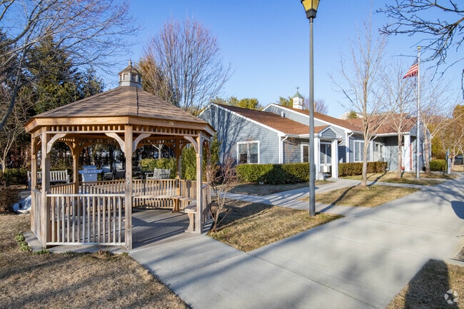
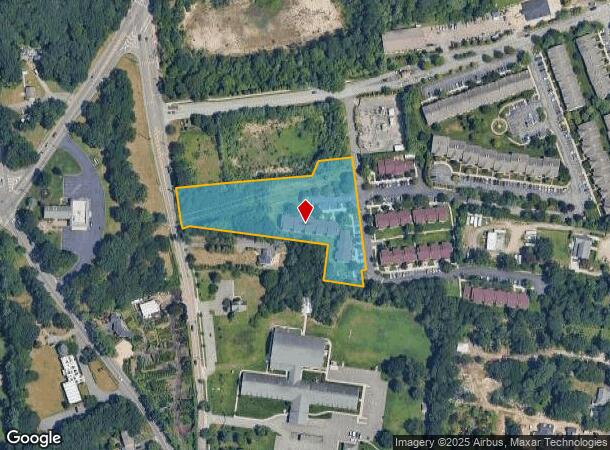
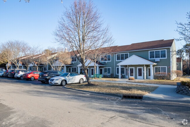
Rubicon Pl
Nassau County-Suffolk County, NY
The Greens At Half Hollow
0400-257-00-02-00-060-001
MAP OF THE GREENS @ HALF W - SEC 1 - PHASE 1
Residentialacreage
Suffolk
X
New York
36103C0620H
60
0
2.50 AC
2024
Melville
112219
Long Island (New York)
DEMOGRAPHICS near Rubicon Pl
1 Mile
3 Mile
5 Mile
2024 Total Population
9,266
53,536
198,878
2029 Population
9,148
52,594
195,249
Pop Growth 2024-2029
(1.27%)
(1.76%)
(1.82%)
Average Age
49
44
42
2024 Total Households
3,640
18,284
63,719
HH Growth 2024-2029
(1.26%)
(1.94%)
(1.98%)
Median Household Inc
$113,513
$141,718
$135,495
Avg Household Size
2.50
2.80
3.00
2024 Avg HH Vehicles
2.00
2.00
2.00
Median Home Value
$755,020
$700,860
$653,606
Median Year Built
1987
1966
1964
Nearby Places
- Restaurants
- Banks
- Shops
- Fitness
- Groceries
PUBLIC TRANSPORTATION
COMMUTER RAIL
Pinelawn Station (Ronkonkoma Branch - Long Island Rail Road)
DRIVE
WALK
Distance
Pinelawn Station (Ronkonkoma Branch - Long Island Rail Road)
10 min
4.5 mi
Wyandanch Station (Ronkonkoma Branch - Long Island Rail Road)
DRIVE
WALK
Distance
Wyandanch Station (Ronkonkoma Branch - Long Island Rail Road)
13 min
5.9 mi
AIRPORT
Long Island MacArthur
DRIVE
WALK
Distance
Long Island MacArthur
31 min
17.8 mi
John F Kennedy International
DRIVE
WALK
Distance
John F Kennedy International
44 min
30.3 mi
Westchester County
DRIVE
WALK
Distance
Westchester County
75 min
49.6 mi
Freight Ports
NY - Red Hook Container Terminal
DRIVE
WALK
Distance
NY - Red Hook Container Terminal
56 min
37.3 mi
Nearby Properties
Address
Land Use
TOTAL SIZE
Lot Size
Zoning
Address
Land Use
TOTAL SIZE
Lot Size
Zoning
37 AC
I2
Address
Land Use
TOTAL SIZE
Lot Size
Zoning
3.31 AC
R40
Address
Land Use
TOTAL SIZE
Lot Size
Zoning
16,520 SF
160.33 AC
Address
Land Use
TOTAL SIZE
Lot Size
Zoning
33.80 AC
Address
Land Use
TOTAL SIZE
Lot Size
Zoning
52.10 AC
Address
Land Use
TOTAL SIZE
Lot Size
Zoning
37.20 AC
I2
Address
Land Use
TOTAL SIZE
Lot Size
Zoning
32.67 AC
R80
Address
Land Use
TOTAL SIZE
Lot Size
Zoning
82 AC
R40
Address
Land Use
TOTAL SIZE
Lot Size
Zoning
24.75 AC
R40
Address
Land Use
TOTAL SIZE
Lot Size
Zoning
11.50 AC
C10
Address
Land Use
TOTAL SIZE
Lot Size
Zoning
2.92 AC
R20
Address
Land Use
TOTAL SIZE
Lot Size
Zoning
12 AC
I1
Address
Land Use
TOTAL SIZE
Lot Size
Zoning
22.20 AC
I1
Address
Land Use
TOTAL SIZE
Lot Size
Zoning
14.40 AC
I1
Address
Land Use
TOTAL SIZE
Lot Size
Zoning
0.26 AC
R20
Address
Land Use
TOTAL SIZE
Lot Size
Zoning
32.60 AC
I1
Address
Land Use
TOTAL SIZE
Lot Size
Zoning
52.20 AC
R40
Address
Land Use
TOTAL SIZE
Lot Size
Zoning
16 AC
I1
Address
Land Use
TOTAL SIZE
Lot Size
Zoning
23.66 AC
I1
Address
Land Use
TOTAL SIZE
Lot Size
Zoning
21.50 AC
I1
Address
Land Use
TOTAL SIZE
Lot Size
Zoning
265.70 AC
R80
Address
Land Use
TOTAL SIZE
Lot Size
Zoning
21.10 AC
C5
Address
Land Use
TOTAL SIZE
Lot Size
Zoning
13.12 AC
R40
Address
Land Use
TOTAL SIZE
Lot Size
Zoning
33 AC
R40
Address
Land Use
TOTAL SIZE
Lot Size
Zoning
260,092 SF
7.07 AC
GA
Address
Land Use
TOTAL SIZE
Lot Size
Zoning
7.50 AC
C2
Address
Land Use
TOTAL SIZE
Lot Size
Zoning
30.30 AC
R40
Address
Land Use
TOTAL SIZE
Lot Size
Zoning
14.50 AC
C10
Address
Land Use
TOTAL SIZE
Lot Size
Zoning
232.90 AC
A
Address
Land Use
TOTAL SIZE
Lot Size
Zoning
11 AC
R40
The World's #1 Commercial Real Estate Marketplace
Connect with us
© 2025 CoStar Group
The information above has been obtained from sources believed reliable. While we do not doubt its accuracy we have not verified it and make no guarantee, warranty or representation about it. It is your responsibility to independently confirm its accuracy and completeness. Any projections, opinions, assumptions, or estimates used are for example only and do not represent the current or future performance of the property. The value of this transaction to you depends on tax and other factors which should be evaluated by your tax, financial, and legal advisors. You and your advisors should conduct a careful, independent investigation of the property to determine to your satisfaction the suitability of the property for your needs.