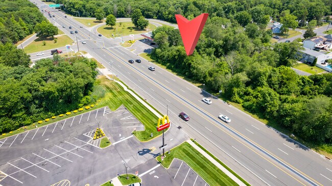
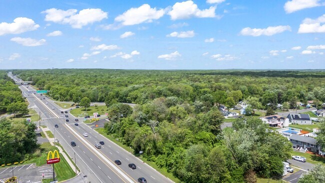
Property Record
Rustic Dr, Howell, NJ 07731

Save to a Folder
{{folder.Name}}
{{folder.ListingIds.length}} Properties
{{folder.ListingIds.length}} Property
Create a New Folder
Property Detail
Rustic Dr
21-00056-0000-00011
MONMOUTH
Vacantlandnec
New Jersey
C125
11
B and X Area of moderate flood hazard, usually the area between the limits of the 100-year and 500-year floods.
0.41 AC
2025
Western Monmouth
2026
Northern New Jersey
811402
Lakewood-New Brunswick, NJ
NEARBY LISTINGS FOR SALE OR LEASE
DEMOGRAPHICS near Rustic Dr
1 mile
3 mile
5 mile
2025 Total Population
6,713
39,764
132,275
2030 Population
6,685
39,804
131,558
Pop Growth 2025-2030
(0.42%)
+ 0.10%
(0.54%)
Average Age
41
39
34
2025 Total Households
2,181
12,707
38,243
HH Growth 2025-2030
(0.69%)
(0.39%)
(1.10%)
Median Household Inc
$116,503
$117,642
$99,558
Avg Household Size
3.00
3.00
3.20
2025 Avg HH Vehicles
2.00
2.00
2.00
Median Home Value
$492,127
$495,814
$493,067
Median Year Built
1976
1980
1985
Nearby Places
Map Layers
Map Styles
 Street
 Aerial
Layers
 Traffic
 Biking
Places
Listings with unknown addresses are not visible on the map
- Restaurants
- Banks
- Shops
- Fitness
- Groceries
SALE & LEASE HISTORY
LISTING DATE
SALE/LEASE

Jun 28, 2024
For Sale
Jul 17, 2025
For Sale
Nearby Properties
Address
Land Use
TOTAL SIZE
Lot Size
Zoning
Address
Land Use
TOTAL SIZE
Lot Size
Zoning
24.15 AC
MF
Address
Land Use
TOTAL SIZE
Lot Size
Zoning
36,678 SF
38.75 AC
MFAH
Address
Land Use
TOTAL SIZE
Lot Size
Zoning
161,340 SF
35.35 AC
HD-1
Address
Land Use
TOTAL SIZE
Lot Size
Zoning
25.63 AC
HD-1
Address
Land Use
TOTAL SIZE
Lot Size
Zoning
14.90 AC
PFE
Address
Land Use
TOTAL SIZE
Lot Size
Zoning
237,479 SF
21 AC
LC
Address
Land Use
TOTAL SIZE
Lot Size
Zoning
136,800 SF
14.08 AC
ARE1
Address
Land Use
TOTAL SIZE
Lot Size
Zoning
28.99 AC
HD-1
Address
Land Use
TOTAL SIZE
Lot Size
Zoning
14.73 AC
R-5
Address
Land Use
TOTAL SIZE
Lot Size
Zoning
43.22 AC
ARE2
Address
Land Use
TOTAL SIZE
Lot Size
Zoning
360,400 SF
35.98 AC
SED
Address
Land Use
TOTAL SIZE
Lot Size
Zoning
112 SF
20.47 AC
HCMF
Address
Land Use
TOTAL SIZE
Lot Size
Zoning
70.60 AC
RE
Address
Land Use
TOTAL SIZE
Lot Size
Zoning
98,731 SF
13.65 AC
HD
Address
Land Use
TOTAL SIZE
Lot Size
Zoning
6,210 SF
5 AC
HC
Address
Land Use
TOTAL SIZE
Lot Size
Zoning
117,975 SF
21.20 AC
C50
Address
Land Use
TOTAL SIZE
Lot Size
Zoning
125,379 SF
22.16 AC
HD
Address
Land Use
TOTAL SIZE
Lot Size
Zoning
141,437 SF
13.35 AC
HD-1
Address
Land Use
TOTAL SIZE
Lot Size
Zoning
51,531 SF
13.30 AC
HD
Address
Land Use
TOTAL SIZE
Lot Size
Zoning
58.80 AC
R-E
Address
Land Use
TOTAL SIZE
Lot Size
Zoning
24,630 SF
6.93 AC
HD-1
Address
Land Use
TOTAL SIZE
Lot Size
Zoning
94,480 SF
11.11 AC
C50
Address
Land Use
TOTAL SIZE
Lot Size
Zoning
5.08 AC
NC
Address
Land Use
TOTAL SIZE
Lot Size
Zoning
123,578 SF
9.28 AC
HD-1
Address
Land Use
TOTAL SIZE
Lot Size
Zoning
66,768 SF
10.90 AC
ARE2
Address
Land Use
TOTAL SIZE
Lot Size
Zoning
46.70 AC
R-E
Address
Land Use
TOTAL SIZE
Lot Size
Zoning
71,996 SF
8.59 AC
HC
Address
Land Use
TOTAL SIZE
Lot Size
Zoning
8.96 AC
HD
Address
Land Use
TOTAL SIZE
Lot Size
Zoning
2,104 SF
22.90 AC
SF40
Address
Land Use
TOTAL SIZE
Lot Size
Zoning
52,985 SF
20.92 AC
C50
The World's #1 Commercial Real Estate Marketplace
Connect with us
© 2026 CoStar Group
The information above has been obtained from sources believed reliable. While we do not doubt its accuracy we have not verified it and make no guarantee, warranty or representation about it. It is your responsibility to independently confirm its accuracy and completeness. Any projections, opinions, assumptions, or estimates used are for example only and do not represent the current or future performance of the property. The value of this transaction to you depends on tax and other factors which should be evaluated by your tax, financial, and legal advisors. You and your advisors should conduct a careful, independent investigation of the property to determine to your satisfaction the suitability of the property for your needs.