Property Record
S 60Th St, Papillion, NE 68046

Save to a Folder
{{folder.Name}}
{{folder.ListingIds.length}} Properties
{{folder.ListingIds.length}} Property
Create a New Folder
Property Detail
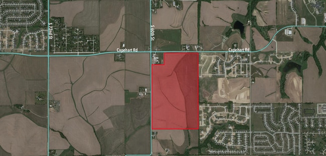
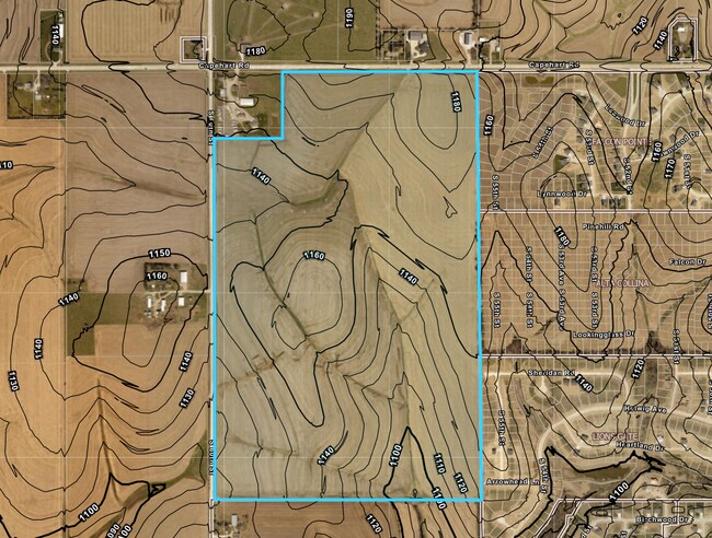
S 60Th St
Omaha, NE-IA
N1/2 SW1/4 & NW1/4 EX N 660 OF W 660 7-13-13 (210.34 AC)
010485368
SARPY
Agriculturalland
Nebraska
AG
2
B and X Area of moderate flood hazard, usually the area between the limits of the 100-year and 500-year floods.
209.62 AC
2024
Southeast Omaha
2025
Omaha/Council Bluffs
010203
NEARBY LISTINGS FOR SALE OR LEASE
DEMOGRAPHICS near S 60Th St
1 mile
3 mile
5 mile
2025 Total Population
2,929
43,581
102,208
2030 Population
3,224
46,482
109,111
Pop Growth 2025-2030
+ 10.07%
+ 6.66%
+ 6.75%
Average Age
38
37
38
2025 Total Households
966
15,935
37,477
HH Growth 2025-2030
+ 10.56%
+ 6.93%
+ 6.99%
Median Household Inc
$117,391
$102,531
$104,508
Avg Household Size
3.00
2.70
2.70
2025 Avg HH Vehicles
2.00
2.00
2.00
Median Home Value
$369,172
$340,092
$324,401
Median Year Built
2008
1998
1996
Nearby Places
Map Layers
Map Styles
 Street
 Aerial
Layers
 Traffic
 Biking
Places
Listings with unknown addresses are not visible on the map
- Restaurants
- Banks
- Shops
- Fitness
- Groceries
PUBLIC TRANSPORTATION
AIRPORT
Eppley Airfield
Drive
Walk
Distance
Eppley Airfield
31 min
19.0 mi
Freight Ports
Tulsa Port Of Catoosa
Drive
Walk
Distance
Tulsa Port Of Catoosa
457 min
411.6 mi
SALE & LEASE HISTORY
LISTING DATE
SALE/LEASE

Nov 19, 2021
For Sale
Nearby Properties
Address
Land Use
TOTAL SIZE
Lot Size
Zoning
Address
Land Use
TOTAL SIZE
Lot Size
Zoning
483,925 SF
42.06 AC
Address
Land Use
TOTAL SIZE
Lot Size
Zoning
28,401 SF
27.31 AC
Address
Land Use
TOTAL SIZE
Lot Size
Zoning
3,906 SF
13.62 AC
RG20
Address
Land Use
TOTAL SIZE
Lot Size
Zoning
18,727 SF
11.15 AC
RG20
Address
Land Use
TOTAL SIZE
Lot Size
Zoning
143 SF
17.56 AC
RG28
Address
Land Use
TOTAL SIZE
Lot Size
Zoning
10,800 SF
12.03 AC
Address
Land Use
TOTAL SIZE
Lot Size
Zoning
88,545 SF
9.58 AC
Address
Land Use
TOTAL SIZE
Lot Size
Zoning
37,196 SF
13.96 AC
MU
Address
Land Use
TOTAL SIZE
Lot Size
Zoning
18,484 SF
5.47 AC
Address
Land Use
TOTAL SIZE
Lot Size
Zoning
117,829 SF
11.13 AC
BG
Address
Land Use
TOTAL SIZE
Lot Size
Zoning
11,244 SF
6.91 AC
Address
Land Use
TOTAL SIZE
Lot Size
Zoning
196,746 SF
10.22 AC
Address
Land Use
TOTAL SIZE
Lot Size
Zoning
92,567 SF
2.43 AC
Address
Land Use
TOTAL SIZE
Lot Size
Zoning
34,104 SF
6.55 AC
Address
Land Use
TOTAL SIZE
Lot Size
Zoning
87,718 SF
7.92 AC
Address
Land Use
TOTAL SIZE
Lot Size
Zoning
88,232 SF
6.72 AC
BG
Address
Land Use
TOTAL SIZE
Lot Size
Zoning
12,476 SF
8.39 AC
Address
Land Use
TOTAL SIZE
Lot Size
Zoning
1,160 SF
5.16 AC
Address
Land Use
TOTAL SIZE
Lot Size
Zoning
6,140 SF
7.05 AC
Address
Land Use
TOTAL SIZE
Lot Size
Zoning
29,867 SF
3.69 AC
Address
Land Use
TOTAL SIZE
Lot Size
Zoning
9,556 SF
7.40 AC
Address
Land Use
TOTAL SIZE
Lot Size
Zoning
331 SF
7.35 AC
Address
Land Use
TOTAL SIZE
Lot Size
Zoning
136,462 SF
9.66 AC
RG20
Address
Land Use
TOTAL SIZE
Lot Size
Zoning
94,033 SF
6.64 AC
Address
Land Use
TOTAL SIZE
Lot Size
Zoning
100,930 SF
6.80 AC
RG8
Address
Land Use
TOTAL SIZE
Lot Size
Zoning
75,928 SF
12.06 AC
BG
Address
Land Use
TOTAL SIZE
Lot Size
Zoning
56,660 SF
4.78 AC
Address
Land Use
TOTAL SIZE
Lot Size
Zoning
8,895 SF
5.75 AC
Address
Land Use
TOTAL SIZE
Lot Size
Zoning
103,615 SF
8.26 AC
Address
Land Use
TOTAL SIZE
Lot Size
Zoning
6,243 SF
2.85 AC
RG20
The World's #1 Commercial Real Estate Marketplace
Connect with us
© 2026 CoStar Group
The information above has been obtained from sources believed reliable. While we do not doubt its accuracy we have not verified it and make no guarantee, warranty or representation about it. It is your responsibility to independently confirm its accuracy and completeness. Any projections, opinions, assumptions, or estimates used are for example only and do not represent the current or future performance of the property. The value of this transaction to you depends on tax and other factors which should be evaluated by your tax, financial, and legal advisors. You and your advisors should conduct a careful, independent investigation of the property to determine to your satisfaction the suitability of the property for your needs.