Property Record
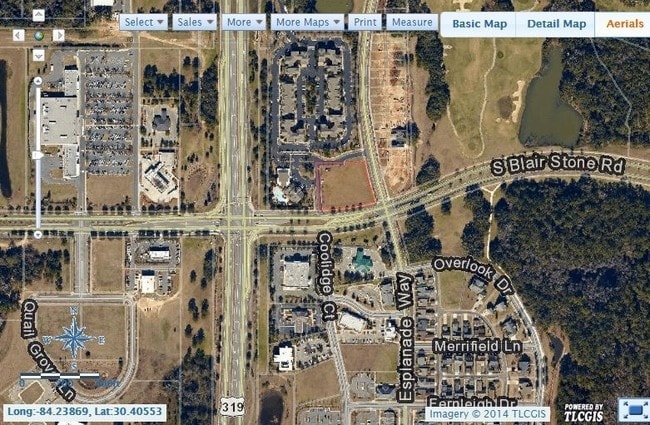
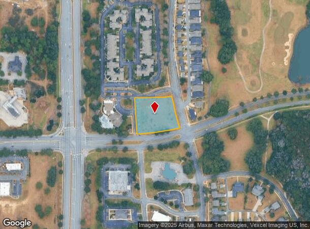
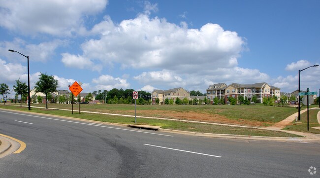
S Blair Stone Rd, Tallahassee, FL 32311

NEARBY LISTINGS FOR SALE OR LEASE
Property Detail
S Blair Stone Rd
Tallahassee, FL
Southwood Unit 24
31-16-24-000-002.0
SOUTHWOOD UNIT 24 16 1S 1E 1.395 A LOT 2
Commercialacreage
Leon
X
Florida
12073C0315F
2
2024
1.40 AC
2024
Southeast Leon County
002605
Tallahassee
DEMOGRAPHICS near S Blair Stone Rd
1 Mile
3 Mile
5 Mile
2024 Total Population
6,522
38,868
99,851
2029 Population
7,031
41,432
105,644
Pop Growth 2024-2029
+ 7.80%
+ 6.60%
+ 5.80%
Average Age
36
36
36
2024 Total Households
2,833
18,145
44,280
HH Growth 2024-2029
+ 7.94%
+ 6.66%
+ 6.05%
Median Household Inc
$80,211
$58,062
$52,853
Avg Household Size
2.30
2.10
2.10
2024 Avg HH Vehicles
2.00
2.00
2.00
Median Home Value
$352,924
$185,536
$215,964
Median Year Built
2008
1989
1987
Nearby Places
- Restaurants
- Banks
- Shops
- Fitness
- Groceries
PUBLIC TRANSPORTATION
AIRPORT
Tallahassee International
DRIVE
WALK
Distance
Tallahassee International
17 min
8.6 mi
SALE & LEASE HISTORY
LISTING DATE
SALE/LEASE

Sep 24, 2016
For Sale
Nearby Properties
Address
Land Use
TOTAL SIZE
Lot Size
Zoning
Address
Land Use
TOTAL SIZE
Lot Size
Zoning
2,331,883 SF
194.32 AC
PUD
Address
Land Use
TOTAL SIZE
Lot Size
Zoning
718,575 SF
47.84 AC
PUD
Address
Land Use
TOTAL SIZE
Lot Size
Zoning
84,693 SF
34.48 AC
Address
Land Use
TOTAL SIZE
Lot Size
Zoning
600,715 SF
30.63 AC
Address
Land Use
TOTAL SIZE
Lot Size
Zoning
846,072 SF
166.39 AC
R1
Address
Land Use
TOTAL SIZE
Lot Size
Zoning
200,705 SF
31.57 AC
Address
Land Use
TOTAL SIZE
Lot Size
Zoning
668,607 SF
20.12 AC
R4
Address
Land Use
TOTAL SIZE
Lot Size
Zoning
756,595 SF
18.35 AC
Address
Land Use
TOTAL SIZE
Lot Size
Zoning
608,342 SF
26.23 AC
CPA
Address
Land Use
TOTAL SIZE
Lot Size
Zoning
380,000 SF
21.78 AC
PUD
Address
Land Use
TOTAL SIZE
Lot Size
Zoning
740,790 SF
50.44 AC
PUD
Address
Land Use
TOTAL SIZE
Lot Size
Zoning
473,339 SF
51.93 AC
PUD
Address
Land Use
TOTAL SIZE
Lot Size
Zoning
621,490 SF
19.43 AC
PUD
Address
Land Use
TOTAL SIZE
Lot Size
Zoning
376,746 SF
12.92 AC
OR2
Address
Land Use
TOTAL SIZE
Lot Size
Zoning
636,937 SF
20.54 AC
Address
Land Use
TOTAL SIZE
Lot Size
Zoning
410,469 SF
50.04 AC
PUD
Address
Land Use
TOTAL SIZE
Lot Size
Zoning
737,861 SF
24.79 AC
OR2
Address
Land Use
TOTAL SIZE
Lot Size
Zoning
97,373 SF
16.38 AC
PUD
Address
Land Use
TOTAL SIZE
Lot Size
Zoning
619,964 SF
6.47 AC
OR3
Address
Land Use
TOTAL SIZE
Lot Size
Zoning
399,815 SF
18.65 AC
Address
Land Use
TOTAL SIZE
Lot Size
Zoning
338,619 SF
107.89 AC
GO1
Address
Land Use
TOTAL SIZE
Lot Size
Zoning
456,212 SF
117.40 AC
MR1
Address
Land Use
TOTAL SIZE
Lot Size
Zoning
424,598 SF
14.52 AC
MR1
Address
Land Use
TOTAL SIZE
Lot Size
Zoning
648,405 SF
20.01 AC
PUD
Address
Land Use
TOTAL SIZE
Lot Size
Zoning
196,912 SF
17.25 AC
CP
Address
Land Use
TOTAL SIZE
Lot Size
Zoning
269,446 SF
13.18 AC
AC
Address
Land Use
TOTAL SIZE
Lot Size
Zoning
272,762 SF
19.26 AC
RP2
Address
Land Use
TOTAL SIZE
Lot Size
Zoning
605,124 SF
15.72 AC
AC
Address
Land Use
TOTAL SIZE
Lot Size
Zoning
329,158 SF
14.67 AC
PUD
Address
Land Use
TOTAL SIZE
Lot Size
Zoning
292,562 SF
26.64 AC
The World's #1 Commercial Real Estate Marketplace
Connect with us
© 2025 CoStar Group
The information above has been obtained from sources believed reliable. While we do not doubt its accuracy we have not verified it and make no guarantee, warranty or representation about it. It is your responsibility to independently confirm its accuracy and completeness. Any projections, opinions, assumptions, or estimates used are for example only and do not represent the current or future performance of the property. The value of this transaction to you depends on tax and other factors which should be evaluated by your tax, financial, and legal advisors. You and your advisors should conduct a careful, independent investigation of the property to determine to your satisfaction the suitability of the property for your needs.