Property Record
S Cole Rd, Boise, ID 83709

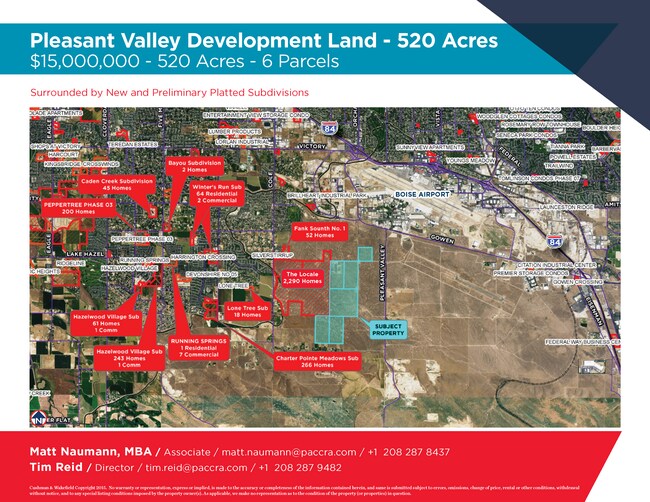
NEARBY LISTINGS FOR SALE OR LEASE
Property Detail
S Cole Rd
S1507110000
PRIOR REF: 2014-081672 10/06/2014
Vacantlandnec
Ada
X
Idaho
16001C0270H
80 AC
2024
Airport
2025
Boise City/Nampa
002229
Boise City, ID
DEMOGRAPHICS near S Cole Rd
1 mile
3 mile
5 mile
2024 Total Population
1,552
50,504
161,992
2029 Population
1,792
57,212
183,975
Pop Growth 2024-2029
+ 15.46%
+ 13.28%
+ 13.57%
Average Age
45
39
39
2024 Total Households
629
19,525
66,126
HH Growth 2024-2029
+ 15.58%
+ 13.60%
+ 13.99%
Median Household Inc
$81,084
$69,719
$67,459
Avg Household Size
2.50
2.50
2.30
2024 Avg HH Vehicles
2.00
2.00
2.00
Median Home Value
$433,333
$410,115
$436,400
Median Year Built
1977
1986
1988
Nearby Places
Map Layers
Map Styles
 Street
 Aerial
Transit
 Traffic
 Biking
Places
Listings with unknown addresses are not visible on the map
- Restaurants
- Banks
- Shops
- Fitness
- Groceries
PUBLIC TRANSPORTATION
AIRPORT
Boise Air Trml/Gowen Field
Drive
Walk
Distance
Boise Air Trml/Gowen Field
21 min
7.1 mi
Freight Ports
Port of Portland
Drive
Walk
Distance
Port of Portland
484 min
436.0 mi
SALE & LEASE HISTORY
LISTING DATE
SALE/LEASE

Jun 25, 2019
For Sale
Nearby Properties
Address
Land Use
TOTAL SIZE
Lot Size
Zoning
Address
Land Use
TOTAL SIZE
Lot Size
Zoning
164,981 SF
7.47 AC
R20
Address
Land Use
TOTAL SIZE
Lot Size
Zoning
196,326 SF
ZC-269
Address
Land Use
TOTAL SIZE
Lot Size
Zoning
57,569 SF
18.58 AC
ZC-242
Address
Land Use
TOTAL SIZE
Lot Size
Zoning
70.14 AC
SP-03
Address
Land Use
TOTAL SIZE
Lot Size
Zoning
82,851 SF
4.57 AC
ZC-269
Address
Land Use
TOTAL SIZE
Lot Size
Zoning
120.94 AC
ZC-273
Address
Land Use
TOTAL SIZE
Lot Size
Zoning
45,792 SF
6.04 AC
ZC-269
Address
Land Use
TOTAL SIZE
Lot Size
Zoning
54,300 SF
3.44 AC
ZC-269
Address
Land Use
TOTAL SIZE
Lot Size
Zoning
89.34 AC
ZC-269
Address
Land Use
TOTAL SIZE
Lot Size
Zoning
121,203 SF
5.56 AC
LO
Address
Land Use
TOTAL SIZE
Lot Size
Zoning
73,348 SF
7.84 AC
ZC-269
Address
Land Use
TOTAL SIZE
Lot Size
Zoning
70,146 SF
ZC-269
Address
Land Use
TOTAL SIZE
Lot Size
Zoning
58,542 SF
5.90 AC
ZC-269
Address
Land Use
TOTAL SIZE
Lot Size
Zoning
30,000 SF
3.86 AC
M3
Address
Land Use
TOTAL SIZE
Lot Size
Zoning
18.47 AC
ZC-269
Address
Land Use
TOTAL SIZE
Lot Size
Zoning
27,370 SF
1.76 AC
M3
Address
Land Use
TOTAL SIZE
Lot Size
Zoning
28,060 SF
1.44 AC
ZC-269
Address
Land Use
TOTAL SIZE
Lot Size
Zoning
26,839 SF
1.70 AC
ZC-269
Address
Land Use
TOTAL SIZE
Lot Size
Zoning
26,000 SF
2.20 AC
M3
Address
Land Use
TOTAL SIZE
Lot Size
Zoning
36,754 SF
1.31 AC
ZC-269
Address
Land Use
TOTAL SIZE
Lot Size
Zoning
160.30 AC
RP
Address
Land Use
TOTAL SIZE
Lot Size
Zoning
13,125 SF
5.03 AC
M3
Address
Land Use
TOTAL SIZE
Lot Size
Zoning
20 AC
ZC-269
Address
Land Use
TOTAL SIZE
Lot Size
Zoning
10,356 SF
4.60 AC
ZC-269
Address
Land Use
TOTAL SIZE
Lot Size
Zoning
20,000 SF
2.59 AC
M3
Address
Land Use
TOTAL SIZE
Lot Size
Zoning
20.88 AC
SP-03
Address
Land Use
TOTAL SIZE
Lot Size
Zoning
11,857 SF
3.74 AC
ZC-269
Address
Land Use
TOTAL SIZE
Lot Size
Zoning
19,990 SF
ZC-269
Address
Land Use
TOTAL SIZE
Lot Size
Zoning
14,715 SF
2.80 AC
ZC-269
Address
Land Use
TOTAL SIZE
Lot Size
Zoning
20,108 SF
1.36 AC
M3
The World's #1 Commercial Real Estate Marketplace
Connect with us
© 2026 CoStar Group
The information above has been obtained from sources believed reliable. While we do not doubt its accuracy we have not verified it and make no guarantee, warranty or representation about it. It is your responsibility to independently confirm its accuracy and completeness. Any projections, opinions, assumptions, or estimates used are for example only and do not represent the current or future performance of the property. The value of this transaction to you depends on tax and other factors which should be evaluated by your tax, financial, and legal advisors. You and your advisors should conduct a careful, independent investigation of the property to determine to your satisfaction the suitability of the property for your needs.