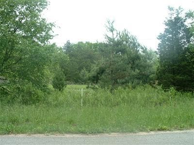
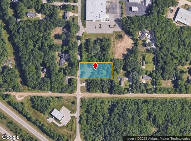
Property Record
S Dangl Rd, Fruitport, MI 49415
NEARBY LISTINGS FOR SALE OR LEASE
Property Detail
S Dangl Rd
15-124-300-0017-00
FRUITPORT CHARTER TOWNSHIP SEC 24 T9N R16W COMM SW COR SD SEC TH N 150.03 FT FOR POB: TH N 150 FT TH N 90D E 300 FT TH S 150
Commercialacreage
Muskegon
X
Michigan
26121C0293E
1.03 AC
2024
Norton Shores
2025
West Michigan
002800
Muskegon, MI
DEMOGRAPHICS near S Dangl Rd
1 Mile
3 Mile
5 Mile
2024 Total Population
1,455
15,212
43,500
2029 Population
1,493
15,403
44,398
Pop Growth 2024-2029
+ 2.61%
+ 1.26%
+ 2.06%
Average Age
45
42
42
2024 Total Households
586
5,983
17,477
HH Growth 2024-2029
+ 2.73%
+ 1.32%
+ 2.15%
Median Household Inc
$70,416
$72,648
$62,675
Avg Household Size
2.40
2.50
2.40
2024 Avg HH Vehicles
2.00
2.00
2.00
Median Home Value
$220,639
$207,972
$198,279
Median Year Built
1996
1984
1981
Nearby Places
Map Layers
Map Styles
 Street
 Aerial
- Restaurants
- Banks
- Shops
- Fitness
- Groceries
Nearby Properties
Address
Land Use
TOTAL SIZE
Lot Size
Zoning
Address
Land Use
TOTAL SIZE
Lot Size
Zoning
350,077 SF
41.42 AC
PUD
Address
Land Use
TOTAL SIZE
Lot Size
Zoning
273,059 SF
30.59 AC
PUD
Address
Land Use
TOTAL SIZE
Lot Size
Zoning
207,571 SF
22 AC
LI
Address
Land Use
TOTAL SIZE
Lot Size
Zoning
65,152 SF
9.77 AC
PUD
Address
Land Use
TOTAL SIZE
Lot Size
Zoning
147,000 SF
GI
Address
Land Use
TOTAL SIZE
Lot Size
Zoning
237,612 SF
13.40 AC
PUD
Address
Land Use
TOTAL SIZE
Lot Size
Zoning
55,600 SF
LI
Address
Land Use
TOTAL SIZE
Lot Size
Zoning
250,000 SF
19.08 AC
GI
Address
Land Use
TOTAL SIZE
Lot Size
Zoning
275,714 SF
17.26 AC
PUD
Address
Land Use
TOTAL SIZE
Lot Size
Zoning
250,000 SF
15.60 AC
GI
Address
Land Use
TOTAL SIZE
Lot Size
Zoning
169,420 SF
15.20 AC
PUD
Address
Land Use
TOTAL SIZE
Lot Size
Zoning
149,707 SF
35.72 AC
GI
Address
Land Use
TOTAL SIZE
Lot Size
Zoning
91,682 SF
21.93 AC
PUD
Address
Land Use
TOTAL SIZE
Lot Size
Zoning
125,059 SF
10.47 AC
PUD
Address
Land Use
TOTAL SIZE
Lot Size
Zoning
117,950 SF
10 AC
GI
Address
Land Use
TOTAL SIZE
Lot Size
Zoning
106,000 SF
GI
Address
Land Use
TOTAL SIZE
Lot Size
Zoning
118,532 SF
8.16 AC
REC
Address
Land Use
TOTAL SIZE
Lot Size
Zoning
63,512 SF
6.22 AC
PUD
Address
Land Use
TOTAL SIZE
Lot Size
Zoning
215,706 SF
23.21 AC
PUD
Address
Land Use
TOTAL SIZE
Lot Size
Zoning
50,252 SF
6.94 AC
C-2
Address
Land Use
TOTAL SIZE
Lot Size
Zoning
356,647 SF
53.83 AC
PUD
Address
Land Use
TOTAL SIZE
Lot Size
Zoning
65,204 SF
2.43 AC
PUD
Address
Land Use
TOTAL SIZE
Lot Size
Zoning
81,600 SF
10.30 AC
GI
Address
Land Use
TOTAL SIZE
Lot Size
Zoning
250,000 SF
17.53 AC
GI
Address
Land Use
TOTAL SIZE
Lot Size
Zoning
250,000 SF
18.72 AC
GI
Address
Land Use
TOTAL SIZE
Lot Size
Zoning
378,727 SF
44.76 AC
B-2
Address
Land Use
TOTAL SIZE
Lot Size
Zoning
158,430 SF
9.23 AC
GI
Address
Land Use
TOTAL SIZE
Lot Size
Zoning
54,100 SF
6.60 AC
PUD
Address
Land Use
TOTAL SIZE
Lot Size
Zoning
88,970 SF
6.46 AC
PUD
Address
Land Use
TOTAL SIZE
Lot Size
Zoning
25,250 SF
2.81 AC
PUD
The World's #1 Commercial Real Estate Marketplace
Connect with us
© 2025 CoStar Group
The information above has been obtained from sources believed reliable. While we do not doubt its accuracy we have not verified it and make no guarantee, warranty or representation about it. It is your responsibility to independently confirm its accuracy and completeness. Any projections, opinions, assumptions, or estimates used are for example only and do not represent the current or future performance of the property. The value of this transaction to you depends on tax and other factors which should be evaluated by your tax, financial, and legal advisors. You and your advisors should conduct a careful, independent investigation of the property to determine to your satisfaction the suitability of the property for your needs.