Property Record
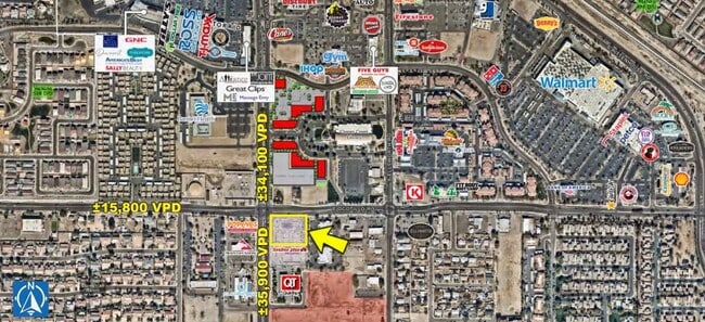
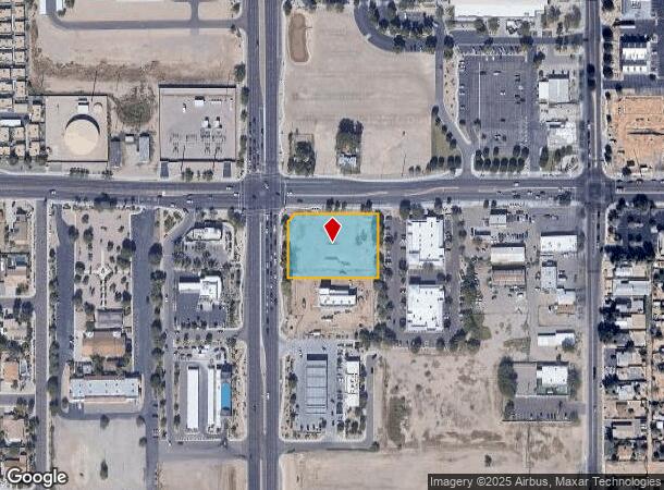
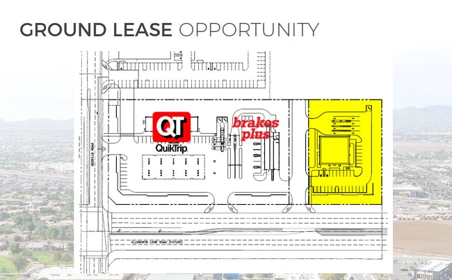
S Ellsworth At East Ocotillo Rd, Queen Creek, AZ 85142
NEARBY LISTINGS FOR SALE OR LEASE
Property Detail
S Ellsworth At East Ocotillo Rd
Phoenix-Mesa-Scottsdale, AZ
Town Of Queen Creek Parcel A Lot Tie
314-03-946
TOWN OF QUEEN CREEK PARCEL A LOT TIE MCR 1365-14
Commercialacreage
Maricopa
X
Arizona
04013C3135L
1
2025
1.18 AC
2025
Gateway Airport/Loop 202
817000
Phoenix
DEMOGRAPHICS near S Ellsworth At East Ocotillo Rd
1 Mile
3 Mile
5 Mile
2024 Total Population
11,915
55,117
160,129
2029 Population
13,056
60,439
184,267
Pop Growth 2024-2029
+ 9.58%
+ 9.66%
+ 15.07%
Average Age
34
35
36
2024 Total Households
3,529
15,903
49,216
HH Growth 2024-2029
+ 9.66%
+ 9.76%
+ 15.24%
Median Household Inc
$107,319
$123,953
$110,433
Avg Household Size
3.30
3.40
3.20
2024 Avg HH Vehicles
2.00
2.00
2.00
Median Home Value
$449,479
$488,284
$438,833
Median Year Built
2008
2010
2009
Nearby Places
Map Layers
Map Styles
 Street
 Aerial
- Restaurants
- Banks
- Shops
- Fitness
- Groceries
PUBLIC TRANSPORTATION
AIRPORT
Phoenix-Mesa Gateway
DRIVE
WALK
Distance
Phoenix-Mesa Gateway
10 min
5.2 mi
Phoenix Sky Harbor International
DRIVE
WALK
Distance
Phoenix Sky Harbor International
49 min
34.4 mi
SALE & LEASE HISTORY
LISTING DATE
SALE/LEASE

Nov 08, 2019
For Lease
Mar 30, 2021
For Lease
Mar 30, 2021
For Sale
Mar 06, 2024
For Lease
Nearby Properties
Address
Land Use
TOTAL SIZE
Lot Size
Zoning
Address
Land Use
TOTAL SIZE
Lot Size
Zoning
64.72 AC
LI
Address
Land Use
TOTAL SIZE
Lot Size
Zoning
1,200,340 SF
85.82 AC
Address
Land Use
TOTAL SIZE
Lot Size
Zoning
32,858 SF
13.76 AC
C-G
Address
Land Use
TOTAL SIZE
Lot Size
Zoning
53,995 SF
10.12 AC
Address
Land Use
TOTAL SIZE
Lot Size
Zoning
477,934 SF
24.18 AC
MU
Address
Land Use
TOTAL SIZE
Lot Size
Zoning
227,555 SF
53.44 AC
R-43
Address
Land Use
TOTAL SIZE
Lot Size
Zoning
225,990 SF
26.23 AC
I-1
Address
Land Use
TOTAL SIZE
Lot Size
Zoning
21,010 SF
2.72 AC
I-1
Address
Land Use
TOTAL SIZE
Lot Size
Zoning
20,053 SF
3.86 AC
R-43
Address
Land Use
TOTAL SIZE
Lot Size
Zoning
139,348 SF
16.39 AC
R-12
Address
Land Use
TOTAL SIZE
Lot Size
Zoning
187,208 SF
34.75 AC
MDR
Address
Land Use
TOTAL SIZE
Lot Size
Zoning
269,550 SF
63.63 AC
Address
Land Use
TOTAL SIZE
Lot Size
Zoning
6.02 AC
I-1
Address
Land Use
TOTAL SIZE
Lot Size
Zoning
420,631 SF
23.19 AC
Address
Land Use
TOTAL SIZE
Lot Size
Zoning
121,297 SF
27.91 AC
Address
Land Use
TOTAL SIZE
Lot Size
Zoning
270,126 SF
12.65 AC
C-TC
Address
Land Use
TOTAL SIZE
Lot Size
Zoning
163,373 SF
16.44 AC
MDR
Address
Land Use
TOTAL SIZE
Lot Size
Zoning
127,184 SF
14.80 AC
R-43
Address
Land Use
TOTAL SIZE
Lot Size
Zoning
117,552 SF
30.35 AC
R143
Address
Land Use
TOTAL SIZE
Lot Size
Zoning
110,880 SF
4.03 AC
R-C
Address
Land Use
TOTAL SIZE
Lot Size
Zoning
216,568 SF
22.18 AC
C-G
Address
Land Use
TOTAL SIZE
Lot Size
Zoning
89,669 SF
13.60 AC
C-G
Address
Land Use
TOTAL SIZE
Lot Size
Zoning
95,413 SF
11.30 AC
R-43
Address
Land Use
TOTAL SIZE
Lot Size
Zoning
100,758 SF
12.30 AC
R-7
Address
Land Use
TOTAL SIZE
Lot Size
Zoning
179,893 SF
15 AC
C-G
Address
Land Use
TOTAL SIZE
Lot Size
Zoning
112,277 SF
9.68 AC
C-TC
Address
Land Use
TOTAL SIZE
Lot Size
Zoning
101,394 SF
8.70 AC
MDR
Address
Land Use
TOTAL SIZE
Lot Size
Zoning
152,901 SF
19.45 AC
Address
Land Use
TOTAL SIZE
Lot Size
Zoning
69,001 SF
16.70 AC
DC
Address
Land Use
TOTAL SIZE
Lot Size
Zoning
3.34 AC
I-1
The World's #1 Commercial Real Estate Marketplace
Connect with us
© 2025 CoStar Group
The information above has been obtained from sources believed reliable. While we do not doubt its accuracy we have not verified it and make no guarantee, warranty or representation about it. It is your responsibility to independently confirm its accuracy and completeness. Any projections, opinions, assumptions, or estimates used are for example only and do not represent the current or future performance of the property. The value of this transaction to you depends on tax and other factors which should be evaluated by your tax, financial, and legal advisors. You and your advisors should conduct a careful, independent investigation of the property to determine to your satisfaction the suitability of the property for your needs.