Property Record
S Fairlea, Lewisburg, WV 24901

NEARBY LISTINGS FOR SALE OR LEASE
-
-
View all Lewisburg listings for sale on LoopNet.com
Property Detail
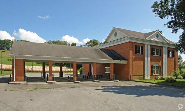
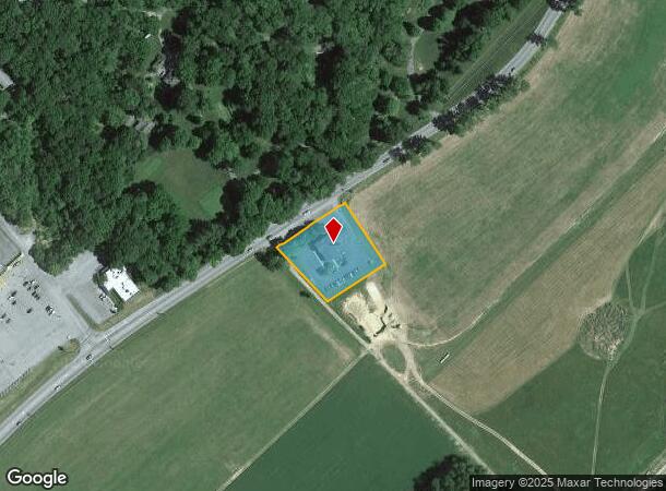
S Fairlea
09 2400940001
.893 AC RSVY US RT 219 HOME CARE PLUS LOCATION
Financialbuilding
Greenbrier
X
West Virginia
54025C0640E
0.89 AC
2025
West Virginia South Area
2025
Other Market Areas
950600
DEMOGRAPHICS near S Fairlea
1 Mile
3 Mile
5 Mile
2024 Total Population
2,935
7,990
12,832
2029 Population
2,913
7,912
12,670
Pop Growth 2024-2029
(0.75%)
(0.98%)
(1.26%)
Average Age
46
45
45
2024 Total Households
1,409
3,738
5,782
HH Growth 2024-2029
(0.85%)
(1.04%)
(1.31%)
Median Household Inc
$37,469
$37,780
$40,615
Avg Household Size
2.00
2.10
2.20
2024 Avg HH Vehicles
1.00
2.00
2.00
Median Home Value
$154,228
$202,332
$178,571
Median Year Built
1977
1978
1978
Nearby Places
Map Layers
Map Styles
 Street
 Aerial
- Restaurants
- Banks
- Shops
- Fitness
- Groceries
PUBLIC TRANSPORTATION
COMMUTER RAIL
White Sulphur Springs Amtrak (Cardinal - Amtrak)
DRIVE
WALK
Distance
White Sulphur Springs Amtrak (Cardinal - Amtrak)
15 min
9.9 mi
Freight Ports
Virginia Port Authority - Richmond
DRIVE
WALK
Distance
Virginia Port Authority - Richmond
241 min
214.7 mi
Nearby Properties
Address
Land Use
TOTAL SIZE
Lot Size
Zoning
Address
Land Use
TOTAL SIZE
Lot Size
Zoning
9.68 AC
Address
Land Use
TOTAL SIZE
Lot Size
Zoning
18.59 AC
Address
Land Use
TOTAL SIZE
Lot Size
Zoning
221.97 AC
Address
Land Use
TOTAL SIZE
Lot Size
Zoning
12.91 AC
Address
Land Use
TOTAL SIZE
Lot Size
Zoning
3.68 AC
Address
Land Use
TOTAL SIZE
Lot Size
Zoning
1.98 AC
Address
Land Use
TOTAL SIZE
Lot Size
Zoning
5.06 AC
Address
Land Use
TOTAL SIZE
Lot Size
Zoning
21.21 AC
Address
Land Use
TOTAL SIZE
Lot Size
Zoning
4.86 AC
Address
Land Use
TOTAL SIZE
Lot Size
Zoning
3.80 AC
Address
Land Use
TOTAL SIZE
Lot Size
Zoning
2.53 AC
Address
Land Use
TOTAL SIZE
Lot Size
Zoning
4.81 AC
Address
Land Use
TOTAL SIZE
Lot Size
Zoning
4.61 AC
Address
Land Use
TOTAL SIZE
Lot Size
Zoning
6.07 AC
Address
Land Use
TOTAL SIZE
Lot Size
Zoning
3.26 AC
Address
Land Use
TOTAL SIZE
Lot Size
Zoning
3.39 AC
Address
Land Use
TOTAL SIZE
Lot Size
Zoning
Address
Land Use
TOTAL SIZE
Lot Size
Zoning
Address
Land Use
TOTAL SIZE
Lot Size
Zoning
Address
Land Use
TOTAL SIZE
Lot Size
Zoning
2.50 AC
Address
Land Use
TOTAL SIZE
Lot Size
Zoning
0.77 AC
Address
Land Use
TOTAL SIZE
Lot Size
Zoning
1.67 AC
Address
Land Use
TOTAL SIZE
Lot Size
Zoning
36.45 AC
Address
Land Use
TOTAL SIZE
Lot Size
Zoning
1.54 AC
Address
Land Use
TOTAL SIZE
Lot Size
Zoning
0.19 AC
Address
Land Use
TOTAL SIZE
Lot Size
Zoning
Address
Land Use
TOTAL SIZE
Lot Size
Zoning
1.62 AC
Address
Land Use
TOTAL SIZE
Lot Size
Zoning
0.51 AC
Address
Land Use
TOTAL SIZE
Lot Size
Zoning
The World's #1 Commercial Real Estate Marketplace
Connect with us
© 2026 CoStar Group
The information above has been obtained from sources believed reliable. While we do not doubt its accuracy we have not verified it and make no guarantee, warranty or representation about it. It is your responsibility to independently confirm its accuracy and completeness. Any projections, opinions, assumptions, or estimates used are for example only and do not represent the current or future performance of the property. The value of this transaction to you depends on tax and other factors which should be evaluated by your tax, financial, and legal advisors. You and your advisors should conduct a careful, independent investigation of the property to determine to your satisfaction the suitability of the property for your needs.