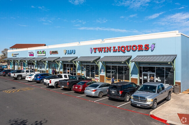
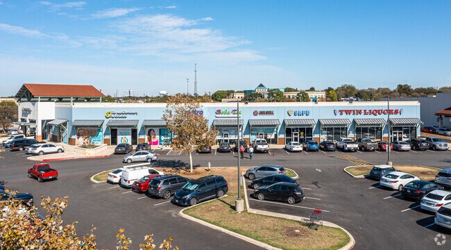
Property Record
S Gevers St, San Antonio, TX 78223
NEARBY LISTINGS FOR SALE OR LEASE
Property Detail
S Gevers St
San Antonio-New Braunfels, TX
Ncb 7589 Heb Mccreless
07589-000-0203
NCB 7589 N IRR 387.59 FT OF LOT 20 NON ADJ (HEB MCCRELESS RETAIL) 2019 SPLIT PER SURVEY CR 45901 2018-NEW PER PLAT 9723/20-26 FILED 10-13-17-2017, THEN SPLIT PER REQUEST. JLF/GIS/11-14-2017 & 1-4-2018
Regionalshoppingcenterormallwithanchorstore
Bexar
X
Texas
48029C0415G
16
2024
4.90 AC
2025
South
192200
San Antonio
16,327 SF
DEMOGRAPHICS near S Gevers St
1 Mile
3 Mile
5 Mile
2024 Total Population
17,987
117,685
285,191
2029 Population
19,066
126,142
305,280
Pop Growth 2024-2029
+ 6.00%
+ 7.19%
+ 7.04%
Average Age
39
38
37
2024 Total Households
6,709
43,145
102,027
HH Growth 2024-2029
+ 6.13%
+ 7.36%
+ 7.43%
Median Household Inc
$42,572
$39,388
$41,294
Avg Household Size
2.60
2.60
2.60
2024 Avg HH Vehicles
2.00
2.00
2.00
Median Home Value
$130,037
$137,039
$135,941
Median Year Built
1955
1959
1964
Nearby Places
Map Layers
Map Styles
 Street
 Aerial
- Restaurants
- Banks
- Shops
- Fitness
- Groceries
PUBLIC TRANSPORTATION
COMMUTER RAIL
San Antonio Amtrak Station (Sunset Limited - Amtrak, Texas Eagle - Amtrak)
DRIVE
WALK
Distance
San Antonio Amtrak Station (Sunset Limited - Amtrak, Texas Eagle - Amtrak)
6 min
3.9 mi
AIRPORT
San Antonio International
DRIVE
WALK
Distance
San Antonio International
16 min
11.8 mi
Freight Ports
Calhoun Port
DRIVE
WALK
Distance
Calhoun Port
179 min
144.9 mi
SALE & LEASE HISTORY
LISTING DATE
SALE/LEASE

Dec 15, 2016
For Lease
Nearby Properties
Address
Land Use
TOTAL SIZE
Lot Size
Zoning
Address
Land Use
TOTAL SIZE
Lot Size
Zoning
220,079 SF
28.12 AC
Address
Land Use
TOTAL SIZE
Lot Size
Zoning
348,974 SF
20.98 AC
Address
Land Use
TOTAL SIZE
Lot Size
Zoning
14,492 SF
6.62 AC
Address
Land Use
TOTAL SIZE
Lot Size
Zoning
291,374 SF
13.49 AC
Address
Land Use
TOTAL SIZE
Lot Size
Zoning
250,400 SF
20.55 AC
Address
Land Use
TOTAL SIZE
Lot Size
Zoning
61,085 SF
16.73 AC
Address
Land Use
TOTAL SIZE
Lot Size
Zoning
197,115 SF
2.29 AC
Address
Land Use
TOTAL SIZE
Lot Size
Zoning
158,546 SF
6.45 AC
Address
Land Use
TOTAL SIZE
Lot Size
Zoning
211,200 SF
7.49 AC
Address
Land Use
TOTAL SIZE
Lot Size
Zoning
273,370 SF
11.93 AC
Address
Land Use
TOTAL SIZE
Lot Size
Zoning
12,504,292 SF
32.18 AC
Address
Land Use
TOTAL SIZE
Lot Size
Zoning
187,369 SF
5.69 AC
Address
Land Use
TOTAL SIZE
Lot Size
Zoning
245,745 SF
11.99 AC
Address
Land Use
TOTAL SIZE
Lot Size
Zoning
174,316 SF
15.38 AC
Address
Land Use
TOTAL SIZE
Lot Size
Zoning
88,420 SF
7.62 AC
Address
Land Use
TOTAL SIZE
Lot Size
Zoning
353,148 SF
14.10 AC
Address
Land Use
TOTAL SIZE
Lot Size
Zoning
148,525 SF
30.72 AC
Address
Land Use
TOTAL SIZE
Lot Size
Zoning
163.70 AC
Address
Land Use
TOTAL SIZE
Lot Size
Zoning
63,850 SF
33.42 AC
Address
Land Use
TOTAL SIZE
Lot Size
Zoning
145,389 SF
18.70 AC
Address
Land Use
TOTAL SIZE
Lot Size
Zoning
193,243 SF
9.03 AC
Address
Land Use
TOTAL SIZE
Lot Size
Zoning
221,760 SF
7.22 AC
Address
Land Use
TOTAL SIZE
Lot Size
Zoning
372,078 SF
10.95 AC
Address
Land Use
TOTAL SIZE
Lot Size
Zoning
148,672 SF
11.84 AC
Address
Land Use
TOTAL SIZE
Lot Size
Zoning
332,148 SF
17.75 AC
Address
Land Use
TOTAL SIZE
Lot Size
Zoning
87,686 SF
32.01 AC
Address
Land Use
TOTAL SIZE
Lot Size
Zoning
79,740 SF
0.60 AC
Address
Land Use
TOTAL SIZE
Lot Size
Zoning
186,995 SF
14.18 AC
Address
Land Use
TOTAL SIZE
Lot Size
Zoning
144,692 SF
10.83 AC
Address
Land Use
TOTAL SIZE
Lot Size
Zoning
20.58 AC
The World's #1 Commercial Real Estate Marketplace
Connect with us
© 2025 CoStar Group
The information above has been obtained from sources believed reliable. While we do not doubt its accuracy we have not verified it and make no guarantee, warranty or representation about it. It is your responsibility to independently confirm its accuracy and completeness. Any projections, opinions, assumptions, or estimates used are for example only and do not represent the current or future performance of the property. The value of this transaction to you depends on tax and other factors which should be evaluated by your tax, financial, and legal advisors. You and your advisors should conduct a careful, independent investigation of the property to determine to your satisfaction the suitability of the property for your needs.