Property Record
S High St, Belleville, IL 62220
Property Detail
S High St
St. Louis, MO-IL
ABENDS SOUTH BELLEVILLE LOT/SEC-163 W 160 FT OF LTS 162 163 164 & W 160 FT OF S 10 FT OF LT 165 A02683529
08-27.0-306-008
ST. CLAIR
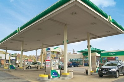
Conveniencestore
Illinois
2024
162,165
2024
0.53 AC
504354
Metro East Illinois
2,340 SF
St. Louis
NEARBY LISTINGS FOR SALE OR LEASE
DEMOGRAPHICS near S High St
1 mile
3 mile
5 mile
2025 Total Population
7,324
39,820
76,999
2030 Population
7,236
39,045
75,105
Pop Growth 2025-2030
(1.20%)
(1.95%)
(2.46%)
Average Age
40
41
41
2025 Total Households
2,996
16,880
32,386
HH Growth 2025-2030
(1.10%)
(1.94%)
(2.47%)
Median Household Inc
$59,147
$58,748
$69,770
Avg Household Size
2.20
2.20
2.30
2025 Avg HH Vehicles
2.00
2.00
2.00
Median Home Value
$136,639
$145,994
$181,220
Median Year Built
1955
1962
1974
Nearby Places
Map Layers
Map Styles
 Street
 Aerial
Layers
 Traffic
 Biking
Places
Listings with unknown addresses are not visible on the map
- Restaurants
- Banks
- Shops
- Fitness
- Groceries
PUBLIC TRANSPORTATION
COMMUTER RAIL
Belleville (Lambert Airport Shiloh-Scott - St. Louis MetroLink (MetroLink))
Drive
Walk
Distance
Belleville (Lambert Airport Shiloh-Scott - St. Louis MetroLink (MetroLink))
4 min
2.0 mi
Swansea (Lambert Airport Shiloh-Scott - St. Louis MetroLink (MetroLink))
Drive
Walk
Distance
Swansea (Lambert Airport Shiloh-Scott - St. Louis MetroLink (MetroLink))
5 min
2.7 mi
AIRPORT
Scott AFB/Midamerica St Louis
Drive
Walk
Distance
Scott AFB/Midamerica St Louis
23 min
11.6 mi
St Louis Lambert International
Drive
Walk
Distance
St Louis Lambert International
41 min
29.0 mi
Freight Ports
Port Milwaukee
Drive
Walk
Distance
Port Milwaukee
422 min
369.1 mi
SALE & LEASE HISTORY
LISTING DATE
SALE/LEASE

Sep 24, 2016
For Sale
Nearby Properties
Address
Land Use
TOTAL SIZE
Lot Size
Zoning
Address
Land Use
TOTAL SIZE
Lot Size
Zoning
3,388 SF
22.25 AC
Address
Land Use
TOTAL SIZE
Lot Size
Zoning
20,522 SF
6.42 AC
Address
Land Use
TOTAL SIZE
Lot Size
Zoning
41,366 SF
12.07 AC
Address
Land Use
TOTAL SIZE
Lot Size
Zoning
104,230 SF
11.08 AC
Address
Land Use
TOTAL SIZE
Lot Size
Zoning
Address
Land Use
TOTAL SIZE
Lot Size
Zoning
19,576 SF
22.78 AC
Address
Land Use
TOTAL SIZE
Lot Size
Zoning
126,937 SF
11.98 AC
Address
Land Use
TOTAL SIZE
Lot Size
Zoning
13,546 SF
11.19 AC
Address
Land Use
TOTAL SIZE
Lot Size
Zoning
86,482 SF
8 AC
Address
Land Use
TOTAL SIZE
Lot Size
Zoning
155,488 SF
16.54 AC
Address
Land Use
TOTAL SIZE
Lot Size
Zoning
15,839 SF
5.96 AC
Address
Land Use
TOTAL SIZE
Lot Size
Zoning
26,233 SF
17.61 AC
Address
Land Use
TOTAL SIZE
Lot Size
Zoning
88,468 SF
10.48 AC
Address
Land Use
TOTAL SIZE
Lot Size
Zoning
4,818 SF
3.64 AC
Address
Land Use
TOTAL SIZE
Lot Size
Zoning
23,951 SF
0.89 AC
Address
Land Use
TOTAL SIZE
Lot Size
Zoning
4,400 SF
2.56 AC
Address
Land Use
TOTAL SIZE
Lot Size
Zoning
30,000 SF
9.05 AC
Address
Land Use
TOTAL SIZE
Lot Size
Zoning
8,208 SF
1.58 AC
Address
Land Use
TOTAL SIZE
Lot Size
Zoning
38,259 SF
7.80 AC
Address
Land Use
TOTAL SIZE
Lot Size
Zoning
12,010 SF
2.49 AC
Address
Land Use
TOTAL SIZE
Lot Size
Zoning
47,369 SF
4.17 AC
Address
Land Use
TOTAL SIZE
Lot Size
Zoning
12.99 AC
Address
Land Use
TOTAL SIZE
Lot Size
Zoning
45,394 SF
4.13 AC
Address
Land Use
TOTAL SIZE
Lot Size
Zoning
36,445 SF
6.07 AC
Address
Land Use
TOTAL SIZE
Lot Size
Zoning
5,872 SF
1.15 AC
Address
Land Use
TOTAL SIZE
Lot Size
Zoning
52,232 SF
4.06 AC
Address
Land Use
TOTAL SIZE
Lot Size
Zoning
30,779 SF
3.26 AC
Address
Land Use
TOTAL SIZE
Lot Size
Zoning
2.98 AC
Address
Land Use
TOTAL SIZE
Lot Size
Zoning
3,456 SF
5.99 AC
Address
Land Use
TOTAL SIZE
Lot Size
Zoning
81,860 SF
7.62 AC
The World's #1 Commercial Real Estate Marketplace
Connect with us
© 2026 CoStar Group
The information above has been obtained from sources believed reliable. While we do not doubt its accuracy we have not verified it and make no guarantee, warranty or representation about it. It is your responsibility to independently confirm its accuracy and completeness. Any projections, opinions, assumptions, or estimates used are for example only and do not represent the current or future performance of the property. The value of this transaction to you depends on tax and other factors which should be evaluated by your tax, financial, and legal advisors. You and your advisors should conduct a careful, independent investigation of the property to determine to your satisfaction the suitability of the property for your needs.