Property Record
Us Highway 27, Clermont, FL 34711
NEARBY LISTINGS FOR SALE OR LEASE
Property Detail
Us Highway 27
Orlando-Kissimmee-Sanford, FL
Clermont Lake Highlands
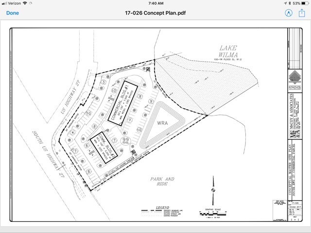
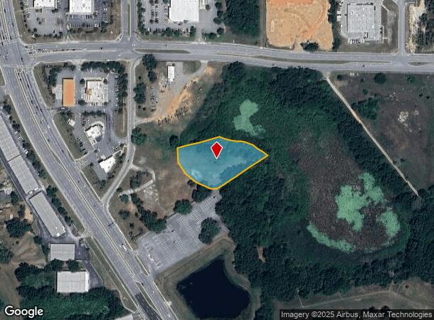
09-22-26-1305-40B-00002
CLERMONT LAKE HIGHLANDS 29-22-26 BEG AT THE INTERSECTION OF W LINE OF SEC 29 & ELY R/W LINE OF SR 27 RUN S 32-55-0 E ALONG SAID R/W LINE 46 FT N 57-05-0 E TO SHORELINE OF LAKE WILMA & PT A BACK TO POB RUN N ALONG W LINE OF SAID SEC 29 A DIST OF 356.1
Commercialacreage
Lake
AE
Florida
12095C0200H
1.57 AC
2024
Lake County
2026
Orlando
031315
DEMOGRAPHICS near Us Highway 27
1 Mile
3 Mile
5 Mile
2024 Total Population
5,935
52,897
101,881
2029 Population
6,831
61,444
119,359
Pop Growth 2024-2029
+ 15.10%
+ 16.16%
+ 17.16%
Average Age
40
42
42
2024 Total Households
2,321
20,211
37,646
HH Growth 2024-2029
+ 14.95%
+ 15.96%
+ 16.91%
Median Household Inc
$70,714
$78,494
$83,312
Avg Household Size
2.50
2.60
2.70
2024 Avg HH Vehicles
2.00
2.00
2.00
Median Home Value
$227,440
$311,808
$321,417
Median Year Built
1992
2002
2004
Nearby Places
Map Layers
Map Styles
 Street
 Aerial
- Restaurants
- Banks
- Shops
- Fitness
- Groceries
PUBLIC TRANSPORTATION
AIRPORT
Orlando International
DRIVE
WALK
Distance
Orlando International
45 min
33.0 mi
Freight Ports
Port of Tampa Bay
DRIVE
WALK
Distance
Port of Tampa Bay
99 min
74.7 mi
SALE & LEASE HISTORY
LISTING DATE
SALE/LEASE

Oct 16, 2017
For Sale
Nearby Properties
Address
Land Use
TOTAL SIZE
Lot Size
Zoning
Address
Land Use
TOTAL SIZE
Lot Size
Zoning
403,970 SF
30.99 AC
PUD
Address
Land Use
TOTAL SIZE
Lot Size
Zoning
285,581 SF
19.34 AC
CFD
Address
Land Use
TOTAL SIZE
Lot Size
Zoning
326,899 SF
20.77 AC
Address
Land Use
TOTAL SIZE
Lot Size
Zoning
299,214 SF
25.01 AC
PUD
Address
Land Use
TOTAL SIZE
Lot Size
Zoning
321,012 SF
22.55 AC
PUD
Address
Land Use
TOTAL SIZE
Lot Size
Zoning
2,000 SF
35.96 AC
PUD
Address
Land Use
TOTAL SIZE
Lot Size
Zoning
269,594 SF
25.23 AC
PUD
Address
Land Use
TOTAL SIZE
Lot Size
Zoning
179,290 SF
23.79 AC
Address
Land Use
TOTAL SIZE
Lot Size
Zoning
212,649 SF
4.20 AC
Address
Land Use
TOTAL SIZE
Lot Size
Zoning
192,907 SF
16.43 AC
PUD
Address
Land Use
TOTAL SIZE
Lot Size
Zoning
2,000 SF
26.79 AC
PUD
Address
Land Use
TOTAL SIZE
Lot Size
Zoning
273,592 SF
91.55 AC
R6
Address
Land Use
TOTAL SIZE
Lot Size
Zoning
Address
Land Use
TOTAL SIZE
Lot Size
Zoning
53,054 SF
11.65 AC
Address
Land Use
TOTAL SIZE
Lot Size
Zoning
52,986 SF
18.27 AC
Address
Land Use
TOTAL SIZE
Lot Size
Zoning
2,000 SF
30.62 AC
CFD
Address
Land Use
TOTAL SIZE
Lot Size
Zoning
2,000 SF
63.78 AC
Address
Land Use
TOTAL SIZE
Lot Size
Zoning
106,799 SF
9.06 AC
MP
Address
Land Use
TOTAL SIZE
Lot Size
Zoning
124,634 SF
18.57 AC
Address
Land Use
TOTAL SIZE
Lot Size
Zoning
142,824 SF
9.90 AC
C2
Address
Land Use
TOTAL SIZE
Lot Size
Zoning
126,067 SF
9.34 AC
Address
Land Use
TOTAL SIZE
Lot Size
Zoning
62,794 SF
2.31 AC
Address
Land Use
TOTAL SIZE
Lot Size
Zoning
153,522 SF
29.72 AC
PUD
Address
Land Use
TOTAL SIZE
Lot Size
Zoning
203,762 SF
18.28 AC
R1
Address
Land Use
TOTAL SIZE
Lot Size
Zoning
227,034 SF
29.20 AC
Address
Land Use
TOTAL SIZE
Lot Size
Zoning
109,254 SF
5.54 AC
Address
Land Use
TOTAL SIZE
Lot Size
Zoning
95,182 SF
12.34 AC
PUD
Address
Land Use
TOTAL SIZE
Lot Size
Zoning
102,086 SF
5.32 AC
Address
Land Use
TOTAL SIZE
Lot Size
Zoning
158,351 SF
19.10 AC
C2
Address
Land Use
TOTAL SIZE
Lot Size
Zoning
178,735 SF
20.68 AC
PUD
The World's #1 Commercial Real Estate Marketplace
Connect with us
© 2025 CoStar Group
The information above has been obtained from sources believed reliable. While we do not doubt its accuracy we have not verified it and make no guarantee, warranty or representation about it. It is your responsibility to independently confirm its accuracy and completeness. Any projections, opinions, assumptions, or estimates used are for example only and do not represent the current or future performance of the property. The value of this transaction to you depends on tax and other factors which should be evaluated by your tax, financial, and legal advisors. You and your advisors should conduct a careful, independent investigation of the property to determine to your satisfaction the suitability of the property for your needs.