Property Record
S Highway 39, Mount Vernon, MO 65712
NEARBY LISTINGS FOR SALE OR LEASE
-
-
View all Mount Vernon listings for sale on LoopNet.com
Property Detail
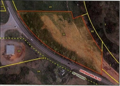
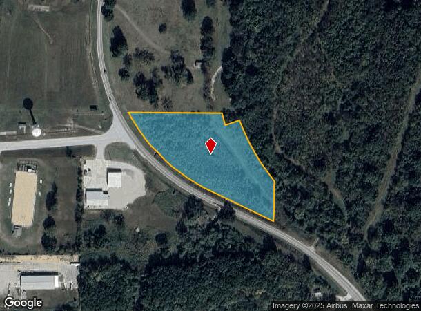
S Highway 39
08-7.0-25-000-000-021.000
ALL THAT PART OF THE N1/2 OF THE NW SE LYING E & N OF HWY 39 R/W, W & S OF ABAND R/R R/W ALSO, THE W50' OF THE R/R R/W (DESC AS FOLLOWS: BEG AT THE POINT WHERE THE CENTER LINE OF R/W INTERSECTS THE E LINE OF THE NW SE, THEN MEAS NW ALONG THE CENTER
Residentialacreage
Lawrence
X
Missouri
29109C0302D
3.71 AC
2024
Missouri South Area
2025
Other Market Areas
470202
DEMOGRAPHICS near S Highway 39
1 Mile
3 Mile
5 Mile
2024 Total Population
2,562
5,980
7,545
2029 Population
2,662
6,180
7,778
Pop Growth 2024-2029
+ 3.90%
+ 3.34%
+ 3.09%
Average Age
40
41
41
2024 Total Households
994
2,343
2,914
HH Growth 2024-2029
+ 4.02%
+ 3.59%
+ 3.26%
Median Household Inc
$51,750
$47,913
$50,426
Avg Household Size
2.40
2.40
2.40
2024 Avg HH Vehicles
2.00
2.00
2.00
Median Home Value
$140,137
$140,585
$148,564
Median Year Built
1987
1982
1983
Nearby Places
Map Layers
Map Styles
 Street
 Aerial
- Restaurants
- Banks
- Shops
- Fitness
- Groceries
PUBLIC TRANSPORTATION
AIRPORT
Springfield-Branson Ntl
DRIVE
WALK
Distance
Springfield-Branson Ntl
49 min
34.9 mi
Nearby Properties
Address
Land Use
TOTAL SIZE
Lot Size
Zoning
Address
Land Use
TOTAL SIZE
Lot Size
Zoning
69,141 SF
10.58 AC
Address
Land Use
TOTAL SIZE
Lot Size
Zoning
72,320 SF
9.91 AC
Address
Land Use
TOTAL SIZE
Lot Size
Zoning
39,092 SF
3.64 AC
Address
Land Use
TOTAL SIZE
Lot Size
Zoning
12,997 SF
2.50 AC
Address
Land Use
TOTAL SIZE
Lot Size
Zoning
13,792 SF
18 AC
Address
Land Use
TOTAL SIZE
Lot Size
Zoning
32,925 SF
6.83 AC
Address
Land Use
TOTAL SIZE
Lot Size
Zoning
15,264 SF
3.34 AC
Address
Land Use
TOTAL SIZE
Lot Size
Zoning
12,855 SF
2.91 AC
Address
Land Use
TOTAL SIZE
Lot Size
Zoning
13,120 SF
0.71 AC
Address
Land Use
TOTAL SIZE
Lot Size
Zoning
4,995 SF
2.20 AC
Address
Land Use
TOTAL SIZE
Lot Size
Zoning
7,484 SF
0.36 AC
Address
Land Use
TOTAL SIZE
Lot Size
Zoning
12,186 SF
3.60 AC
Address
Land Use
TOTAL SIZE
Lot Size
Zoning
4,240 SF
2.96 AC
Address
Land Use
TOTAL SIZE
Lot Size
Zoning
23,896 SF
4.02 AC
Address
Land Use
TOTAL SIZE
Lot Size
Zoning
4,593 SF
16.13 AC
Address
Land Use
TOTAL SIZE
Lot Size
Zoning
26,092 SF
2.40 AC
Address
Land Use
TOTAL SIZE
Lot Size
Zoning
3,924 SF
1.61 AC
Address
Land Use
TOTAL SIZE
Lot Size
Zoning
3,900 SF
0.62 AC
Address
Land Use
TOTAL SIZE
Lot Size
Zoning
2,050 SF
1.23 AC
Address
Land Use
TOTAL SIZE
Lot Size
Zoning
3,658 SF
1.26 AC
The World's #1 Commercial Real Estate Marketplace
Connect with us
© 2025 CoStar Group
The information above has been obtained from sources believed reliable. While we do not doubt its accuracy we have not verified it and make no guarantee, warranty or representation about it. It is your responsibility to independently confirm its accuracy and completeness. Any projections, opinions, assumptions, or estimates used are for example only and do not represent the current or future performance of the property. The value of this transaction to you depends on tax and other factors which should be evaluated by your tax, financial, and legal advisors. You and your advisors should conduct a careful, independent investigation of the property to determine to your satisfaction the suitability of the property for your needs.