Property Record
S Highway 78, , GA
NEARBY LISTINGS FOR SALE OR LEASE
-
-
View all listings for sale on LoopNet.com
Property Detail
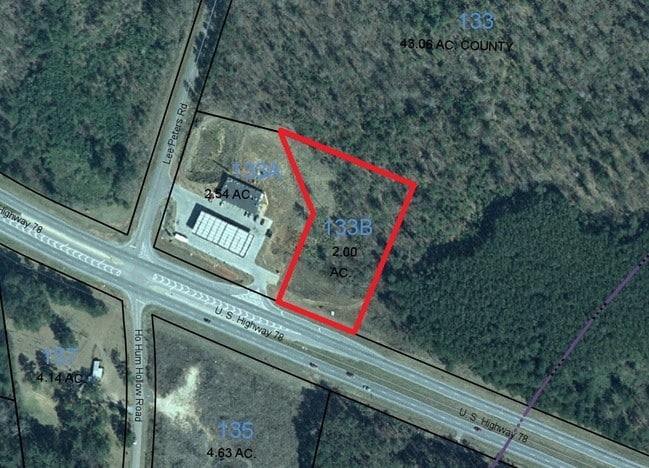
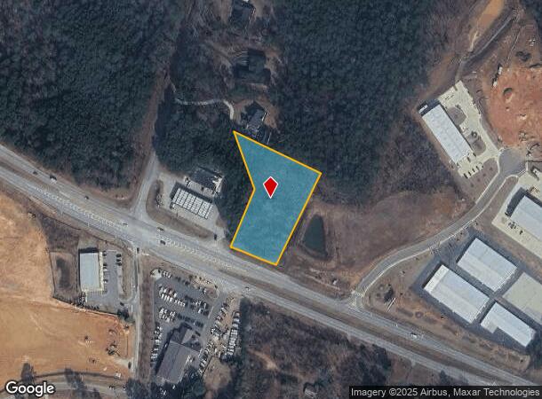
S Highway 78
Atlanta-Sandy Springs-Roswell, GA
09094-Sf-Hwy 78 Major
C061000000133B00
2.00AC
Commercialacreage
Walton
X
Georgia
13297C0105E
2 AC
2024
Walton County
2025
Atlanta
110503
DEMOGRAPHICS near S Highway 78
1 Mile
3 Mile
5 Mile
2024 Total Population
1,475
12,901
42,944
2029 Population
1,694
14,841
49,198
Pop Growth 2024-2029
+ 14.85%
+ 15.04%
+ 14.56%
Average Age
41
41
40
2024 Total Households
489
4,382
14,437
HH Growth 2024-2029
+ 15.34%
+ 15.40%
+ 14.93%
Median Household Inc
$84,274
$85,058
$84,609
Avg Household Size
2.90
2.90
2.90
2024 Avg HH Vehicles
2.00
2.00
2.00
Median Home Value
$304,242
$288,329
$284,797
Median Year Built
1997
1999
1999
Nearby Places
Map Layers
Map Styles
 Street
 Aerial
- Restaurants
- Banks
- Shops
- Fitness
- Groceries
SALE & LEASE HISTORY
LISTING DATE
SALE/LEASE

Sep 24, 2016
For Sale
Aug 15, 2017
For Sale
Aug 12, 2019
For Sale
Nearby Properties
Address
Land Use
TOTAL SIZE
Lot Size
Zoning
Address
Land Use
TOTAL SIZE
Lot Size
Zoning
3,480 SF
57.72 AC
RM8
Address
Land Use
TOTAL SIZE
Lot Size
Zoning
96,129 SF
32.74 AC
A1
Address
Land Use
TOTAL SIZE
Lot Size
Zoning
25,039 SF
3.05 AC
OI
Address
Land Use
TOTAL SIZE
Lot Size
Zoning
4,950 SF
6.96 AC
M1
Address
Land Use
TOTAL SIZE
Lot Size
Zoning
8,640 SF
53 AC
A1
Address
Land Use
TOTAL SIZE
Lot Size
Zoning
8.98 AC
CH
Address
Land Use
TOTAL SIZE
Lot Size
Zoning
12,800 SF
7.36 AC
B3
Address
Land Use
TOTAL SIZE
Lot Size
Zoning
25,300 SF
5.34 AC
B2
Address
Land Use
TOTAL SIZE
Lot Size
Zoning
25,340 SF
7.59 AC
B1
Address
Land Use
TOTAL SIZE
Lot Size
Zoning
9,316 SF
2.40 AC
OI
Address
Land Use
TOTAL SIZE
Lot Size
Zoning
12,000 SF
3 AC
B2
Address
Land Use
TOTAL SIZE
Lot Size
Zoning
6,300 SF
1.64 AC
B2
Address
Land Use
TOTAL SIZE
Lot Size
Zoning
336.93 AC
A1 WP2
Address
Land Use
TOTAL SIZE
Lot Size
Zoning
188.42 AC
B2 R1
Address
Land Use
TOTAL SIZE
Lot Size
Zoning
4,336 SF
3.76 AC
M1
Address
Land Use
TOTAL SIZE
Lot Size
Zoning
10,903 SF
9.92 AC
A1
Address
Land Use
TOTAL SIZE
Lot Size
Zoning
16,450 SF
7.06 AC
B2
Address
Land Use
TOTAL SIZE
Lot Size
Zoning
5,000 SF
5.83 AC
B2
Address
Land Use
TOTAL SIZE
Lot Size
Zoning
8.69 AC
OI
Address
Land Use
TOTAL SIZE
Lot Size
Zoning
18,180 SF
10 AC
A1
Address
Land Use
TOTAL SIZE
Lot Size
Zoning
160.43 AC
R1
Address
Land Use
TOTAL SIZE
Lot Size
Zoning
21,500 SF
2 AC
M1
Address
Land Use
TOTAL SIZE
Lot Size
Zoning
8,135 SF
16.22 AC
B2
Address
Land Use
TOTAL SIZE
Lot Size
Zoning
13,500 SF
2.99 AC
I1
Address
Land Use
TOTAL SIZE
Lot Size
Zoning
9,000 SF
3.69 AC
B3
Address
Land Use
TOTAL SIZE
Lot Size
Zoning
28.01 AC
B2
Address
Land Use
TOTAL SIZE
Lot Size
Zoning
11,000 SF
3 AC
CH
Address
Land Use
TOTAL SIZE
Lot Size
Zoning
6,000 SF
2.81 AC
B2
Address
Land Use
TOTAL SIZE
Lot Size
Zoning
25,067 SF
4.07 AC
B2
Address
Land Use
TOTAL SIZE
Lot Size
Zoning
22.59 AC
B2
The World's #1 Commercial Real Estate Marketplace
Connect with us
© 2026 CoStar Group
The information above has been obtained from sources believed reliable. While we do not doubt its accuracy we have not verified it and make no guarantee, warranty or representation about it. It is your responsibility to independently confirm its accuracy and completeness. Any projections, opinions, assumptions, or estimates used are for example only and do not represent the current or future performance of the property. The value of this transaction to you depends on tax and other factors which should be evaluated by your tax, financial, and legal advisors. You and your advisors should conduct a careful, independent investigation of the property to determine to your satisfaction the suitability of the property for your needs.