Property Record
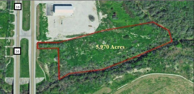
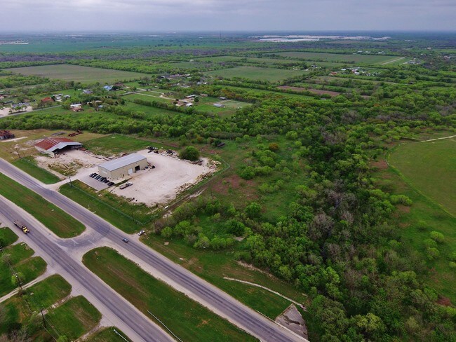
17940 State Highway 16 S, San Antonio, TX 78264

Property Detail
17940 State Highway 16 S
San Antonio-New Braunfels, TX
CB 4201B (LIBERTY LIFT 2 SUBD), BLOCK 2 LOT 3 2017-NEW PER PLAT 9706/97-101 FILED 9-30-16. JLF/GIS/10-24-16
04201-202-0030
BEXAR
Commercialnec
Texas
A Areas with a 1% annual chance of flooding and a 26% chance of flooding over the life of a 30-year mortgage.
1
2024
5.97 AC
2025
South
152100
San Antonio
2,400 SF
NEARBY LISTINGS FOR SALE OR LEASE
DEMOGRAPHICS near 17940 State Highway 16 S
1 mile
3 mile
5 mile
2025 Total Population
428
4,249
17,356
2030 Population
457
4,704
18,981
Pop Growth 2025-2030
+ 6.78%
+ 10.71%
+ 9.36%
Average Age
39
37
36
2025 Total Households
139
1,320
5,257
HH Growth 2025-2030
+ 6.47%
+ 11.14%
+ 9.63%
Median Household Inc
$65,294
$80,221
$70,102
Avg Household Size
3.10
3.10
3.20
2025 Avg HH Vehicles
3.00
2.00
2.00
Median Home Value
$269,642
$268,275
$220,738
Median Year Built
1992
2001
2001
Nearby Places
Map Layers
Map Styles
 Street
 Aerial
Transit
 Traffic
 Biking
Places
Listings with unknown addresses are not visible on the map
- Restaurants
- Banks
- Shops
- Fitness
- Groceries
PUBLIC TRANSPORTATION
AIRPORT
San Antonio International
Drive
Walk
Distance
San Antonio International
31 min
22.2 mi
Freight Ports
Port of Corpus Christi
Drive
Walk
Distance
Port of Corpus Christi
145 min
138.3 mi
SALE & LEASE HISTORY
LISTING DATE
SALE/LEASE

Oct 15, 2019
For Sale
Aug 08, 2017
For Sale
Nearby Properties
Address
Land Use
TOTAL SIZE
Lot Size
Zoning
Address
Land Use
TOTAL SIZE
Lot Size
Zoning
5,370,988 SF
1,995.73 AC
Address
Land Use
TOTAL SIZE
Lot Size
Zoning
850,200 SF
88.05 AC
Address
Land Use
TOTAL SIZE
Lot Size
Zoning
96 SF
46.96 AC
Address
Land Use
TOTAL SIZE
Lot Size
Zoning
348,707 SF
9.90 AC
Address
Land Use
TOTAL SIZE
Lot Size
Zoning
291,460 SF
9.48 AC
Address
Land Use
TOTAL SIZE
Lot Size
Zoning
329,893 SF
11.59 AC
Address
Land Use
TOTAL SIZE
Lot Size
Zoning
152,174 SF
Address
Land Use
TOTAL SIZE
Lot Size
Zoning
182,736 SF
16.49 AC
Address
Land Use
TOTAL SIZE
Lot Size
Zoning
170,679 SF
11.42 AC
Address
Land Use
TOTAL SIZE
Lot Size
Zoning
Address
Land Use
TOTAL SIZE
Lot Size
Zoning
80,652 SF
11.77 AC
Address
Land Use
TOTAL SIZE
Lot Size
Zoning
80,640 SF
6 AC
Address
Land Use
TOTAL SIZE
Lot Size
Zoning
99,350 SF
2.44 AC
Address
Land Use
TOTAL SIZE
Lot Size
Zoning
Address
Land Use
TOTAL SIZE
Lot Size
Zoning
69,575 SF
7.72 AC
Address
Land Use
TOTAL SIZE
Lot Size
Zoning
235,275 SF
2.92 AC
Address
Land Use
TOTAL SIZE
Lot Size
Zoning
76,638 SF
7.56 AC
Address
Land Use
TOTAL SIZE
Lot Size
Zoning
65,567 SF
3.04 AC
Address
Land Use
TOTAL SIZE
Lot Size
Zoning
865,757 SF
227.28 AC
Address
Land Use
TOTAL SIZE
Lot Size
Zoning
158.46 AC
Address
Land Use
TOTAL SIZE
Lot Size
Zoning
58,225 SF
12.11 AC
Address
Land Use
TOTAL SIZE
Lot Size
Zoning
185.94 AC
Address
Land Use
TOTAL SIZE
Lot Size
Zoning
43.73 AC
Address
Land Use
TOTAL SIZE
Lot Size
Zoning
1,482 SF
82.44 AC
Address
Land Use
TOTAL SIZE
Lot Size
Zoning
42,400 SF
2.92 AC
Address
Land Use
TOTAL SIZE
Lot Size
Zoning
10,440 SF
13.90 AC
Address
Land Use
TOTAL SIZE
Lot Size
Zoning
43,620 SF
4.33 AC
Address
Land Use
TOTAL SIZE
Lot Size
Zoning
84.42 AC
Address
Land Use
TOTAL SIZE
Lot Size
Zoning
184.42 AC
Address
Land Use
TOTAL SIZE
Lot Size
Zoning
53,500 SF
2.87 AC
The World's #1 Commercial Real Estate Marketplace
Connect with us
© 2026 CoStar Group
The information above has been obtained from sources believed reliable. While we do not doubt its accuracy we have not verified it and make no guarantee, warranty or representation about it. It is your responsibility to independently confirm its accuracy and completeness. Any projections, opinions, assumptions, or estimates used are for example only and do not represent the current or future performance of the property. The value of this transaction to you depends on tax and other factors which should be evaluated by your tax, financial, and legal advisors. You and your advisors should conduct a careful, independent investigation of the property to determine to your satisfaction the suitability of the property for your needs.