Property Record
S Ih 35, Hewitt, TX 76643
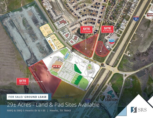

Property Detail
S Ih 35
30-002400-000302-0
MARTINEZ ACRES 3.6106
Commercialacreage
MCLENNAN
R
Texas
B and X Area of moderate flood hazard, usually the area between the limits of the 100-year and 500-year floods.
3.61 AC
2024
Waco
2025
Other Market Areas
003710
Waco, TX
NEARBY LISTINGS FOR SALE OR LEASE
DEMOGRAPHICS near S Ih 35
1 mile
3 mile
5 mile
2025 Total Population
1,806
18,137
39,464
2030 Population
1,903
18,761
40,688
Pop Growth 2025-2030
+ 5.37%
+ 3.44%
+ 3.10%
Average Age
42
39
40
2025 Total Households
652
6,655
14,636
HH Growth 2025-2030
+ 5.37%
+ 3.41%
+ 3.11%
Median Household Inc
$125,227
$100,460
$93,368
Avg Household Size
2.80
2.70
2.60
2025 Avg HH Vehicles
2.00
2.00
2.00
Median Home Value
$352,713
$305,089
$311,380
Median Year Built
2003
1996
1996
Nearby Places
Map Layers
Map Styles
 Street
 Aerial
Layers
 Traffic
 Biking
Places
Listings with unknown addresses are not visible on the map
- Restaurants
- Banks
- Shops
- Fitness
- Groceries
PUBLIC TRANSPORTATION
AIRPORT
Waco Regional
Drive
Walk
Distance
Waco Regional
30 min
18.2 mi
Freight Ports
Port of Houston
Drive
Walk
Distance
Port of Houston
223 min
193.5 mi
Nearby Properties
Address
Land Use
TOTAL SIZE
Lot Size
Zoning
Address
Land Use
TOTAL SIZE
Lot Size
Zoning
279,135 SF
13 AC
Address
Land Use
TOTAL SIZE
Lot Size
Zoning
201,725 SF
29.47 AC
R
Address
Land Use
TOTAL SIZE
Lot Size
Zoning
99,179 SF
54.16 AC
R1
Address
Land Use
TOTAL SIZE
Lot Size
Zoning
119,071 SF
104.74 AC
R
Address
Land Use
TOTAL SIZE
Lot Size
Zoning
87,492 SF
29.99 AC
R1
Address
Land Use
TOTAL SIZE
Lot Size
Zoning
92,134 SF
18.34 AC
R
Address
Land Use
TOTAL SIZE
Lot Size
Zoning
162,693 SF
17.63 AC
Address
Land Use
TOTAL SIZE
Lot Size
Zoning
66,438 SF
17.07 AC
R
Address
Land Use
TOTAL SIZE
Lot Size
Zoning
11,176 SF
9.54 AC
Address
Land Use
TOTAL SIZE
Lot Size
Zoning
28,286 SF
16.23 AC
R
Address
Land Use
TOTAL SIZE
Lot Size
Zoning
42,271 SF
18.65 AC
Address
Land Use
TOTAL SIZE
Lot Size
Zoning
69,528 SF
19.62 AC
R1
Address
Land Use
TOTAL SIZE
Lot Size
Zoning
146.03 AC
Address
Land Use
TOTAL SIZE
Lot Size
Zoning
98,992 SF
185.80 AC
R
Address
Land Use
TOTAL SIZE
Lot Size
Zoning
40,174 SF
2.18 AC
C
Address
Land Use
TOTAL SIZE
Lot Size
Zoning
293,825 SF
15.61 AC
Address
Land Use
TOTAL SIZE
Lot Size
Zoning
52,500 SF
4.79 AC
R
Address
Land Use
TOTAL SIZE
Lot Size
Zoning
18,320 SF
12.25 AC
Address
Land Use
TOTAL SIZE
Lot Size
Zoning
82,946 SF
12.57 AC
R1
Address
Land Use
TOTAL SIZE
Lot Size
Zoning
19,251 SF
6.23 AC
R1
Address
Land Use
TOTAL SIZE
Lot Size
Zoning
25,779 SF
3.10 AC
C
Address
Land Use
TOTAL SIZE
Lot Size
Zoning
26,150 SF
5.44 AC
Address
Land Use
TOTAL SIZE
Lot Size
Zoning
4,839 SF
3.94 AC
Address
Land Use
TOTAL SIZE
Lot Size
Zoning
47,572 SF
5.72 AC
Address
Land Use
TOTAL SIZE
Lot Size
Zoning
18,900 SF
12.49 AC
Address
Land Use
TOTAL SIZE
Lot Size
Zoning
6,844 SF
1.83 AC
Address
Land Use
TOTAL SIZE
Lot Size
Zoning
34,877 SF
7.05 AC
C
Address
Land Use
TOTAL SIZE
Lot Size
Zoning
118,947 SF
10 AC
Address
Land Use
TOTAL SIZE
Lot Size
Zoning
41,030 SF
1.97 AC
C
Address
Land Use
TOTAL SIZE
Lot Size
Zoning
400 SF
4.62 AC
R1
The World's #1 Commercial Real Estate Marketplace
Connect with us
© 2026 CoStar Group
The information above has been obtained from sources believed reliable. While we do not doubt its accuracy we have not verified it and make no guarantee, warranty or representation about it. It is your responsibility to independently confirm its accuracy and completeness. Any projections, opinions, assumptions, or estimates used are for example only and do not represent the current or future performance of the property. The value of this transaction to you depends on tax and other factors which should be evaluated by your tax, financial, and legal advisors. You and your advisors should conduct a careful, independent investigation of the property to determine to your satisfaction the suitability of the property for your needs.