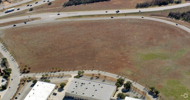
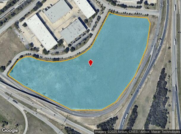
Property Record
S Ih 35, San Antonio, TX 78219
NEARBY LISTINGS FOR SALE OR LEASE
Property Detail
S Ih 35
San Antonio-New Braunfels, TX
Interstate Business Park Ut-4
17501-003-0010
NCB 17501 BLK 3 LOT 1 EXC NE IRR 81.07FT (INTERSTATE BUSINESS PARK UT-4) 2020-RMS PER SPLIT PER DEED 20190237724 EXE 09-27-19////2009-NEW ACCT PER PLAT 9584/0057-0061 FILED 3-14-08
Vacantlandnec
Bexar
X
Texas
48029C0408H
74
2024
21.60 AC
2025
Northeast
131504
San Antonio
DEMOGRAPHICS near S Ih 35
1 Mile
3 Mile
5 Mile
2024 Total Population
6,751
66,852
236,677
2029 Population
7,225
71,422
253,927
Pop Growth 2024-2029
+ 7.02%
+ 6.84%
+ 7.29%
Average Age
33
35
37
2024 Total Households
1,893
22,417
87,051
HH Growth 2024-2029
+ 6.87%
+ 6.90%
+ 7.50%
Median Household Inc
$51,352
$45,965
$53,073
Avg Household Size
3.00
2.80
2.60
2024 Avg HH Vehicles
2.00
2.00
2.00
Median Home Value
$139,743
$153,150
$190,783
Median Year Built
1978
1978
1977
Nearby Places
Map Layers
Map Styles
 Street
 Aerial
- Restaurants
- Banks
- Shops
- Fitness
- Groceries
PUBLIC TRANSPORTATION
COMMUTER RAIL
San Antonio Amtrak Station (Sunset Limited - Amtrak, Texas Eagle - Amtrak)
DRIVE
WALK
Distance
San Antonio Amtrak Station (Sunset Limited - Amtrak, Texas Eagle - Amtrak)
10 min
6.2 mi
AIRPORT
San Antonio International
DRIVE
WALK
Distance
San Antonio International
16 min
11.3 mi
Freight Ports
Calhoun Port
DRIVE
WALK
Distance
Calhoun Port
174 min
143.9 mi
SALE & LEASE HISTORY
LISTING DATE
SALE/LEASE

Sep 25, 2016
For Lease
Nearby Properties
Address
Land Use
TOTAL SIZE
Lot Size
Zoning
Address
Land Use
TOTAL SIZE
Lot Size
Zoning
2,544.56 AC
Address
Land Use
TOTAL SIZE
Lot Size
Zoning
1,649,488 SF
70 AC
Address
Land Use
TOTAL SIZE
Lot Size
Zoning
397,806 SF
15.08 AC
Address
Land Use
TOTAL SIZE
Lot Size
Zoning
359,459 SF
15.81 AC
Address
Land Use
TOTAL SIZE
Lot Size
Zoning
71,253 SF
25.52 AC
Address
Land Use
TOTAL SIZE
Lot Size
Zoning
Address
Land Use
TOTAL SIZE
Lot Size
Zoning
35.76 AC
Address
Land Use
TOTAL SIZE
Lot Size
Zoning
139,410 SF
35.75 AC
Address
Land Use
TOTAL SIZE
Lot Size
Zoning
598,070 SF
46.05 AC
Address
Land Use
TOTAL SIZE
Lot Size
Zoning
387,440 SF
27.71 AC
Address
Land Use
TOTAL SIZE
Lot Size
Zoning
273,516 SF
17.50 AC
Address
Land Use
TOTAL SIZE
Lot Size
Zoning
132.44 AC
Address
Land Use
TOTAL SIZE
Lot Size
Zoning
110,252 SF
20.04 AC
Address
Land Use
TOTAL SIZE
Lot Size
Zoning
300,987 SF
29.07 AC
Address
Land Use
TOTAL SIZE
Lot Size
Zoning
33.77 AC
Address
Land Use
TOTAL SIZE
Lot Size
Zoning
208,494 SF
9.63 AC
Address
Land Use
TOTAL SIZE
Lot Size
Zoning
300,555 SF
29.35 AC
Address
Land Use
TOTAL SIZE
Lot Size
Zoning
280,365 SF
17.72 AC
Address
Land Use
TOTAL SIZE
Lot Size
Zoning
437,807 SF
24.55 AC
Address
Land Use
TOTAL SIZE
Lot Size
Zoning
391,863 SF
24.43 AC
Address
Land Use
TOTAL SIZE
Lot Size
Zoning
306,000 SF
20.23 AC
Address
Land Use
TOTAL SIZE
Lot Size
Zoning
15.42 AC
Address
Land Use
TOTAL SIZE
Lot Size
Zoning
25,164 SF
13.31 AC
Address
Land Use
TOTAL SIZE
Lot Size
Zoning
251,680 SF
15.52 AC
Address
Land Use
TOTAL SIZE
Lot Size
Zoning
101,517 SF
13.04 AC
Address
Land Use
TOTAL SIZE
Lot Size
Zoning
224,840 SF
17.27 AC
Address
Land Use
TOTAL SIZE
Lot Size
Zoning
199,280 SF
11.50 AC
Address
Land Use
TOTAL SIZE
Lot Size
Zoning
362,280 SF
17.84 AC
Address
Land Use
TOTAL SIZE
Lot Size
Zoning
467,359 SF
34.88 AC
Address
Land Use
TOTAL SIZE
Lot Size
Zoning
68,055 SF
18.06 AC
The World's #1 Commercial Real Estate Marketplace
Connect with us
© 2025 CoStar Group
The information above has been obtained from sources believed reliable. While we do not doubt its accuracy we have not verified it and make no guarantee, warranty or representation about it. It is your responsibility to independently confirm its accuracy and completeness. Any projections, opinions, assumptions, or estimates used are for example only and do not represent the current or future performance of the property. The value of this transaction to you depends on tax and other factors which should be evaluated by your tax, financial, and legal advisors. You and your advisors should conduct a careful, independent investigation of the property to determine to your satisfaction the suitability of the property for your needs.