Property Record
S Interstate 35, Waxahachie, TX 75165


Property Detail
S Interstate 35
183319
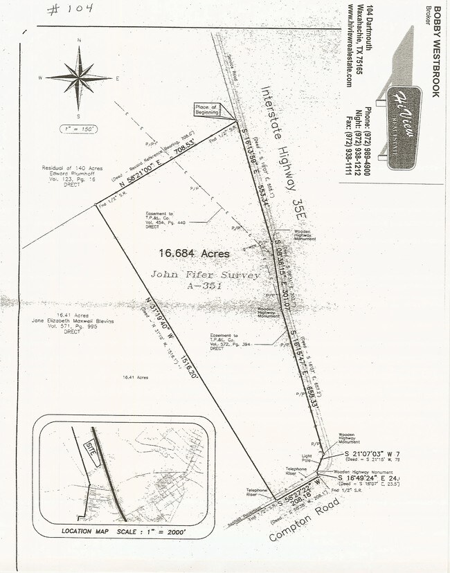
351 J FIFER 14.0983 ACRES
Agriculturalland
ELLIS
A Areas with a 1% annual chance of flooding and a 26% chance of flooding over the life of a 30-year mortgage.
Texas
2024
14.10 AC
2025
Ellis County
060300
Dallas/Ft Worth
1,512 SF
Dallas-Fort Worth-Arlington, TX
NEARBY LISTINGS FOR SALE OR LEASE
DEMOGRAPHICS near S Interstate 35
1 mile
3 mile
5 mile
2025 Total Population
3,392
28,426
55,807
2030 Population
3,905
32,966
65,463
Pop Growth 2025-2030
+ 15.12%
+ 15.97%
+ 17.30%
Average Age
35
37
37
2025 Total Households
1,149
10,381
19,524
HH Growth 2025-2030
+ 15.32%
+ 16.07%
+ 17.31%
Median Household Inc
$73,534
$67,785
$80,425
Avg Household Size
2.80
2.60
2.70
2025 Avg HH Vehicles
2.00
2.00
2.00
Median Home Value
$324,643
$327,213
$358,876
Median Year Built
1984
1988
2001
Nearby Places
Map Layers
Map Styles
 Street
 Aerial
Layers
 Traffic
 Biking
Places
Listings with unknown addresses are not visible on the map
- Restaurants
- Banks
- Shops
- Fitness
- Groceries
Nearby Properties
Address
Land Use
TOTAL SIZE
Lot Size
Zoning
Address
Land Use
TOTAL SIZE
Lot Size
Zoning
630,460 SF
71.82 AC
Address
Land Use
TOTAL SIZE
Lot Size
Zoning
643,064 SF
42.15 AC
Address
Land Use
TOTAL SIZE
Lot Size
Zoning
290,107 SF
9 AC
Address
Land Use
TOTAL SIZE
Lot Size
Zoning
259,166 SF
11.07 AC
Address
Land Use
TOTAL SIZE
Lot Size
Zoning
258,147 SF
12.40 AC
Address
Land Use
TOTAL SIZE
Lot Size
Zoning
198,180 SF
11.48 AC
Address
Land Use
TOTAL SIZE
Lot Size
Zoning
134,530 SF
12.11 AC
Address
Land Use
TOTAL SIZE
Lot Size
Zoning
114,400 SF
3.52 AC
Address
Land Use
TOTAL SIZE
Lot Size
Zoning
118,782 SF
5.11 AC
Address
Land Use
TOTAL SIZE
Lot Size
Zoning
79,800 SF
0.92 AC
Address
Land Use
TOTAL SIZE
Lot Size
Zoning
886,858 SF
8.60 AC
Address
Land Use
TOTAL SIZE
Lot Size
Zoning
109,978 SF
28.14 AC
Address
Land Use
TOTAL SIZE
Lot Size
Zoning
278,000 SF
22.82 AC
Address
Land Use
TOTAL SIZE
Lot Size
Zoning
115,544 SF
6.70 AC
Address
Land Use
TOTAL SIZE
Lot Size
Zoning
120,587 SF
23.95 AC
Address
Land Use
TOTAL SIZE
Lot Size
Zoning
84,940 SF
5.27 AC
Address
Land Use
TOTAL SIZE
Lot Size
Zoning
103,490 SF
10 AC
Address
Land Use
TOTAL SIZE
Lot Size
Zoning
109,423 SF
7.04 AC
Address
Land Use
TOTAL SIZE
Lot Size
Zoning
205,027 SF
22.65 AC
Address
Land Use
TOTAL SIZE
Lot Size
Zoning
211,030 SF
10.35 AC
Address
Land Use
TOTAL SIZE
Lot Size
Zoning
97,437 SF
10.85 AC
Address
Land Use
TOTAL SIZE
Lot Size
Zoning
57,343 SF
14.67 AC
Address
Land Use
TOTAL SIZE
Lot Size
Zoning
181,129 SF
15.68 AC
Address
Land Use
TOTAL SIZE
Lot Size
Zoning
43,330 SF
5 AC
Address
Land Use
TOTAL SIZE
Lot Size
Zoning
86,543 SF
147.93 AC
Address
Land Use
TOTAL SIZE
Lot Size
Zoning
4,784 SF
47.29 AC
Address
Land Use
TOTAL SIZE
Lot Size
Zoning
86,360 SF
4.26 AC
Address
Land Use
TOTAL SIZE
Lot Size
Zoning
85,264 SF
5.90 AC
Address
Land Use
TOTAL SIZE
Lot Size
Zoning
38,692 SF
5.72 AC
Address
Land Use
TOTAL SIZE
Lot Size
Zoning
78,325 SF
6.85 AC
The World's #1 Commercial Real Estate Marketplace
Connect with us
© 2026 CoStar Group
The information above has been obtained from sources believed reliable. While we do not doubt its accuracy we have not verified it and make no guarantee, warranty or representation about it. It is your responsibility to independently confirm its accuracy and completeness. Any projections, opinions, assumptions, or estimates used are for example only and do not represent the current or future performance of the property. The value of this transaction to you depends on tax and other factors which should be evaluated by your tax, financial, and legal advisors. You and your advisors should conduct a careful, independent investigation of the property to determine to your satisfaction the suitability of the property for your needs.