Property Record
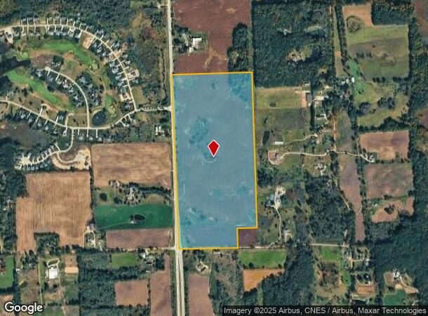
S Lapeer Rd, Oxford, MI 48371
This Property Is For Sale
NEARBY LISTINGS FOR SALE OR LEASE
-
-
View all Oxford listings for sale on LoopNet.com
Property Detail
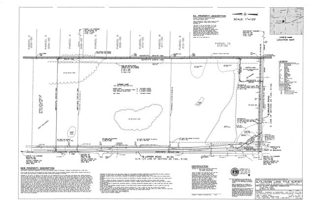
S Lapeer Rd
015-029-002-10
SEC 29, T6N R1OE. BEG IN M-24 AT S 1/4 COR SEC 24; TH ALG N/S 1/4 LN IN M-24 N 00-09-06 W 2619.23 FT TO SEC CEN; TH EXT ALG
Residentialacreage
Lapeer
X
Michigan
26087C0400E
87.10 AC
2024
St Clair & Lapeer Counties
2025
Detroit
121400
Detroit-Warren-Dearborn, MI
DEMOGRAPHICS near S Lapeer Rd
1 Mile
3 Mile
5 Mile
2024 Total Population
524
4,308
12,431
2029 Population
533
4,324
12,457
Pop Growth 2024-2029
+ 1.72%
+ 0.37%
+ 0.21%
Average Age
44
44
43
2024 Total Households
195
1,601
4,636
HH Growth 2024-2029
+ 2.05%
+ 0.44%
+ 0.22%
Median Household Inc
$100,391
$103,563
$99,235
Avg Household Size
2.70
2.70
2.60
2024 Avg HH Vehicles
3.00
3.00
2.00
Median Home Value
$359,482
$320,000
$329,336
Median Year Built
1986
1984
1988
Nearby Places
Map Layers
Map Styles
 Street
 Aerial
- Restaurants
- Banks
- Shops
- Fitness
- Groceries
PUBLIC TRANSPORTATION
AIRPORT
Bishop International
DRIVE
WALK
Distance
Bishop International
51 min
36.0 mi
Freight Ports
Port of Toledo
DRIVE
WALK
Distance
Port of Toledo
134 min
106.8 mi
Nearby Properties
Address
Land Use
TOTAL SIZE
Lot Size
Zoning
Address
Land Use
TOTAL SIZE
Lot Size
Zoning
147,978 SF
6.87 AC
INDUSTRIAL
Address
Land Use
TOTAL SIZE
Lot Size
Zoning
70,420 SF
4.49 AC
II
Address
Land Use
TOTAL SIZE
Lot Size
Zoning
51,898 SF
3.56 AC
II
Address
Land Use
TOTAL SIZE
Lot Size
Zoning
60,600 SF
14.31 AC
II
Address
Land Use
TOTAL SIZE
Lot Size
Zoning
49,731 SF
5.75 AC
II
Address
Land Use
TOTAL SIZE
Lot Size
Zoning
68,162 SF
4.97 AC
II
Address
Land Use
TOTAL SIZE
Lot Size
Zoning
45,554 SF
2.74 AC
II
Address
Land Use
TOTAL SIZE
Lot Size
Zoning
46,838 SF
4.56 AC
II
Address
Land Use
TOTAL SIZE
Lot Size
Zoning
220.81 AC
A-2
Address
Land Use
TOTAL SIZE
Lot Size
Zoning
22,767 SF
4.60 AC
II
Address
Land Use
TOTAL SIZE
Lot Size
Zoning
27,912 SF
9.11 AC
II
Address
Land Use
TOTAL SIZE
Lot Size
Zoning
23,820 SF
9.74 AC
II
Address
Land Use
TOTAL SIZE
Lot Size
Zoning
14,792 SF
6.28 AC
II
Address
Land Use
TOTAL SIZE
Lot Size
Zoning
25,822 SF
4.55 AC
II
Address
Land Use
TOTAL SIZE
Lot Size
Zoning
7 AC
MM
Address
Land Use
TOTAL SIZE
Lot Size
Zoning
17,680 SF
2.87 AC
II
Address
Land Use
TOTAL SIZE
Lot Size
Zoning
11,180 SF
2.05 AC
B-2
Address
Land Use
TOTAL SIZE
Lot Size
Zoning
5,305 SF
2.27 AC
B-2
Address
Land Use
TOTAL SIZE
Lot Size
Zoning
183.40 AC
A-2
Address
Land Use
TOTAL SIZE
Lot Size
Zoning
26,527 SF
3.70 AC
II
Address
Land Use
TOTAL SIZE
Lot Size
Zoning
175 AC
AR
Address
Land Use
TOTAL SIZE
Lot Size
Zoning
31,322 SF
2.29 AC
II
Address
Land Use
TOTAL SIZE
Lot Size
Zoning
102.31 AC
A-2
Address
Land Use
TOTAL SIZE
Lot Size
Zoning
177.92 AC
R-1
Address
Land Use
TOTAL SIZE
Lot Size
Zoning
995 SF
156.21 AC
A-1
Address
Land Use
TOTAL SIZE
Lot Size
Zoning
19,740 SF
3.01 AC
B-2
Address
Land Use
TOTAL SIZE
Lot Size
Zoning
2,755 SF
93.56 AC
AR
Address
Land Use
TOTAL SIZE
Lot Size
Zoning
3,168 SF
1.43 AC
B-2
The World's #1 Commercial Real Estate Marketplace
Connect with us
© 2026 CoStar Group
The information above has been obtained from sources believed reliable. While we do not doubt its accuracy we have not verified it and make no guarantee, warranty or representation about it. It is your responsibility to independently confirm its accuracy and completeness. Any projections, opinions, assumptions, or estimates used are for example only and do not represent the current or future performance of the property. The value of this transaction to you depends on tax and other factors which should be evaluated by your tax, financial, and legal advisors. You and your advisors should conduct a careful, independent investigation of the property to determine to your satisfaction the suitability of the property for your needs.