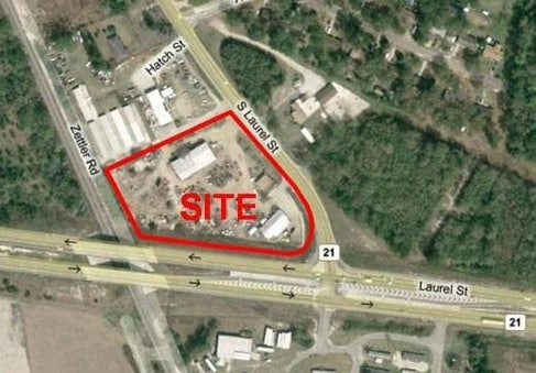
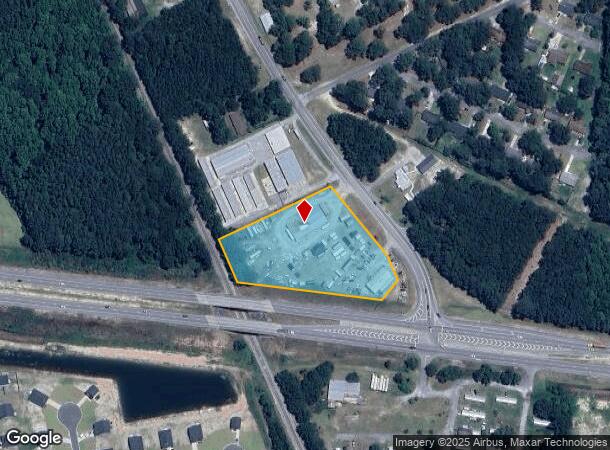
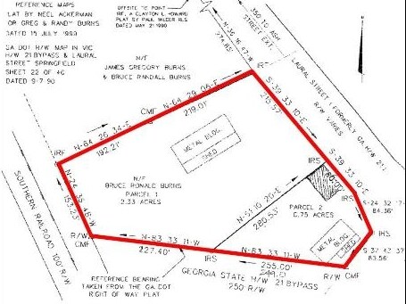
Property Record
S Laurel St, Springfield, GA 31329
NEARBY LISTINGS FOR SALE OR LEASE
Property Detail
S Laurel St
S1110-00000-003-000
Springfieldcom
Commercialnec
3.08 AC TRACTOR CO
X
Effingham
13103C0164E
Georgia
2024
3.08 AC
2025
Effingham County
030206
Savannah
3,200 SF
Savannah, GA
DEMOGRAPHICS near S Laurel St
1 Mile
3 Mile
5 Mile
2024 Total Population
2,270
8,688
15,021
2029 Population
2,652
10,122
17,533
Pop Growth 2024-2029
+ 16.83%
+ 16.51%
+ 16.72%
Average Age
38
37
37
2024 Total Households
759
2,965
5,186
HH Growth 2024-2029
+ 16.86%
+ 16.49%
+ 16.72%
Median Household Inc
$65,857
$66,145
$71,934
Avg Household Size
2.80
2.80
2.80
2024 Avg HH Vehicles
2.00
2.00
2.00
Median Home Value
$227,649
$222,820
$231,634
Median Year Built
1999
2000
2001
Nearby Places
- Restaurants
- Banks
- Shops
- Fitness
- Groceries
PUBLIC TRANSPORTATION
AIRPORT
Savannah/Hilton Head International
DRIVE
WALK
Distance
Savannah/Hilton Head International
33 min
22.5 mi
Freight Ports
Georgia Ports - Savannah
DRIVE
WALK
Distance
Georgia Ports - Savannah
28 min
20.9 mi
Nearby Properties
Address
Land Use
TOTAL SIZE
Lot Size
Zoning
Address
Land Use
TOTAL SIZE
Lot Size
Zoning
6,914 SF
11.15 AC
B-1
Address
Land Use
TOTAL SIZE
Lot Size
Zoning
52,779 SF
0.82 AC
B-2
Address
Land Use
TOTAL SIZE
Lot Size
Zoning
42,403 SF
30 AC
AR-1
Address
Land Use
TOTAL SIZE
Lot Size
Zoning
10,200 SF
6.92 AC
B-1
Address
Land Use
TOTAL SIZE
Lot Size
Zoning
102,010 SF
5.94 AC
I-1
Address
Land Use
TOTAL SIZE
Lot Size
Zoning
97,800 SF
6.72 AC
I-1
Address
Land Use
TOTAL SIZE
Lot Size
Zoning
21,445 SF
1.60 AC
B-2
Address
Land Use
TOTAL SIZE
Lot Size
Zoning
14,472 SF
2.27 AC
B-1
Address
Land Use
TOTAL SIZE
Lot Size
Zoning
30,400 SF
3.17 AC
I-1
Address
Land Use
TOTAL SIZE
Lot Size
Zoning
5,400 SF
11.29 AC
I-1
Address
Land Use
TOTAL SIZE
Lot Size
Zoning
55,200 SF
9.04 AC
I-1
Address
Land Use
TOTAL SIZE
Lot Size
Zoning
15,088 SF
11.31 AC
B-3
Address
Land Use
TOTAL SIZE
Lot Size
Zoning
10,872 SF
5 AC
I-1
Address
Land Use
TOTAL SIZE
Lot Size
Zoning
53,184 SF
5 AC
I-1
Address
Land Use
TOTAL SIZE
Lot Size
Zoning
45,627 SF
5 AC
I-1
Address
Land Use
TOTAL SIZE
Lot Size
Zoning
5,066 SF
2.67 AC
B-1
Address
Land Use
TOTAL SIZE
Lot Size
Zoning
10,857 SF
1.45 AC
B-1
Address
Land Use
TOTAL SIZE
Lot Size
Zoning
20,776 SF
0.92 AC
R-1
Address
Land Use
TOTAL SIZE
Lot Size
Zoning
11,036 SF
6.15 AC
R-1
Address
Land Use
TOTAL SIZE
Lot Size
Zoning
17,855 SF
1.16 AC
B-2
Address
Land Use
TOTAL SIZE
Lot Size
Zoning
30,000 SF
3.79 AC
I-1
Address
Land Use
TOTAL SIZE
Lot Size
Zoning
4,902 SF
1.99 AC
B-1
Address
Land Use
TOTAL SIZE
Lot Size
Zoning
13,036 SF
3.33 AC
B-1
Address
Land Use
TOTAL SIZE
Lot Size
Zoning
5,949 SF
3.26 AC
AR-1
Address
Land Use
TOTAL SIZE
Lot Size
Zoning
27,762 SF
1.45 AC
R-1
Address
Land Use
TOTAL SIZE
Lot Size
Zoning
10,000 SF
0.57 AC
B-2
Address
Land Use
TOTAL SIZE
Lot Size
Zoning
10,155 SF
1.39 AC
B-1
Address
Land Use
TOTAL SIZE
Lot Size
Zoning
22,516 SF
0.61 AC
B-2
Address
Land Use
TOTAL SIZE
Lot Size
Zoning
6,916 SF
0.92 AC
B-2
Address
Land Use
TOTAL SIZE
Lot Size
Zoning
2,108 SF
2.29 AC
B-1
The World's #1 Commercial Real Estate Marketplace
Connect with us
© 2025 CoStar Group
The information above has been obtained from sources believed reliable. While we do not doubt its accuracy we have not verified it and make no guarantee, warranty or representation about it. It is your responsibility to independently confirm its accuracy and completeness. Any projections, opinions, assumptions, or estimates used are for example only and do not represent the current or future performance of the property. The value of this transaction to you depends on tax and other factors which should be evaluated by your tax, financial, and legal advisors. You and your advisors should conduct a careful, independent investigation of the property to determine to your satisfaction the suitability of the property for your needs.