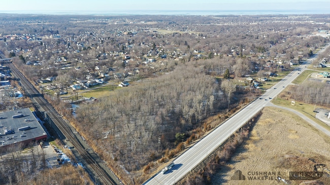
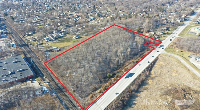
Property Record
S Leavitt Rd, Amherst, OH 44001
NEARBY LISTINGS FOR SALE OR LEASE
-
-
-
No Photo
-
View all Amherst listings for sale on LoopNet.com
Property Detail
S Leavitt Rd
Cleveland-Elyria, OH
Northgate Sub
05-00-037-110-022
NORTHGATE SUB 56.69 X 157 S/L 11
Residentialacreage
Lorain
X
Ohio
39093C0114D
11
2024
0.24 AC
2024
Lorain County
050301
Cleveland
DEMOGRAPHICS near S Leavitt Rd
1 Mile
3 Mile
5 Mile
2024 Total Population
5,840
34,990
86,352
2029 Population
6,013
36,401
90,114
Pop Growth 2024-2029
+ 2.96%
+ 4.03%
+ 4.36%
Average Age
44
43
41
2024 Total Households
2,419
14,428
35,883
HH Growth 2024-2029
+ 2.89%
+ 3.99%
+ 4.33%
Median Household Inc
$83,842
$76,590
$50,540
Avg Household Size
2.40
2.40
2.30
2024 Avg HH Vehicles
2.00
2.00
2.00
Median Home Value
$171,372
$185,583
$150,535
Median Year Built
1963
1975
1967
Nearby Places
Map Layers
Map Styles
 Street
 Aerial
- Restaurants
- Banks
- Shops
- Fitness
- Groceries
PUBLIC TRANSPORTATION
AIRPORT
Cleveland-Hopkins International
DRIVE
WALK
Distance
Cleveland-Hopkins International
36 min
23.8 mi
Freight Ports
Port of Toledo
DRIVE
WALK
Distance
Port of Toledo
106 min
85.7 mi
SALE & LEASE HISTORY
LISTING DATE
SALE/LEASE

Sep 24, 2016
For Sale
Feb 13, 2023
For Sale
Nearby Properties
Address
Land Use
TOTAL SIZE
Lot Size
Zoning
Address
Land Use
TOTAL SIZE
Lot Size
Zoning
118,624 SF
19.80 AC
Address
Land Use
TOTAL SIZE
Lot Size
Zoning
111,373 SF
9.35 AC
Address
Land Use
TOTAL SIZE
Lot Size
Zoning
160,080 SF
14.89 AC
Address
Land Use
TOTAL SIZE
Lot Size
Zoning
43,576 SF
12.37 AC
Address
Land Use
TOTAL SIZE
Lot Size
Zoning
35,502 SF
23.29 AC
Address
Land Use
TOTAL SIZE
Lot Size
Zoning
36.66 AC
Address
Land Use
TOTAL SIZE
Lot Size
Zoning
178,140 SF
15.67 AC
Address
Land Use
TOTAL SIZE
Lot Size
Zoning
30,744 SF
5.10 AC
Address
Land Use
TOTAL SIZE
Lot Size
Zoning
31,871 SF
6.90 AC
Address
Land Use
TOTAL SIZE
Lot Size
Zoning
9,880 SF
3.90 AC
Address
Land Use
TOTAL SIZE
Lot Size
Zoning
22,894 SF
9.60 AC
Address
Land Use
TOTAL SIZE
Lot Size
Zoning
54,831 SF
3.93 AC
Address
Land Use
TOTAL SIZE
Lot Size
Zoning
66,196 SF
7.05 AC
Address
Land Use
TOTAL SIZE
Lot Size
Zoning
80,852 SF
9.41 AC
Address
Land Use
TOTAL SIZE
Lot Size
Zoning
57,730 SF
7.35 AC
Address
Land Use
TOTAL SIZE
Lot Size
Zoning
67,408 SF
14.83 AC
Address
Land Use
TOTAL SIZE
Lot Size
Zoning
64,442 SF
7.67 AC
Address
Land Use
TOTAL SIZE
Lot Size
Zoning
138,499 SF
10.07 AC
Address
Land Use
TOTAL SIZE
Lot Size
Zoning
139,368 SF
13.48 AC
Address
Land Use
TOTAL SIZE
Lot Size
Zoning
23,068 SF
2.94 AC
Address
Land Use
TOTAL SIZE
Lot Size
Zoning
17,787 SF
3.67 AC
Address
Land Use
TOTAL SIZE
Lot Size
Zoning
127,146 SF
9.54 AC
Address
Land Use
TOTAL SIZE
Lot Size
Zoning
19,947 SF
8.14 AC
Address
Land Use
TOTAL SIZE
Lot Size
Zoning
90,188 SF
8.31 AC
Address
Land Use
TOTAL SIZE
Lot Size
Zoning
54,211 SF
3.57 AC
Address
Land Use
TOTAL SIZE
Lot Size
Zoning
19,512 SF
3.64 AC
Address
Land Use
TOTAL SIZE
Lot Size
Zoning
22,737 SF
8.58 AC
Address
Land Use
TOTAL SIZE
Lot Size
Zoning
27,756 SF
2.61 AC
Address
Land Use
TOTAL SIZE
Lot Size
Zoning
33,368 SF
7.82 AC
Address
Land Use
TOTAL SIZE
Lot Size
Zoning
28,524 SF
5.90 AC
The World's #1 Commercial Real Estate Marketplace
Connect with us
© 2025 CoStar Group
The information above has been obtained from sources believed reliable. While we do not doubt its accuracy we have not verified it and make no guarantee, warranty or representation about it. It is your responsibility to independently confirm its accuracy and completeness. Any projections, opinions, assumptions, or estimates used are for example only and do not represent the current or future performance of the property. The value of this transaction to you depends on tax and other factors which should be evaluated by your tax, financial, and legal advisors. You and your advisors should conduct a careful, independent investigation of the property to determine to your satisfaction the suitability of the property for your needs.