Property Record
S Lehmberg Rd, Columbus, MS 39702
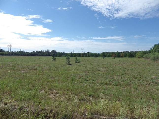

Property Detail
S Lehmberg Rd
Columbus, MS
PT NW4 S LEHMBERG RD
68W00-00-02500
LOWNDES
Timberlandforesttreesagricultural
Mississippi
AE The base floodplain where base flood elevations are provided. AE Zones are now used on new format FIRMs instead of A1-A30 Zones.
94.80 AC
2025
Vicksburg/Central Area
2025
Other Market Areas
000406
NEARBY LISTINGS FOR SALE OR LEASE
-
-
View all Columbus listings for sale on LoopNet.com
DEMOGRAPHICS near S Lehmberg Rd
1 mile
3 mile
5 mile
2025 Total Population
1,430
14,383
30,926
2030 Population
1,393
13,880
30,337
Pop Growth 2025-2030
(2.59%)
(3.50%)
(1.90%)
Average Age
33
39
40
2025 Total Households
535
5,436
12,401
HH Growth 2025-2030
(2.62%)
(3.62%)
(1.87%)
Median Household Inc
$19,172
$42,386
$42,035
Avg Household Size
2.70
2.40
2.30
2025 Avg HH Vehicles
1.00
2.00
2.00
Median Home Value
$138,095
$157,536
$151,370
Median Year Built
1991
1980
1977
Nearby Places
Map Layers
Map Styles
 Street
 Aerial
Layers
 Traffic
 Biking
Places
Listings with unknown addresses are not visible on the map
- Restaurants
- Banks
- Shops
- Fitness
- Groceries
PUBLIC TRANSPORTATION
AIRPORT
Golden Triangle Regional
Drive
Walk
Distance
Golden Triangle Regional
32 min
18.5 mi
Freight Ports
Port of Mobile
Drive
Walk
Distance
Port of Mobile
270 min
228.0 mi
SALE & LEASE HISTORY
LISTING DATE
SALE/LEASE

Oct 26, 2016
For Sale
Nearby Properties
Address
Land Use
TOTAL SIZE
Lot Size
Zoning
Address
Land Use
TOTAL SIZE
Lot Size
Zoning
13,500 SF
12.20 AC
Address
Land Use
TOTAL SIZE
Lot Size
Zoning
2,044 SF
12.90 AC
Address
Land Use
TOTAL SIZE
Lot Size
Zoning
5,280 SF
9.70 AC
Address
Land Use
TOTAL SIZE
Lot Size
Zoning
2,703 SF
3 AC
Address
Land Use
TOTAL SIZE
Lot Size
Zoning
1,976 SF
15.90 AC
Address
Land Use
TOTAL SIZE
Lot Size
Zoning
2,778 SF
11.80 AC
Address
Land Use
TOTAL SIZE
Lot Size
Zoning
136.40 AC
Address
Land Use
TOTAL SIZE
Lot Size
Zoning
2,503 SF
13.80 AC
Address
Land Use
TOTAL SIZE
Lot Size
Zoning
12,092 SF
1.70 AC
Address
Land Use
TOTAL SIZE
Lot Size
Zoning
14,000 SF
5 AC
Address
Land Use
TOTAL SIZE
Lot Size
Zoning
24,000 SF
18.30 AC
Address
Land Use
TOTAL SIZE
Lot Size
Zoning
2,856 SF
28.60 AC
Address
Land Use
TOTAL SIZE
Lot Size
Zoning
45,816 SF
7.66 AC
Address
Land Use
TOTAL SIZE
Lot Size
Zoning
6,202 SF
6.50 AC
Address
Land Use
TOTAL SIZE
Lot Size
Zoning
Address
Land Use
TOTAL SIZE
Lot Size
Zoning
33,366 SF
0.03 AC
Address
Land Use
TOTAL SIZE
Lot Size
Zoning
3,120 SF
5 AC
Address
Land Use
TOTAL SIZE
Lot Size
Zoning
26,716 SF
6.75 AC
Address
Land Use
TOTAL SIZE
Lot Size
Zoning
13,200 SF
1.65 AC
Address
Land Use
TOTAL SIZE
Lot Size
Zoning
5,608 SF
5.40 AC
Address
Land Use
TOTAL SIZE
Lot Size
Zoning
5,000 SF
6.50 AC
Address
Land Use
TOTAL SIZE
Lot Size
Zoning
22,024 SF
5 AC
Address
Land Use
TOTAL SIZE
Lot Size
Zoning
24,304 SF
7.80 AC
Address
Land Use
TOTAL SIZE
Lot Size
Zoning
5,338 SF
1.43 AC
Address
Land Use
TOTAL SIZE
Lot Size
Zoning
37.50 AC
Address
Land Use
TOTAL SIZE
Lot Size
Zoning
474,720 SF
72.10 AC
Address
Land Use
TOTAL SIZE
Lot Size
Zoning
6,214 SF
10 AC
Address
Land Use
TOTAL SIZE
Lot Size
Zoning
28,500 SF
3.70 AC
Address
Land Use
TOTAL SIZE
Lot Size
Zoning
110,215 SF
4.50 AC
Address
Land Use
TOTAL SIZE
Lot Size
Zoning
1,390 SF
6.40 AC
The World's #1 Commercial Real Estate Marketplace
Connect with us
© 2026 CoStar Group
The information above has been obtained from sources believed reliable. While we do not doubt its accuracy we have not verified it and make no guarantee, warranty or representation about it. It is your responsibility to independently confirm its accuracy and completeness. Any projections, opinions, assumptions, or estimates used are for example only and do not represent the current or future performance of the property. The value of this transaction to you depends on tax and other factors which should be evaluated by your tax, financial, and legal advisors. You and your advisors should conduct a careful, independent investigation of the property to determine to your satisfaction the suitability of the property for your needs.