Property Record
S Main St, Gaston, SC 29053
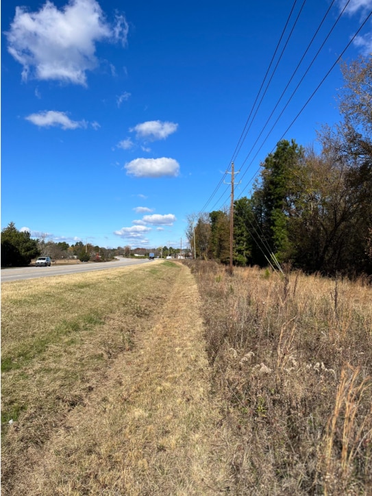
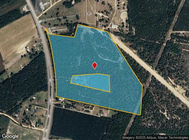
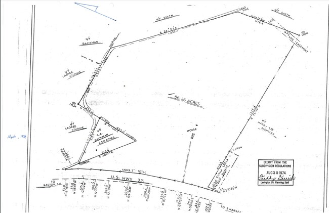
This Property Is For Sale
NEARBY LISTINGS FOR SALE OR LEASE
-
-
View all Gaston listings for sale on LoopNet.com
Property Detail
S Main St
011100-02-009
NONE 11100-2-15 HAS BEEN CBW 11100-2-9
Residentialacreage
Lexington
X
South Carolina
45063C0415J
53.73 AC
2025
Outlying Lexington County
2024
Columbia
020806
Columbia, SC
DEMOGRAPHICS near S Main St
1 Mile
3 Mile
5 Mile
2024 Total Population
483
7,654
19,708
2029 Population
535
8,482
21,719
Pop Growth 2024-2029
+ 10.77%
+ 10.82%
+ 10.20%
Average Age
39
39
39
2024 Total Households
182
2,819
7,307
HH Growth 2024-2029
+ 10.44%
+ 10.96%
+ 10.28%
Median Household Inc
$43,333
$41,387
$42,655
Avg Household Size
2.50
2.60
2.60
2024 Avg HH Vehicles
2.00
2.00
2.00
Median Home Value
$78,408
$79,035
$87,527
Median Year Built
1986
1991
1992
Nearby Places
- Restaurants
- Banks
- Shops
- Fitness
- Groceries
PUBLIC TRANSPORTATION
AIRPORT
Columbia Metro
DRIVE
WALK
Distance
Columbia Metro
27 min
16.5 mi
Freight Ports
North Charleston Terminal
DRIVE
WALK
Distance
North Charleston Terminal
113 min
96.5 mi
Nearby Properties
Address
Land Use
TOTAL SIZE
Lot Size
Zoning
Address
Land Use
TOTAL SIZE
Lot Size
Zoning
39,216 SF
271.81 AC
ID
Address
Land Use
TOTAL SIZE
Lot Size
Zoning
9,180 SF
10.66 AC
Address
Land Use
TOTAL SIZE
Lot Size
Zoning
64,200 SF
8.53 AC
LR
Address
Land Use
TOTAL SIZE
Lot Size
Zoning
21.80 AC
Address
Land Use
TOTAL SIZE
Lot Size
Zoning
7,150 SF
2.46 AC
Address
Land Use
TOTAL SIZE
Lot Size
Zoning
12,400 SF
1.62 AC
RD
Address
Land Use
TOTAL SIZE
Lot Size
Zoning
5,880 SF
1.02 AC
Address
Land Use
TOTAL SIZE
Lot Size
Zoning
6,840 SF
0.82 AC
Address
Land Use
TOTAL SIZE
Lot Size
Zoning
18,358 SF
1.75 AC
RD
Address
Land Use
TOTAL SIZE
Lot Size
Zoning
3,360 SF
1.34 AC
RD
Address
Land Use
TOTAL SIZE
Lot Size
Zoning
2.50 AC
Address
Land Use
TOTAL SIZE
Lot Size
Zoning
23,387 SF
8.32 AC
ID
Address
Land Use
TOTAL SIZE
Lot Size
Zoning
145.70 AC
Address
Land Use
TOTAL SIZE
Lot Size
Zoning
5,828 SF
2.04 AC
Address
Land Use
TOTAL SIZE
Lot Size
Zoning
27.47 AC
ID
Address
Land Use
TOTAL SIZE
Lot Size
Zoning
3,153 SF
1 AC
Address
Land Use
TOTAL SIZE
Lot Size
Zoning
1,216 SF
7.47 AC
RD
Address
Land Use
TOTAL SIZE
Lot Size
Zoning
18,225 SF
2.37 AC
LR
Address
Land Use
TOTAL SIZE
Lot Size
Zoning
2,400 SF
12 AC
RD
Address
Land Use
TOTAL SIZE
Lot Size
Zoning
134.04 AC
LR
Address
Land Use
TOTAL SIZE
Lot Size
Zoning
1.64 AC
Address
Land Use
TOTAL SIZE
Lot Size
Zoning
5,000 SF
3.43 AC
Address
Land Use
TOTAL SIZE
Lot Size
Zoning
6,791 SF
0.85 AC
Address
Land Use
TOTAL SIZE
Lot Size
Zoning
3,140 SF
0.99 AC
Address
Land Use
TOTAL SIZE
Lot Size
Zoning
176 AC
LR
Address
Land Use
TOTAL SIZE
Lot Size
Zoning
3,612 SF
1.01 AC
RD
Address
Land Use
TOTAL SIZE
Lot Size
Zoning
3,468 SF
1.51 AC
LR
Address
Land Use
TOTAL SIZE
Lot Size
Zoning
40.45 AC
LR
Address
Land Use
TOTAL SIZE
Lot Size
Zoning
900 SF
1.30 AC
LR
Address
Land Use
TOTAL SIZE
Lot Size
Zoning
The World's #1 Commercial Real Estate Marketplace
Connect with us
© 2025 CoStar Group
The information above has been obtained from sources believed reliable. While we do not doubt its accuracy we have not verified it and make no guarantee, warranty or representation about it. It is your responsibility to independently confirm its accuracy and completeness. Any projections, opinions, assumptions, or estimates used are for example only and do not represent the current or future performance of the property. The value of this transaction to you depends on tax and other factors which should be evaluated by your tax, financial, and legal advisors. You and your advisors should conduct a careful, independent investigation of the property to determine to your satisfaction the suitability of the property for your needs.