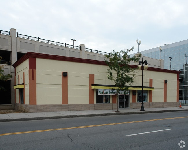
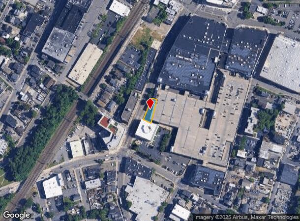
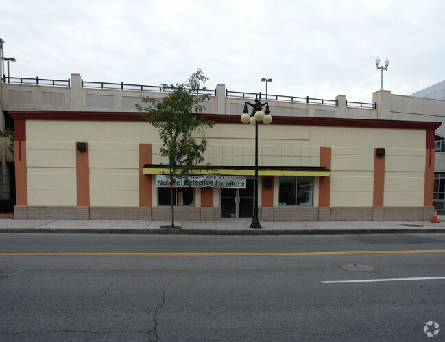
Property Record
S Main St, Port Chester, NY 10573
NEARBY LISTINGS FOR SALE OR LEASE
Property Detail
S Main St
4801-142-000-00038-002-0062-0000000
Westchester
Storesoffices
New York
AE
62.000
09001C0606G
0.13 AC
2025
East I-287 Corridor
2024
Westchester/So Connecticut
008200
New York-Jersey City-White Plains, NY-NJ
1,728 SF
DEMOGRAPHICS near S Main St
1 Mile
3 Mile
5 Mile
2024 Total Population
27,737
74,379
133,903
2029 Population
26,352
72,479
131,292
Pop Growth 2024-2029
(4.99%)
(2.55%)
(1.95%)
Average Age
39
41
41
2024 Total Households
9,428
26,470
47,442
HH Growth 2024-2029
(5.03%)
(2.48%)
(1.99%)
Median Household Inc
$87,337
$126,274
$141,456
Avg Household Size
2.80
2.70
2.70
2024 Avg HH Vehicles
1.00
2.00
2.00
Median Home Value
$573,401
$881,027
$926,668
Median Year Built
1955
1958
1958
Nearby Places
- Restaurants
- Banks
- Shops
- Fitness
- Groceries
PUBLIC TRANSPORTATION
COMMUTER RAIL
Port Chester Station (New Haven Line - Metro-North Commuter Railroad Company (Metro-North))
DRIVE
WALK
Distance
Port Chester Station (New Haven Line - Metro-North Commuter Railroad Company (Metro-North))
1 min
6 min
0.3 mi
Rye Station (New Haven Line - Metro-North Commuter Railroad Company (Metro-North))
DRIVE
WALK
Distance
Rye Station (New Haven Line - Metro-North Commuter Railroad Company (Metro-North))
3 min
1.6 mi
AIRPORT
Westchester County
DRIVE
WALK
Distance
Westchester County
13 min
6.6 mi
LaGuardia
DRIVE
WALK
Distance
LaGuardia
38 min
24.1 mi
John F Kennedy International
DRIVE
WALK
Distance
John F Kennedy International
45 min
31.7 mi
Freight Ports
NY - Red Hook Container Terminal
DRIVE
WALK
Distance
NY - Red Hook Container Terminal
53 min
34.6 mi
Nearby Properties
Address
Land Use
TOTAL SIZE
Lot Size
Zoning
Address
Land Use
TOTAL SIZE
Lot Size
Zoning
5COMMUND
Address
Land Use
TOTAL SIZE
Lot Size
Zoning
244,937 SF
4.20 AC
WB
Address
Land Use
TOTAL SIZE
Lot Size
Zoning
4,179 SF
3.32 AC
GBO
Address
Land Use
TOTAL SIZE
Lot Size
Zoning
175,339 SF
2.12 AC
CGB
Address
Land Use
TOTAL SIZE
Lot Size
Zoning
80,427 SF
18.06 AC
GBO
Address
Land Use
TOTAL SIZE
Lot Size
Zoning
277,172 SF
29.98 AC
CD COMM
Address
Land Use
TOTAL SIZE
Lot Size
Zoning
78,159 SF
4.17 AC
CGB
Address
Land Use
TOTAL SIZE
Lot Size
Zoning
192,254 SF
1.15 AC
GBO
Address
Land Use
TOTAL SIZE
Lot Size
Zoning
9,828 SF
22.01 AC
R-6
Address
Land Use
TOTAL SIZE
Lot Size
Zoning
93,514 SF
5 AC
CGB
Address
Land Use
TOTAL SIZE
Lot Size
Zoning
0.01 AC
5COMMUND
Address
Land Use
TOTAL SIZE
Lot Size
Zoning
32,256 SF
2.63 AC
CGB
Address
Land Use
TOTAL SIZE
Lot Size
Zoning
5COMMUND
Address
Land Use
TOTAL SIZE
Lot Size
Zoning
94,652 SF
2.91 AC
GB
Address
Land Use
TOTAL SIZE
Lot Size
Zoning
77,136 SF
3.76 AC
GB
Address
Land Use
TOTAL SIZE
Lot Size
Zoning
9,305 SF
35.53 AC
R-C7
Address
Land Use
TOTAL SIZE
Lot Size
Zoning
345,927 SF
4.32 AC
MUR WTRFR
Address
Land Use
TOTAL SIZE
Lot Size
Zoning
556,297 SF
25.31 AC
05 - COMME
Address
Land Use
TOTAL SIZE
Lot Size
Zoning
133,080 SF
1.01 AC
CGBR
Address
Land Use
TOTAL SIZE
Lot Size
Zoning
32,784 SF
2.70 AC
CGB
Address
Land Use
TOTAL SIZE
Lot Size
Zoning
811 SF
11.17 AC
RA-2
Address
Land Use
TOTAL SIZE
Lot Size
Zoning
60,317 SF
0.63 AC
CGBR
Address
Land Use
TOTAL SIZE
Lot Size
Zoning
117,252 SF
4.15 AC
GBO
Address
Land Use
TOTAL SIZE
Lot Size
Zoning
61,184 SF
2.27 AC
R-MF
Address
Land Use
TOTAL SIZE
Lot Size
Zoning
8.06 AC
CGB
Address
Land Use
TOTAL SIZE
Lot Size
Zoning
5COMMUND
Address
Land Use
TOTAL SIZE
Lot Size
Zoning
91,202 SF
22.09 AC
R-6
Address
Land Use
TOTAL SIZE
Lot Size
Zoning
68,678 SF
12 AC
R-6
Address
Land Use
TOTAL SIZE
Lot Size
Zoning
42,306 SF
20.35 AC
GB
Address
Land Use
TOTAL SIZE
Lot Size
Zoning
47,691 SF
1.02 AC
CGBR
The World's #1 Commercial Real Estate Marketplace
Connect with us
© 2025 CoStar Group
The information above has been obtained from sources believed reliable. While we do not doubt its accuracy we have not verified it and make no guarantee, warranty or representation about it. It is your responsibility to independently confirm its accuracy and completeness. Any projections, opinions, assumptions, or estimates used are for example only and do not represent the current or future performance of the property. The value of this transaction to you depends on tax and other factors which should be evaluated by your tax, financial, and legal advisors. You and your advisors should conduct a careful, independent investigation of the property to determine to your satisfaction the suitability of the property for your needs.