Property Record
S Maplewood Rd, Monticello, NY 12701
NEARBY LISTINGS FOR SALE OR LEASE
Property Detail
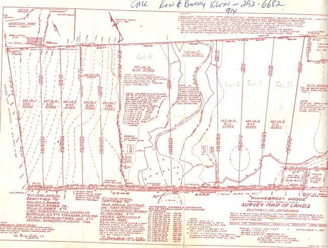
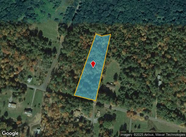
S Maplewood Rd
4689-027-0-0001-013-006
LOT 6
Residentialacreage
Sullivan
X
New York
36105C0465F
13.006
2025
2.51 AC
2024
Hudson Valley Area
951802
Other Market Areas
DEMOGRAPHICS near S Maplewood Rd
1 Mile
3 Mile
5 Mile
2024 Total Population
168
8,361
16,875
2029 Population
174
8,842
17,734
Pop Growth 2024-2029
+ 3.57%
+ 5.75%
+ 5.09%
Average Age
42
40
41
2024 Total Households
63
3,355
6,788
HH Growth 2024-2029
+ 4.76%
+ 5.99%
+ 5.35%
Median Household Inc
$60,750
$39,275
$48,391
Avg Household Size
2.40
2.30
2.30
2024 Avg HH Vehicles
2.00
2.00
2.00
Median Home Value
$212,500
$187,004
$181,669
Median Year Built
1987
1974
1973
Nearby Places
- Restaurants
- Banks
- Shops
- Fitness
- Groceries
SALE & LEASE HISTORY
LISTING DATE
SALE/LEASE

Sep 24, 2016
For Sale
Nearby Properties
Address
Land Use
TOTAL SIZE
Lot Size
Zoning
Address
Land Use
TOTAL SIZE
Lot Size
Zoning
154,000 SF
36.19 AC
B1
Address
Land Use
TOTAL SIZE
Lot Size
Zoning
3,980 SF
46.93 AC
HC2 / RR2
Address
Land Use
TOTAL SIZE
Lot Size
Zoning
222,345 SF
165.77 AC
B1
Address
Land Use
TOTAL SIZE
Lot Size
Zoning
135,207 SF
83.50 AC
RM
Address
Land Use
TOTAL SIZE
Lot Size
Zoning
100,167 SF
9.60 AC
BLI
Address
Land Use
TOTAL SIZE
Lot Size
Zoning
1,600 SF
72.96 AC
CI / RR1
Address
Land Use
TOTAL SIZE
Lot Size
Zoning
Address
Land Use
TOTAL SIZE
Lot Size
Zoning
7,360 SF
32.43 AC
RR
Address
Land Use
TOTAL SIZE
Lot Size
Zoning
4,480 SF
14.40 AC
RM
Address
Land Use
TOTAL SIZE
Lot Size
Zoning
19,392 SF
27.68 AC
HC2
Address
Land Use
TOTAL SIZE
Lot Size
Zoning
34,604 SF
9.14 AC
B1
Address
Land Use
TOTAL SIZE
Lot Size
Zoning
27,134 SF
10.73 AC
RR
Address
Land Use
TOTAL SIZE
Lot Size
Zoning
55,365 SF
13.01 AC
HC2
Address
Land Use
TOTAL SIZE
Lot Size
Zoning
76,528 SF
12.08 AC
BL1
Address
Land Use
TOTAL SIZE
Lot Size
Zoning
3,040 SF
201 AC
SR
Address
Land Use
TOTAL SIZE
Lot Size
Zoning
8,125 SF
158.59 AC
CI
Address
Land Use
TOTAL SIZE
Lot Size
Zoning
21,288 SF
2.55 AC
BLI
Address
Land Use
TOTAL SIZE
Lot Size
Zoning
4,325 SF
7.67 AC
RM
Address
Land Use
TOTAL SIZE
Lot Size
Zoning
8,736 SF
15.12 AC
RM
Address
Land Use
TOTAL SIZE
Lot Size
Zoning
22,700 SF
2.85 AC
BL1
Address
Land Use
TOTAL SIZE
Lot Size
Zoning
58,450 SF
2.50 AC
RR
Address
Land Use
TOTAL SIZE
Lot Size
Zoning
13,668 SF
3.05 AC
RM
Address
Land Use
TOTAL SIZE
Lot Size
Zoning
1,885 SF
47.27 AC
RM
Address
Land Use
TOTAL SIZE
Lot Size
Zoning
8,055 SF
11.13 AC
RR
Address
Land Use
TOTAL SIZE
Lot Size
Zoning
6,992 SF
43.88 AC
AR
Address
Land Use
TOTAL SIZE
Lot Size
Zoning
19,152 SF
4.10 AC
BL1
Address
Land Use
TOTAL SIZE
Lot Size
Zoning
29.31 AC
B1
Address
Land Use
TOTAL SIZE
Lot Size
Zoning
6,000 SF
5.36 AC
RM
Address
Land Use
TOTAL SIZE
Lot Size
Zoning
11,217 SF
1.03 AC
B2
Address
Land Use
TOTAL SIZE
Lot Size
Zoning
13,268 SF
4.58 AC
RM
The World's #1 Commercial Real Estate Marketplace
Connect with us
© 2025 CoStar Group
The information above has been obtained from sources believed reliable. While we do not doubt its accuracy we have not verified it and make no guarantee, warranty or representation about it. It is your responsibility to independently confirm its accuracy and completeness. Any projections, opinions, assumptions, or estimates used are for example only and do not represent the current or future performance of the property. The value of this transaction to you depends on tax and other factors which should be evaluated by your tax, financial, and legal advisors. You and your advisors should conduct a careful, independent investigation of the property to determine to your satisfaction the suitability of the property for your needs.