Property Record
S Mccrary Rd, Columbus, MS 39702
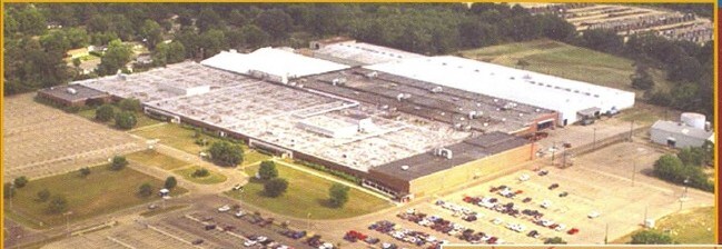


Property Detail
S Mccrary Rd
62W14-03-01000
PT W2 NW4 S MCCRARY RD
Heavyindustrial
LOWNDES
B and X Area of moderate flood hazard, usually the area between the limits of the 100-year and 500-year floods.
Mississippi
2025
23 AC
2025
Vicksburg/Central Area
000406
Other Market Areas
342,684 SF
Columbus, MS
NEARBY LISTINGS FOR SALE OR LEASE
DEMOGRAPHICS near S Mccrary Rd
1 mile
3 mile
5 mile
2025 Total Population
4,175
21,595
33,861
2030 Population
3,977
21,260
33,191
Pop Growth 2025-2030
(4.74%)
(1.55%)
(1.98%)
Average Age
40
39
40
2025 Total Households
1,567
8,645
13,822
HH Growth 2025-2030
(5.11%)
(1.53%)
(1.98%)
Median Household Inc
$31,769
$32,508
$43,993
Avg Household Size
2.40
2.30
2.30
2025 Avg HH Vehicles
2.00
2.00
2.00
Median Home Value
$105,571
$126,228
$159,410
Median Year Built
1976
1974
1978
Nearby Places
Map Layers
Map Styles
 Street
 Aerial
Transit
 Traffic
 Biking
Places
Listings with unknown addresses are not visible on the map
- Restaurants
- Banks
- Shops
- Fitness
- Groceries
PUBLIC TRANSPORTATION
AIRPORT
Golden Triangle Regional
Drive
Walk
Distance
Golden Triangle Regional
28 min
16.2 mi
Freight Ports
Port of Mobile
Drive
Walk
Distance
Port of Mobile
266 min
225.7 mi
SALE & LEASE HISTORY
LISTING DATE
SALE/LEASE

Nov 01, 2016
For Sale
Nearby Properties
Address
Land Use
TOTAL SIZE
Lot Size
Zoning
Address
Land Use
TOTAL SIZE
Lot Size
Zoning
13,500 SF
12.20 AC
Address
Land Use
TOTAL SIZE
Lot Size
Zoning
38,000 SF
1.80 AC
Address
Land Use
TOTAL SIZE
Lot Size
Zoning
11,402 SF
30.30 AC
Address
Land Use
TOTAL SIZE
Lot Size
Zoning
16,589 SF
47.50 AC
Address
Land Use
TOTAL SIZE
Lot Size
Zoning
59,891 SF
9.30 AC
Address
Land Use
TOTAL SIZE
Lot Size
Zoning
134,799 SF
15.29 AC
Address
Land Use
TOTAL SIZE
Lot Size
Zoning
2,044 SF
12.90 AC
Address
Land Use
TOTAL SIZE
Lot Size
Zoning
5,280 SF
9.70 AC
Address
Land Use
TOTAL SIZE
Lot Size
Zoning
10,512 SF
1.31 AC
Address
Land Use
TOTAL SIZE
Lot Size
Zoning
5,400 SF
0.36 AC
Address
Land Use
TOTAL SIZE
Lot Size
Zoning
2,703 SF
3 AC
Address
Land Use
TOTAL SIZE
Lot Size
Zoning
1,976 SF
15.90 AC
Address
Land Use
TOTAL SIZE
Lot Size
Zoning
2,778 SF
11.80 AC
Address
Land Use
TOTAL SIZE
Lot Size
Zoning
4,000 SF
Address
Land Use
TOTAL SIZE
Lot Size
Zoning
136.40 AC
Address
Land Use
TOTAL SIZE
Lot Size
Zoning
2,503 SF
13.80 AC
Address
Land Use
TOTAL SIZE
Lot Size
Zoning
12.20 AC
Address
Land Use
TOTAL SIZE
Lot Size
Zoning
12,092 SF
1.70 AC
Address
Land Use
TOTAL SIZE
Lot Size
Zoning
14,000 SF
5 AC
Address
Land Use
TOTAL SIZE
Lot Size
Zoning
24,000 SF
18.30 AC
Address
Land Use
TOTAL SIZE
Lot Size
Zoning
2,856 SF
28.60 AC
Address
Land Use
TOTAL SIZE
Lot Size
Zoning
42,666 SF
2 AC
Address
Land Use
TOTAL SIZE
Lot Size
Zoning
160,360 SF
6.50 AC
Address
Land Use
TOTAL SIZE
Lot Size
Zoning
45,816 SF
7.66 AC
Address
Land Use
TOTAL SIZE
Lot Size
Zoning
6,202 SF
6.50 AC
Address
Land Use
TOTAL SIZE
Lot Size
Zoning
Address
Land Use
TOTAL SIZE
Lot Size
Zoning
33,366 SF
0.03 AC
Address
Land Use
TOTAL SIZE
Lot Size
Zoning
3,120 SF
5 AC
Address
Land Use
TOTAL SIZE
Lot Size
Zoning
13,085 SF
0.20 AC
Address
Land Use
TOTAL SIZE
Lot Size
Zoning
28,881 SF
1.28 AC
The World's #1 Commercial Real Estate Marketplace
Connect with us
© 2026 CoStar Group
The information above has been obtained from sources believed reliable. While we do not doubt its accuracy we have not verified it and make no guarantee, warranty or representation about it. It is your responsibility to independently confirm its accuracy and completeness. Any projections, opinions, assumptions, or estimates used are for example only and do not represent the current or future performance of the property. The value of this transaction to you depends on tax and other factors which should be evaluated by your tax, financial, and legal advisors. You and your advisors should conduct a careful, independent investigation of the property to determine to your satisfaction the suitability of the property for your needs.