Property Record
S Oates St, Dothan, AL 36301

Property Detail
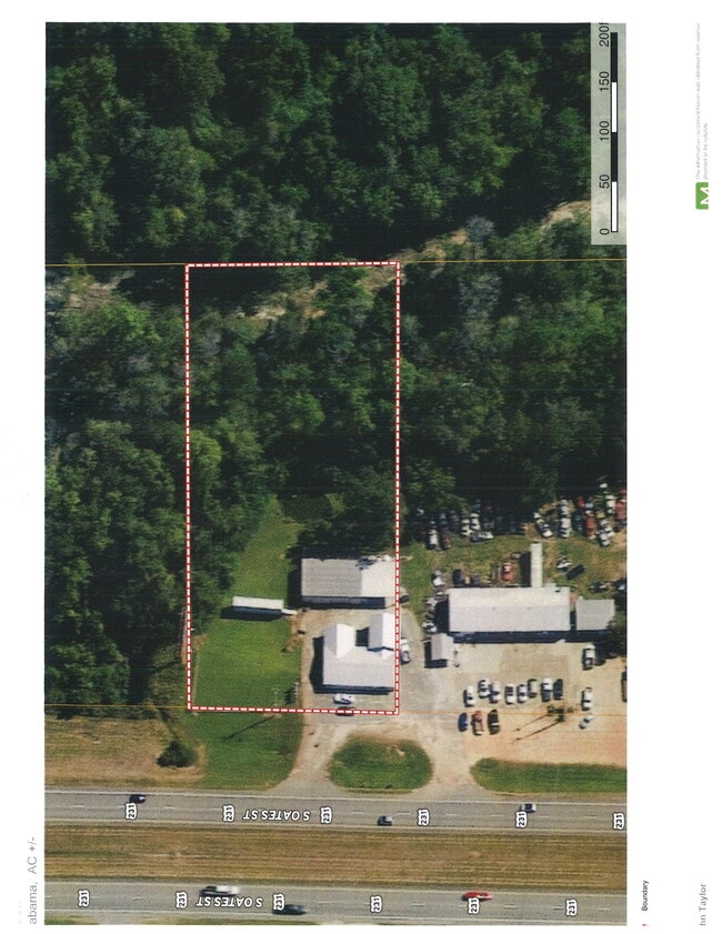
S Oates St
17-06-14-0-000-004-007
PT OF SE QTR OF NE QTR BEG AT THE SE COR S1
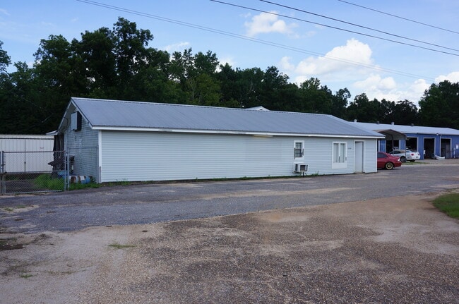
Officebuilding
HOUSTON
AE The base floodplain where base flood elevations are provided. AE Zones are now used on new format FIRMs instead of A1-A30 Zones.
Alabama
2025
1.55 AC
2025
Dothan/Enterprise
041100
Other Market Areas
2,280 SF
Dothan, AL
NEARBY LISTINGS FOR SALE OR LEASE
DEMOGRAPHICS near S Oates St
1 mile
3 mile
5 mile
2025 Total Population
1,022
10,339
39,183
2030 Population
1,051
10,638
39,915
Pop Growth 2025-2030
+ 2.84%
+ 2.89%
+ 1.87%
Average Age
40
40
40
2025 Total Households
417
4,287
15,939
HH Growth 2025-2030
+ 2.88%
+ 2.85%
+ 1.89%
Median Household Inc
$53,148
$61,046
$55,314
Avg Household Size
2.40
2.40
2.40
2025 Avg HH Vehicles
2.00
2.00
2.00
Median Home Value
$232,812
$209,530
$178,424
Median Year Built
1992
1992
1983
Nearby Places
Map Layers
Map Styles
 Street
 Aerial
Transit
 Traffic
 Biking
Places
Listings with unknown addresses are not visible on the map
- Restaurants
- Banks
- Shops
- Fitness
- Groceries
PUBLIC TRANSPORTATION
AIRPORT
Dothan Regional
Drive
Walk
Distance
Dothan Regional
23 min
13.1 mi
SALE & LEASE HISTORY
LISTING DATE
SALE/LEASE

Dec 28, 2022
For Sale
Aug 15, 2022
For Sale
Nearby Properties
Address
Land Use
TOTAL SIZE
Lot Size
Zoning
Address
Land Use
TOTAL SIZE
Lot Size
Zoning
187,423 SF
22.30 AC
Address
Land Use
TOTAL SIZE
Lot Size
Zoning
244,027 SF
Address
Land Use
TOTAL SIZE
Lot Size
Zoning
1,764 SF
8.10 AC
Address
Land Use
TOTAL SIZE
Lot Size
Zoning
10,054 SF
9.20 AC
Address
Land Use
TOTAL SIZE
Lot Size
Zoning
Address
Land Use
TOTAL SIZE
Lot Size
Zoning
120,000 SF
32 AC
Address
Land Use
TOTAL SIZE
Lot Size
Zoning
19,189 SF
5.26 AC
Address
Land Use
TOTAL SIZE
Lot Size
Zoning
48,628 SF
5.13 AC
Address
Land Use
TOTAL SIZE
Lot Size
Zoning
3,513 SF
180.86 AC
Address
Land Use
TOTAL SIZE
Lot Size
Zoning
1,096 SF
5 AC
Address
Land Use
TOTAL SIZE
Lot Size
Zoning
39,320 SF
2.86 AC
Address
Land Use
TOTAL SIZE
Lot Size
Zoning
34,474 SF
6.28 AC
Address
Land Use
TOTAL SIZE
Lot Size
Zoning
18,786 SF
12 AC
Address
Land Use
TOTAL SIZE
Lot Size
Zoning
15,352 SF
7.69 AC
Address
Land Use
TOTAL SIZE
Lot Size
Zoning
15,068 SF
1.80 AC
Address
Land Use
TOTAL SIZE
Lot Size
Zoning
15,050 SF
1.90 AC
Address
Land Use
TOTAL SIZE
Lot Size
Zoning
56,032 SF
6.80 AC
Address
Land Use
TOTAL SIZE
Lot Size
Zoning
30,860 SF
5.33 AC
Address
Land Use
TOTAL SIZE
Lot Size
Zoning
11,772 SF
20.61 AC
Address
Land Use
TOTAL SIZE
Lot Size
Zoning
2,746 SF
2.61 AC
Address
Land Use
TOTAL SIZE
Lot Size
Zoning
22,996 SF
5.99 AC
Address
Land Use
TOTAL SIZE
Lot Size
Zoning
Address
Land Use
TOTAL SIZE
Lot Size
Zoning
3,060 SF
3.75 AC
Address
Land Use
TOTAL SIZE
Lot Size
Zoning
24,480 SF
4.75 AC
Address
Land Use
TOTAL SIZE
Lot Size
Zoning
41,655 SF
2.49 AC
Address
Land Use
TOTAL SIZE
Lot Size
Zoning
24,185 SF
2.48 AC
Address
Land Use
TOTAL SIZE
Lot Size
Zoning
44,326 SF
3.19 AC
Address
Land Use
TOTAL SIZE
Lot Size
Zoning
620 SF
81 AC
Address
Land Use
TOTAL SIZE
Lot Size
Zoning
21,025 SF
2.78 AC
Address
Land Use
TOTAL SIZE
Lot Size
Zoning
21,598 SF
1.26 AC
The World's #1 Commercial Real Estate Marketplace
Connect with us
© 2026 CoStar Group
The information above has been obtained from sources believed reliable. While we do not doubt its accuracy we have not verified it and make no guarantee, warranty or representation about it. It is your responsibility to independently confirm its accuracy and completeness. Any projections, opinions, assumptions, or estimates used are for example only and do not represent the current or future performance of the property. The value of this transaction to you depends on tax and other factors which should be evaluated by your tax, financial, and legal advisors. You and your advisors should conduct a careful, independent investigation of the property to determine to your satisfaction the suitability of the property for your needs.