Property Record
S Peart Rd, Casa Grande, AZ 85193

NEARBY LISTINGS FOR SALE OR LEASE
-
-
View all Casa Grande listings for sale on LoopNet.com
Property Detail
S Peart Rd
Phoenix-Mesa-Scottsdale, AZ
Surveys
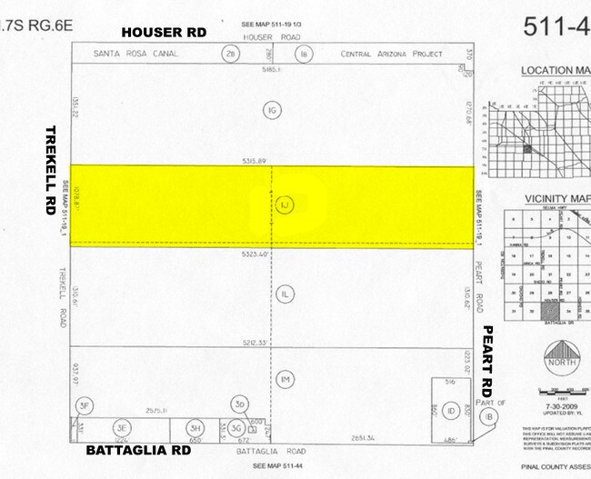
511-40-001J
BEG @ W/4 COR SEC 33-7S-6E TH N-1016.91 TH E-5315.89 TH S-1016.98 TH S-61.96 TH W-5323.4 TH N-61.96 TO POB, AKA: PARCEL 3A-2 IN BO OK 23 OF SURVEYS PAGE 10, 131.77 AC
Farms
Pinal
A
Arizona
04021C1565E
131.77 AC
2024
Pinal County
2025
Phoenix
001500
DEMOGRAPHICS near S Peart Rd
1 Mile
3 Mile
5 Mile
2024 Total Population
5
3,029
16,886
2029 Population
7
3,900
21,854
Pop Growth 2024-2029
+ 40.00%
+ 28.76%
+ 29.42%
Average Age
0
39
42
2024 Total Households
2
1,048
6,546
HH Growth 2024-2029
0.00%
+ 28.53%
+ 29.24%
Median Household Inc
$0
$35,278
$45,901
Avg Household Size
2.00
2.80
2.50
2024 Avg HH Vehicles
3.00
1.00
2.00
Median Home Value
$250,000
$125,287
$159,477
Median Year Built
2005
2005
2004
Nearby Places
Map Layers
Map Styles
 Street
 Aerial
- Restaurants
- Banks
- Shops
- Fitness
- Groceries
Nearby Properties
Address
Land Use
TOTAL SIZE
Lot Size
Zoning
Address
Land Use
TOTAL SIZE
Lot Size
Zoning
21.71 AC
Address
Land Use
TOTAL SIZE
Lot Size
Zoning
49,020 SF
4.06 AC
CI1
Address
Land Use
TOTAL SIZE
Lot Size
Zoning
55,470 SF
2.69 AC
CI1
Address
Land Use
TOTAL SIZE
Lot Size
Zoning
161.76 AC
Address
Land Use
TOTAL SIZE
Lot Size
Zoning
5,230 SF
2.15 AC
Address
Land Use
TOTAL SIZE
Lot Size
Zoning
602.40 AC
Address
Land Use
TOTAL SIZE
Lot Size
Zoning
160 AC
GR
Address
Land Use
TOTAL SIZE
Lot Size
Zoning
7,796 SF
1 AC
Address
Land Use
TOTAL SIZE
Lot Size
Zoning
6,000 SF
2.03 AC
Address
Land Use
TOTAL SIZE
Lot Size
Zoning
7,200 SF
0.67 AC
CI1
Address
Land Use
TOTAL SIZE
Lot Size
Zoning
65.04 AC
GR
Address
Land Use
TOTAL SIZE
Lot Size
Zoning
63.87 AC
GR
Address
Land Use
TOTAL SIZE
Lot Size
Zoning
45.08 AC
GR
Address
Land Use
TOTAL SIZE
Lot Size
Zoning
1,992 SF
1.42 AC
Address
Land Use
TOTAL SIZE
Lot Size
Zoning
165 AC
UNDESIGNAT
Address
Land Use
TOTAL SIZE
Lot Size
Zoning
4.50 AC
CI1
Address
Land Use
TOTAL SIZE
Lot Size
Zoning
160 AC
UNDESIGNAT
Address
Land Use
TOTAL SIZE
Lot Size
Zoning
12,700 SF
1 AC
Address
Land Use
TOTAL SIZE
Lot Size
Zoning
125.45 AC
UNDESIGNAT
Address
Land Use
TOTAL SIZE
Lot Size
Zoning
2,246 SF
214.28 AC
UNDESIGNAT
The World's #1 Commercial Real Estate Marketplace
Connect with us
© 2025 CoStar Group
The information above has been obtained from sources believed reliable. While we do not doubt its accuracy we have not verified it and make no guarantee, warranty or representation about it. It is your responsibility to independently confirm its accuracy and completeness. Any projections, opinions, assumptions, or estimates used are for example only and do not represent the current or future performance of the property. The value of this transaction to you depends on tax and other factors which should be evaluated by your tax, financial, and legal advisors. You and your advisors should conduct a careful, independent investigation of the property to determine to your satisfaction the suitability of the property for your needs.