Property Record
S Peoria Ave E, Tulsa, OK 74136
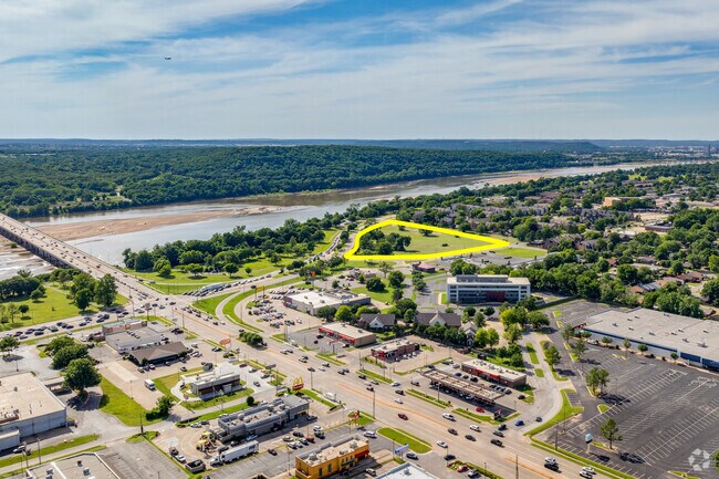

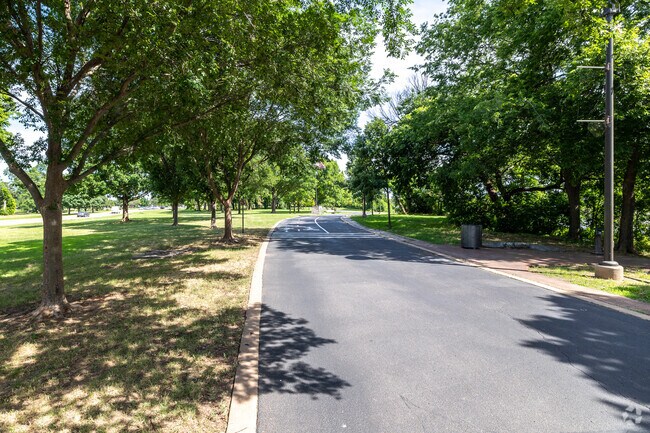
This Property Is For Sale
Property Detail
S Peoria Ave E
Tulsa, OK
PRT SE BEG 1485N & 50W & 493.16S SECR SE TH CRV RT230.90 SW70.06 CRV LF217.09 N113.84 E54.12 S22 E125 N22 E50 TO POB SEC 1 18 12 1.011ACS
98201-82-01-12890
TULSA
Commercialacreage
Oklahoma
CH
4,5
C and X Area of minimal flood hazard, usually depicted on FIRMs as above the 500-year flood level.
1.01 AC
2025
South Central
2025
Tulsa
007611
NEARBY LISTINGS FOR SALE OR LEASE
DEMOGRAPHICS near S Peoria Ave E
1 mile
3 mile
5 mile
2025 Total Population
12,908
69,931
171,109
2030 Population
13,383
71,987
176,176
Pop Growth 2025-2030
+ 3.68%
+ 2.94%
+ 2.96%
Average Age
36
39
40
2025 Total Households
6,504
31,831
74,760
HH Growth 2025-2030
+ 3.72%
+ 3.02%
+ 3.06%
Median Household Inc
$36,331
$55,970
$70,009
Avg Household Size
1.90
2.10
2.20
2025 Avg HH Vehicles
1.00
2.00
2.00
Median Home Value
$134,863
$268,151
$297,111
Median Year Built
1980
1976
1976
Nearby Places
Map Layers
Map Styles
 Street
 Aerial
Transit
 Traffic
 Biking
Places
Listings with unknown addresses are not visible on the map
- Restaurants
- Banks
- Shops
- Fitness
- Groceries
PUBLIC TRANSPORTATION
AIRPORT
Tulsa International
Drive
Walk
Distance
Tulsa International
27 min
17.9 mi
Nearby Properties
Address
Land Use
TOTAL SIZE
Lot Size
Zoning
Address
Land Use
TOTAL SIZE
Lot Size
Zoning
1,584,609 SF
84.41 AC
AG
Address
Land Use
TOTAL SIZE
Lot Size
Zoning
790,247 SF
149.86 AC
RS3
Address
Land Use
TOTAL SIZE
Lot Size
Zoning
358,576 SF
38.21 AC
RM1
Address
Land Use
TOTAL SIZE
Lot Size
Zoning
310,629 SF
19.19 AC
OM
Address
Land Use
TOTAL SIZE
Lot Size
Zoning
290,963 SF
10.77 AC
RM1
Address
Land Use
TOTAL SIZE
Lot Size
Zoning
325 SF
44.06 AC
RM2
Address
Land Use
TOTAL SIZE
Lot Size
Zoning
415.28 AC
IL
Address
Land Use
TOTAL SIZE
Lot Size
Zoning
266,675 SF
12.31 AC
RM1
Address
Land Use
TOTAL SIZE
Lot Size
Zoning
119,056 SF
28.06 AC
CM
Address
Land Use
TOTAL SIZE
Lot Size
Zoning
147,881 SF
35.20 AC
RS2
Address
Land Use
TOTAL SIZE
Lot Size
Zoning
301,267 SF
25.06 AC
IL
Address
Land Use
TOTAL SIZE
Lot Size
Zoning
98,590 SF
6.41 AC
OM
Address
Land Use
TOTAL SIZE
Lot Size
Zoning
107,538 SF
19.74 AC
OM
Address
Land Use
TOTAL SIZE
Lot Size
Zoning
62,000 SF
7.20 AC
OM
Address
Land Use
TOTAL SIZE
Lot Size
Zoning
15.98 AC
OMH
Address
Land Use
TOTAL SIZE
Lot Size
Zoning
56,984 SF
5.54 AC
RS3
Address
Land Use
TOTAL SIZE
Lot Size
Zoning
132,105 SF
9.32 AC
RS3
Address
Land Use
TOTAL SIZE
Lot Size
Zoning
58,864 SF
5.18 AC
RS3
Address
Land Use
TOTAL SIZE
Lot Size
Zoning
62,792 SF
5.18 AC
RM1
Address
Land Use
TOTAL SIZE
Lot Size
Zoning
53,220 SF
4.93 AC
CH
Address
Land Use
TOTAL SIZE
Lot Size
Zoning
30,418 SF
7.86 AC
CM
Address
Land Use
TOTAL SIZE
Lot Size
Zoning
1,011,877 SF
5.55 AC
CH
Address
Land Use
TOTAL SIZE
Lot Size
Zoning
330,521 SF
22.04 AC
PUD
Address
Land Use
TOTAL SIZE
Lot Size
Zoning
84,791 SF
8.04 AC
RS3
Address
Land Use
TOTAL SIZE
Lot Size
Zoning
35,785 SF
4.55 AC
RS1
Address
Land Use
TOTAL SIZE
Lot Size
Zoning
1 SF
11.34 AC
CS
Address
Land Use
TOTAL SIZE
Lot Size
Zoning
51,423 SF
1.03 AC
OM
Address
Land Use
TOTAL SIZE
Lot Size
Zoning
110,382 SF
9.81 AC
RS3
Address
Land Use
TOTAL SIZE
Lot Size
Zoning
2,178,542 SF
46.63 AC
OM
Address
Land Use
TOTAL SIZE
Lot Size
Zoning
35,845 SF
14.38 AC
CS
The World's #1 Commercial Real Estate Marketplace
Connect with us
© 2026 CoStar Group
The information above has been obtained from sources believed reliable. While we do not doubt its accuracy we have not verified it and make no guarantee, warranty or representation about it. It is your responsibility to independently confirm its accuracy and completeness. Any projections, opinions, assumptions, or estimates used are for example only and do not represent the current or future performance of the property. The value of this transaction to you depends on tax and other factors which should be evaluated by your tax, financial, and legal advisors. You and your advisors should conduct a careful, independent investigation of the property to determine to your satisfaction the suitability of the property for your needs.