Property Record
5 Impact Dr, Greenville, SC 29605


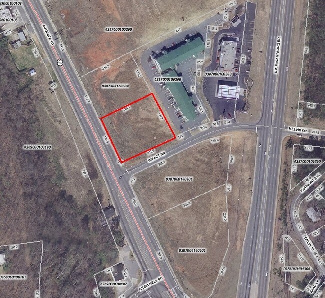
This Property Is For Sale
NEARBY LISTINGS FOR SALE OR LEASE
Property Detail
5 Impact Dr
Greenville-Anderson-Mauldin, SC
MAP 0387.00; B
0387.00-01-003.01
Greenville
Commercialnec
South Carolina
X
003.01
45045C0392F
2.50 AC
2025
Mauldin/Fountain
2024
Greenville/Spartanburg
002103
DEMOGRAPHICS near 5 Impact Dr
1 Mile
3 Mile
5 Mile
2024 Total Population
6,680
42,085
130,351
2029 Population
7,291
46,471
145,362
Pop Growth 2024-2029
+ 9.15%
+ 10.42%
+ 11.52%
Average Age
39
38
39
2024 Total Households
2,685
17,405
56,431
HH Growth 2024-2029
+ 9.24%
+ 10.50%
+ 11.71%
Median Household Inc
$36,035
$60,278
$60,917
Avg Household Size
2.40
2.40
2.20
2024 Avg HH Vehicles
2.00
2.00
2.00
Median Home Value
$121,022
$281,178
$244,847
Median Year Built
1968
1976
1987
Nearby Places
Map Layers
Map Styles
 Street
 Aerial
- Restaurants
- Banks
- Shops
- Fitness
- Groceries
PUBLIC TRANSPORTATION
COMMUTER RAIL
Greenville Amtrak Station (Crescent - Amtrak)
DRIVE
WALK
Distance
Greenville Amtrak Station (Crescent - Amtrak)
14 min
5.9 mi
AIRPORT
Greenville Spartanburg International
DRIVE
WALK
Distance
Greenville Spartanburg International
21 min
12.9 mi
Freight Ports
North Charleston Terminal
DRIVE
WALK
Distance
North Charleston Terminal
227 min
199.3 mi
Nearby Properties
Address
Land Use
TOTAL SIZE
Lot Size
Zoning
Address
Land Use
TOTAL SIZE
Lot Size
Zoning
14.21 AC
RM2
Address
Land Use
TOTAL SIZE
Lot Size
Zoning
0.45 AC
OD
Address
Land Use
TOTAL SIZE
Lot Size
Zoning
15.82 AC
RM
Address
Land Use
TOTAL SIZE
Lot Size
Zoning
12.95 AC
RM3
Address
Land Use
TOTAL SIZE
Lot Size
Zoning
7.03 AC
OD
Address
Land Use
TOTAL SIZE
Lot Size
Zoning
0.47 AC
OD
Address
Land Use
TOTAL SIZE
Lot Size
Zoning
20.30 AC
I1
Address
Land Use
TOTAL SIZE
Lot Size
Zoning
387.84 AC
S1
Address
Land Use
TOTAL SIZE
Lot Size
Zoning
15.29 AC
RM2
Address
Land Use
TOTAL SIZE
Lot Size
Zoning
6.17 AC
Address
Land Use
TOTAL SIZE
Lot Size
Zoning
114.75 AC
0D
Address
Land Use
TOTAL SIZE
Lot Size
Zoning
333.78 AC
S-1,I-1
Address
Land Use
TOTAL SIZE
Lot Size
Zoning
6.03 AC
OD
Address
Land Use
TOTAL SIZE
Lot Size
Zoning
0.65 AC
OD
Address
Land Use
TOTAL SIZE
Lot Size
Zoning
32.02 AC
R6
Address
Land Use
TOTAL SIZE
Lot Size
Zoning
33.60 AC
I1
Address
Land Use
TOTAL SIZE
Lot Size
Zoning
11.17 AC
C2
Address
Land Use
TOTAL SIZE
Lot Size
Zoning
5.86 AC
RM2
Address
Land Use
TOTAL SIZE
Lot Size
Zoning
6.30 AC
S1
Address
Land Use
TOTAL SIZE
Lot Size
Zoning
Address
Land Use
TOTAL SIZE
Lot Size
Zoning
16.09 AC
S1
Address
Land Use
TOTAL SIZE
Lot Size
Zoning
123.10 AC
0D
Address
Land Use
TOTAL SIZE
Lot Size
Zoning
0.45 AC
OD
Address
Land Use
TOTAL SIZE
Lot Size
Zoning
54.35 AC
I-1
Address
Land Use
TOTAL SIZE
Lot Size
Zoning
108.12 AC
I1
Address
Land Use
TOTAL SIZE
Lot Size
Zoning
8.42 AC
C3
Address
Land Use
TOTAL SIZE
Lot Size
Zoning
112.08 AC
S1
Address
Land Use
TOTAL SIZE
Lot Size
Zoning
5.50 AC
I1
Address
Land Use
TOTAL SIZE
Lot Size
Zoning
2.15 AC
Address
Land Use
TOTAL SIZE
Lot Size
Zoning
2.38 AC
C2,OD
The World's #1 Commercial Real Estate Marketplace
Connect with us
© 2026 CoStar Group
The information above has been obtained from sources believed reliable. While we do not doubt its accuracy we have not verified it and make no guarantee, warranty or representation about it. It is your responsibility to independently confirm its accuracy and completeness. Any projections, opinions, assumptions, or estimates used are for example only and do not represent the current or future performance of the property. The value of this transaction to you depends on tax and other factors which should be evaluated by your tax, financial, and legal advisors. You and your advisors should conduct a careful, independent investigation of the property to determine to your satisfaction the suitability of the property for your needs.