Property Record
S Prairie Rd, Napavine, WA 98532
NEARBY LISTINGS FOR SALE OR LEASE
-
-
View all Napavine listings for sale on LoopNet.com
Property Detail
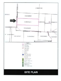
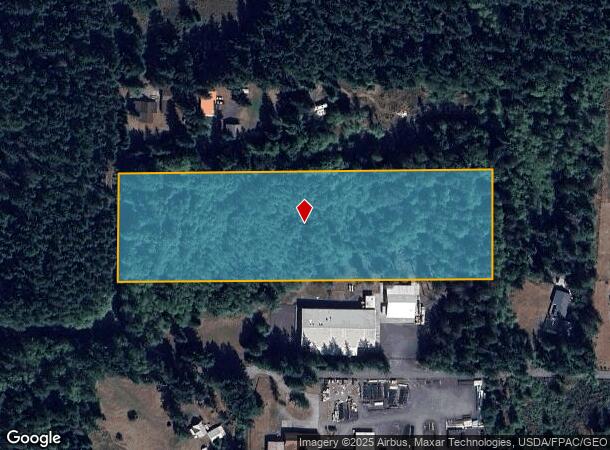
S Prairie Rd
Other Market Areas
Segregation Surv Tr 2
Centralia, WA
SECTION 09 TOWNSHIP 12N RANGE 01W PTN SE4 TRACT 2 ROS AFN 2001885
014506-004-000
Lewis
Lightindustrial
Washington
2024
1,2
2025
6.66 AC
971000
Washington State Area
DEMOGRAPHICS near S Prairie Rd
1 Mile
3 Mile
5 Mile
2024 Total Population
366
2,575
6,855
2029 Population
402
2,827
7,514
Pop Growth 2024-2029
+ 9.84%
+ 9.79%
+ 9.61%
Average Age
45
44
44
2024 Total Households
138
965
2,542
HH Growth 2024-2029
+ 9.42%
+ 9.84%
+ 9.68%
Median Household Inc
$81,250
$80,973
$81,666
Avg Household Size
2.60
2.60
2.60
2024 Avg HH Vehicles
3.00
3.00
3.00
Median Home Value
$391,176
$370,083
$368,284
Median Year Built
1987
1985
1986
Nearby Places
Map Layers
Map Styles
 Street
 Aerial
- Restaurants
- Banks
- Shops
- Fitness
- Groceries
Nearby Properties
Address
Land Use
TOTAL SIZE
Lot Size
Zoning
Address
Land Use
TOTAL SIZE
Lot Size
Zoning
1,952 SF
49.25 AC
ARL
Address
Land Use
TOTAL SIZE
Lot Size
Zoning
20,000 SF
6.71 AC
RAI
Address
Land Use
TOTAL SIZE
Lot Size
Zoning
55 AC
ARL
Address
Land Use
TOTAL SIZE
Lot Size
Zoning
7,300 SF
35.29 AC
ARL
Address
Land Use
TOTAL SIZE
Lot Size
Zoning
1,366 SF
6.46 AC
FC
Address
Land Use
TOTAL SIZE
Lot Size
Zoning
1,860 SF
19.34 AC
ARL
Address
Land Use
TOTAL SIZE
Lot Size
Zoning
4,848 SF
19.94 AC
ARL
Address
Land Use
TOTAL SIZE
Lot Size
Zoning
4,718 SF
5.99 AC
RDD5
Address
Land Use
TOTAL SIZE
Lot Size
Zoning
5,271 SF
20.90 AC
RDD20
Address
Land Use
TOTAL SIZE
Lot Size
Zoning
29,182 SF
10.07 AC
RAI
Address
Land Use
TOTAL SIZE
Lot Size
Zoning
3,828 SF
12.19 AC
PARK
Address
Land Use
TOTAL SIZE
Lot Size
Zoning
1,872 SF
58.40 AC
ARL
Address
Land Use
TOTAL SIZE
Lot Size
Zoning
16,580 SF
2.68 AC
CC
Address
Land Use
TOTAL SIZE
Lot Size
Zoning
2,626 SF
55.72 AC
ARL
Address
Land Use
TOTAL SIZE
Lot Size
Zoning
2,712 SF
8.69 AC
RDD10
Address
Land Use
TOTAL SIZE
Lot Size
Zoning
3,315 SF
39.27 AC
ARL
Address
Land Use
TOTAL SIZE
Lot Size
Zoning
5,360 SF
5 AC
RDD5
Address
Land Use
TOTAL SIZE
Lot Size
Zoning
1,782 SF
6.13 AC
ARL
Address
Land Use
TOTAL SIZE
Lot Size
Zoning
2,824 SF
7.05 AC
RDD20
Address
Land Use
TOTAL SIZE
Lot Size
Zoning
160 AC
RDD20
Address
Land Use
TOTAL SIZE
Lot Size
Zoning
3,314 SF
87.42 AC
RDD20
Address
Land Use
TOTAL SIZE
Lot Size
Zoning
15.92 AC
Address
Land Use
TOTAL SIZE
Lot Size
Zoning
2,430 SF
41 AC
RDD20
Address
Land Use
TOTAL SIZE
Lot Size
Zoning
10.07 AC
Address
Land Use
TOTAL SIZE
Lot Size
Zoning
20.22 AC
RDD20
Address
Land Use
TOTAL SIZE
Lot Size
Zoning
1,736 SF
28.18 AC
FOREST
Address
Land Use
TOTAL SIZE
Lot Size
Zoning
1,512 SF
39.50 AC
ARL
Address
Land Use
TOTAL SIZE
Lot Size
Zoning
1,968 SF
28.69 AC
Address
Land Use
TOTAL SIZE
Lot Size
Zoning
4,128 SF
21.80 AC
ARL
Address
Land Use
TOTAL SIZE
Lot Size
Zoning
6,880 SF
19.65 AC
RAI
The World's #1 Commercial Real Estate Marketplace
Connect with us
© 2025 CoStar Group
The information above has been obtained from sources believed reliable. While we do not doubt its accuracy we have not verified it and make no guarantee, warranty or representation about it. It is your responsibility to independently confirm its accuracy and completeness. Any projections, opinions, assumptions, or estimates used are for example only and do not represent the current or future performance of the property. The value of this transaction to you depends on tax and other factors which should be evaluated by your tax, financial, and legal advisors. You and your advisors should conduct a careful, independent investigation of the property to determine to your satisfaction the suitability of the property for your needs.