Property Record
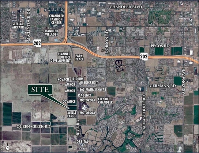
0 S Price Rd, Chandler, AZ 85286

Property Detail
0 S Price Rd
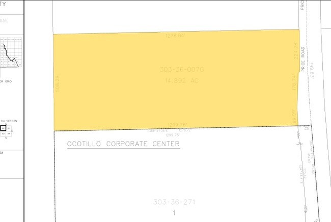
303-36-007G
BEG AT W4 COR SEC7 TH E 1278.04F TO PT ON CUR CONC ELY TH SLY ALG ARC SD CUR 402.93F TH S 03D 33M E 105.77F TH W 1299.76F TO PT ON WLY LN SD SEC 7 TH N 508.29F TO TPOB EX ANY PT RD LY WI/IN P/F 03-0757693 TH/OF
Farms
MARICOPA
PAD
Arizona
C and X Area of minimal flood hazard, usually depicted on FIRMs as above the 500-year flood level.
14.89 AC
2025
Chandler
2025
Phoenix
812400
Phoenix-Mesa-Chandler, AZ
NEARBY LISTINGS FOR SALE OR LEASE
DEMOGRAPHICS near 0 S Price Rd
1 mile
3 mile
5 mile
2025 Total Population
5,478
71,793
201,061
2030 Population
5,689
74,655
208,126
Pop Growth 2025-2030
+ 3.85%
+ 3.99%
+ 3.51%
Average Age
38
39
41
2025 Total Households
2,255
28,096
78,247
HH Growth 2025-2030
+ 3.90%
+ 4.07%
+ 3.62%
Median Household Inc
$114,154
$110,023
$101,946
Avg Household Size
2.40
2.50
2.50
2025 Avg HH Vehicles
2.00
2.00
2.00
Median Home Value
$701,599
$628,769
$521,034
Median Year Built
2004
2000
1995
Nearby Places
Map Layers
Map Styles
 Street
 Aerial
Layers
 Traffic
 Biking
Places
Listings with unknown addresses are not visible on the map
- Restaurants
- Banks
- Shops
- Fitness
- Groceries
PUBLIC TRANSPORTATION
AIRPORT
Phoenix-Mesa Gateway
Drive
Walk
Distance
Phoenix-Mesa Gateway
24 min
16.1 mi
Phoenix Sky Harbor International
Drive
Walk
Distance
Phoenix Sky Harbor International
26 min
18.6 mi
Freight Ports
Port of San Diego
Drive
Walk
Distance
Port of San Diego
392 min
360.1 mi
Nearby Properties
Address
Land Use
TOTAL SIZE
Lot Size
Zoning
Address
Land Use
TOTAL SIZE
Lot Size
Zoning
221,091 SF
14.76 AC
I-1
Address
Land Use
TOTAL SIZE
Lot Size
Zoning
1,420,114 SF
66.08 AC
PAD
Address
Land Use
TOTAL SIZE
Lot Size
Zoning
71,100 SF
9.07 AC
PAD
Address
Land Use
TOTAL SIZE
Lot Size
Zoning
733,019 SF
13.13 AC
PAD
Address
Land Use
TOTAL SIZE
Lot Size
Zoning
24,739 SF
5.39 AC
PAD
Address
Land Use
TOTAL SIZE
Lot Size
Zoning
51,091 SF
3.59 AC
PAD
Address
Land Use
TOTAL SIZE
Lot Size
Zoning
3,688,548 SF
285.19 AC
PAD
Address
Land Use
TOTAL SIZE
Lot Size
Zoning
687,690 SF
44.05 AC
PAD
Address
Land Use
TOTAL SIZE
Lot Size
Zoning
434,857 SF
36.73 AC
PF
Address
Land Use
TOTAL SIZE
Lot Size
Zoning
724,125 SF
39.23 AC
Address
Land Use
TOTAL SIZE
Lot Size
Zoning
43,044 SF
3.46 AC
PAD
Address
Land Use
TOTAL SIZE
Lot Size
Zoning
774,482 SF
25.50 AC
PAD
Address
Land Use
TOTAL SIZE
Lot Size
Zoning
519,664 SF
20.95 AC
PAD
Address
Land Use
TOTAL SIZE
Lot Size
Zoning
2.57 AC
Address
Land Use
TOTAL SIZE
Lot Size
Zoning
1.83 AC
Address
Land Use
TOTAL SIZE
Lot Size
Zoning
456,122 SF
25.97 AC
PAD
Address
Land Use
TOTAL SIZE
Lot Size
Zoning
24,038 SF
40.27 AC
AG1
Address
Land Use
TOTAL SIZE
Lot Size
Zoning
1.64 AC
Address
Land Use
TOTAL SIZE
Lot Size
Zoning
263,599 SF
18.33 AC
PAD
Address
Land Use
TOTAL SIZE
Lot Size
Zoning
416,098 SF
22.48 AC
Address
Land Use
TOTAL SIZE
Lot Size
Zoning
395,055 SF
8.33 AC
PAD
Address
Land Use
TOTAL SIZE
Lot Size
Zoning
331,556 SF
19.73 AC
PAD
Address
Land Use
TOTAL SIZE
Lot Size
Zoning
374,847 SF
20.84 AC
PAD
Address
Land Use
TOTAL SIZE
Lot Size
Zoning
269,504 SF
8.87 AC
I-1
Address
Land Use
TOTAL SIZE
Lot Size
Zoning
256,618 SF
19.49 AC
PAD
Address
Land Use
TOTAL SIZE
Lot Size
Zoning
58,989 SF
37.62 AC
PAD
Address
Land Use
TOTAL SIZE
Lot Size
Zoning
403,326 SF
8.71 AC
PAD
Address
Land Use
TOTAL SIZE
Lot Size
Zoning
329,305 SF
18.06 AC
PAD
Address
Land Use
TOTAL SIZE
Lot Size
Zoning
444,802 SF
4.17 AC
I-1
The World's #1 Commercial Real Estate Marketplace
Connect with us
© 2026 CoStar Group
The information above has been obtained from sources believed reliable. While we do not doubt its accuracy we have not verified it and make no guarantee, warranty or representation about it. It is your responsibility to independently confirm its accuracy and completeness. Any projections, opinions, assumptions, or estimates used are for example only and do not represent the current or future performance of the property. The value of this transaction to you depends on tax and other factors which should be evaluated by your tax, financial, and legal advisors. You and your advisors should conduct a careful, independent investigation of the property to determine to your satisfaction the suitability of the property for your needs.