Property Record
S Providence Rd, , MO
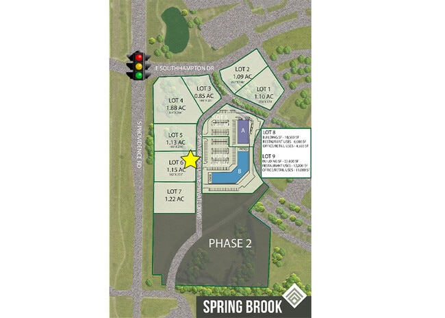

Property Detail
S Providence Rd
Columbia, MO
STATE FARM SUBDIVISION BLOCK 2 SPT LOT 1A
16-904-00-02-001-01
BOONE
Commercialnec
Missouri
B and X Area of moderate flood hazard, usually the area between the limits of the 100-year and 500-year floods.
1
2025
14.30 AC
2025
Columbia/Jefferson City
001106
Other Market Areas
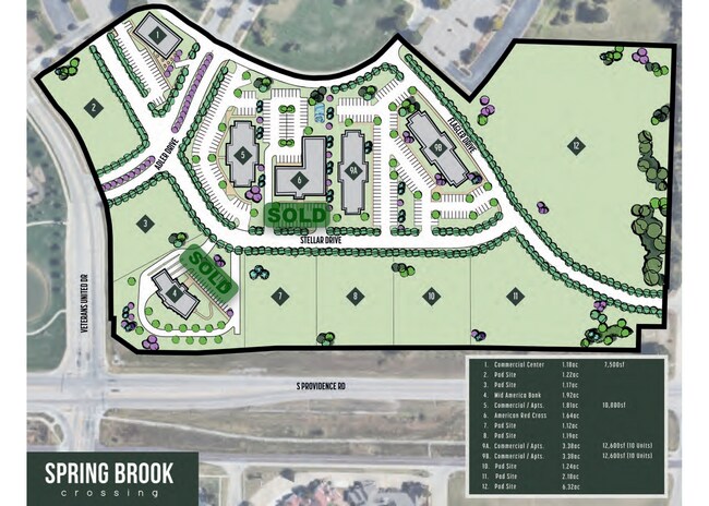
NEARBY LISTINGS FOR SALE OR LEASE
DEMOGRAPHICS near S Providence Rd
1 mile
3 mile
5 mile
2025 Total Population
5,613
42,646
102,075
2030 Population
5,759
43,940
105,891
Pop Growth 2025-2030
+ 2.60%
+ 3.03%
+ 3.74%
Average Age
34
33
35
2025 Total Households
2,562
15,980
41,067
HH Growth 2025-2030
+ 2.77%
+ 3.39%
+ 4.05%
Median Household Inc
$51,446
$62,912
$62,728
Avg Household Size
2.10
2.20
2.20
2025 Avg HH Vehicles
2.00
2.00
2.00
Median Home Value
$327,184
$357,860
$329,684
Median Year Built
1994
1995
1990
Nearby Places
Map Layers
Map Styles
 Street
 Aerial
Transit
 Traffic
 Biking
Places
Listings with unknown addresses are not visible on the map
- Restaurants
- Banks
- Shops
- Fitness
- Groceries
PUBLIC TRANSPORTATION
AIRPORT
Columbia Regional
Drive
Walk
Distance
Columbia Regional
17 min
11.4 mi
Freight Ports
Tulsa Port of Inola
Drive
Walk
Distance
Tulsa Port of Inola
378 min
334.1 mi
SALE & LEASE HISTORY
LISTING DATE
SALE/LEASE

Nov 09, 2022
For Sale
Nearby Properties
Address
Land Use
TOTAL SIZE
Lot Size
Zoning
Address
Land Use
TOTAL SIZE
Lot Size
Zoning
373,370 SF
77.30 AC
O1
Address
Land Use
TOTAL SIZE
Lot Size
Zoning
10,459 SF
39.22 AC
RMH
Address
Land Use
TOTAL SIZE
Lot Size
Zoning
50,304 SF
8.78 AC
C1
Address
Land Use
TOTAL SIZE
Lot Size
Zoning
52,568 SF
9.50 AC
Address
Land Use
TOTAL SIZE
Lot Size
Zoning
70,930 SF
9.66 AC
Address
Land Use
TOTAL SIZE
Lot Size
Zoning
185,585 SF
18.57 AC
Address
Land Use
TOTAL SIZE
Lot Size
Zoning
24,624 SF
21.42 AC
Address
Land Use
TOTAL SIZE
Lot Size
Zoning
3,420 SF
18.60 AC
R3
Address
Land Use
TOTAL SIZE
Lot Size
Zoning
8,678 SF
23.15 AC
R3
Address
Land Use
TOTAL SIZE
Lot Size
Zoning
148,500 SF
22.62 AC
R3
Address
Land Use
TOTAL SIZE
Lot Size
Zoning
119,520 SF
12.56 AC
Address
Land Use
TOTAL SIZE
Lot Size
Zoning
34,357 SF
15.59 AC
Address
Land Use
TOTAL SIZE
Lot Size
Zoning
119,988 SF
8.87 AC
Address
Land Use
TOTAL SIZE
Lot Size
Zoning
136,851 SF
2.23 AC
CP
Address
Land Use
TOTAL SIZE
Lot Size
Zoning
2,922 SF
11.40 AC
PUD1
Address
Land Use
TOTAL SIZE
Lot Size
Zoning
159,984 SF
15.20 AC
R3
Address
Land Use
TOTAL SIZE
Lot Size
Zoning
31,200 SF
14.84 AC
Address
Land Use
TOTAL SIZE
Lot Size
Zoning
13,024 SF
11.90 AC
R3
Address
Land Use
TOTAL SIZE
Lot Size
Zoning
176,300 SF
5.22 AC
Address
Land Use
TOTAL SIZE
Lot Size
Zoning
11.48 AC
Address
Land Use
TOTAL SIZE
Lot Size
Zoning
77,804 SF
7.77 AC
Address
Land Use
TOTAL SIZE
Lot Size
Zoning
3,875 SF
15.03 AC
A1
Address
Land Use
TOTAL SIZE
Lot Size
Zoning
94,185 SF
3.19 AC
C3
Address
Land Use
TOTAL SIZE
Lot Size
Zoning
83,119 SF
6.48 AC
C1
Address
Land Use
TOTAL SIZE
Lot Size
Zoning
68,477 SF
3.55 AC
Address
Land Use
TOTAL SIZE
Lot Size
Zoning
5,920 SF
8.91 AC
R3
Address
Land Use
TOTAL SIZE
Lot Size
Zoning
96,322 SF
9.40 AC
Address
Land Use
TOTAL SIZE
Lot Size
Zoning
13,984 SF
5.08 AC
C1
Address
Land Use
TOTAL SIZE
Lot Size
Zoning
57,738 SF
6.61 AC
C1
Address
Land Use
TOTAL SIZE
Lot Size
Zoning
63,330 SF
6.94 AC
The World's #1 Commercial Real Estate Marketplace
Connect with us
© 2026 CoStar Group
The information above has been obtained from sources believed reliable. While we do not doubt its accuracy we have not verified it and make no guarantee, warranty or representation about it. It is your responsibility to independently confirm its accuracy and completeness. Any projections, opinions, assumptions, or estimates used are for example only and do not represent the current or future performance of the property. The value of this transaction to you depends on tax and other factors which should be evaluated by your tax, financial, and legal advisors. You and your advisors should conduct a careful, independent investigation of the property to determine to your satisfaction the suitability of the property for your needs.