Property Record
S Red Haven Ln, Dover, DE 19901
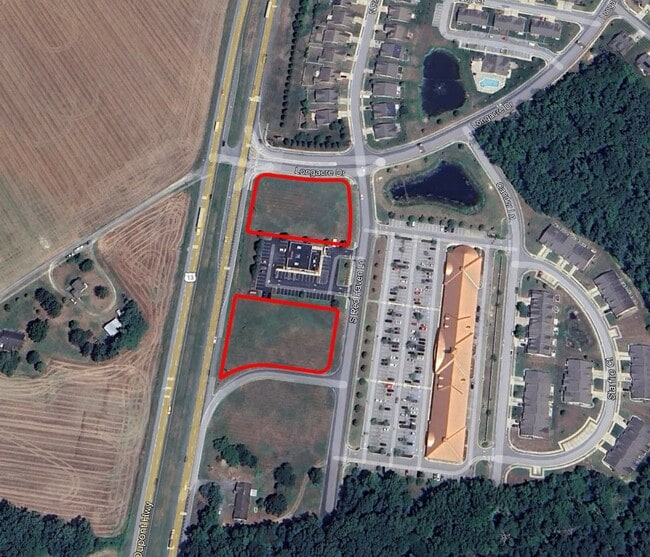

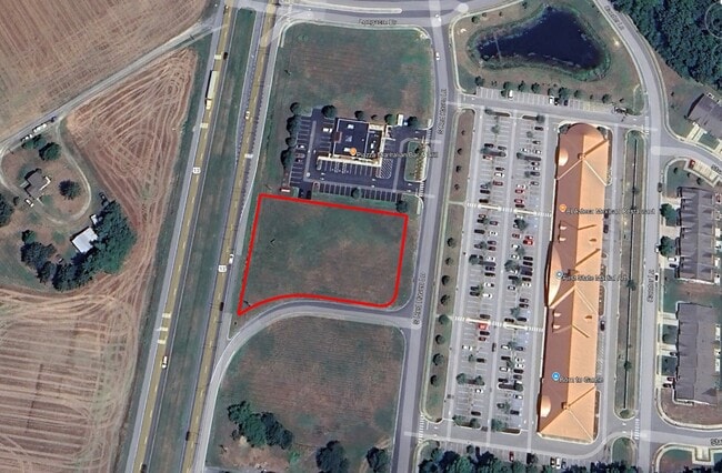
Current Lease Availabilities
Property Detail
S Red Haven Ln
7-00-10304-04-4300-000
SOME INFO KEYED FROM LEGAL DESC, BUT COMPLETE LEGAL NOT CAPTURED
Residentialacreage
KENT
BG
Delaware
B and X Area of moderate flood hazard, usually the area between the limits of the 100-year and 500-year floods.
1 AC
2025
Kent County
2025
Philadelphia
041300
Dover, DE
NEARBY LISTINGS FOR SALE OR LEASE
DEMOGRAPHICS near S Red Haven Ln
1 mile
3 mile
5 mile
2025 Total Population
1,995
26,388
61,733
2030 Population
2,113
27,614
64,600
Pop Growth 2025-2030
+ 5.91%
+ 4.65%
+ 4.64%
Average Age
43
41
40
2025 Total Households
731
9,538
22,909
HH Growth 2025-2030
+ 5.88%
+ 4.72%
+ 4.99%
Median Household Inc
$57,610
$82,259
$80,223
Avg Household Size
2.60
2.70
2.60
2025 Avg HH Vehicles
2.00
2.00
2.00
Median Home Value
$403,261
$352,338
$344,016
Median Year Built
1995
1998
1995
Nearby Places
Map Layers
Map Styles
 Street
 Aerial
Layers
 Traffic
 Biking
Places
Listings with unknown addresses are not visible on the map
- Restaurants
- Banks
- Shops
- Fitness
- Groceries
Nearby Properties
Address
Land Use
TOTAL SIZE
Lot Size
Zoning
Address
Land Use
TOTAL SIZE
Lot Size
Zoning
494,672 SF
35.80 AC
NA
Address
Land Use
TOTAL SIZE
Lot Size
Zoning
309,792 SF
108.80 AC
AC
Address
Land Use
TOTAL SIZE
Lot Size
Zoning
135,552 SF
39.05 AC
AC
Address
Land Use
TOTAL SIZE
Lot Size
Zoning
109,262 SF
15.03 AC
NA
Address
Land Use
TOTAL SIZE
Lot Size
Zoning
5,529 SF
83.30 AC
NA
Address
Land Use
TOTAL SIZE
Lot Size
Zoning
190,988 SF
19.90 AC
NA
Address
Land Use
TOTAL SIZE
Lot Size
Zoning
62,728 SF
25 AC
AC
Address
Land Use
TOTAL SIZE
Lot Size
Zoning
Address
Land Use
TOTAL SIZE
Lot Size
Zoning
91,738 SF
22.17 AC
R1
Address
Land Use
TOTAL SIZE
Lot Size
Zoning
125,394 SF
19.10 AC
RS1
Address
Land Use
TOTAL SIZE
Lot Size
Zoning
58,026 SF
17 AC
NA
Address
Land Use
TOTAL SIZE
Lot Size
Zoning
60,878 SF
6.80 AC
BG
Address
Land Use
TOTAL SIZE
Lot Size
Zoning
33,674 SF
20 AC
AC
Address
Land Use
TOTAL SIZE
Lot Size
Zoning
23,924 SF
17.70 AC
RS1
Address
Land Use
TOTAL SIZE
Lot Size
Zoning
39,141 SF
4 AC
BG
Address
Land Use
TOTAL SIZE
Lot Size
Zoning
42,765 SF
9.10 AC
NA
Address
Land Use
TOTAL SIZE
Lot Size
Zoning
9,384 SF
40.17 AC
AC
Address
Land Use
TOTAL SIZE
Lot Size
Zoning
101,620 SF
16.32 AC
NA
Address
Land Use
TOTAL SIZE
Lot Size
Zoning
19,352 SF
14.77 AC
RM
Address
Land Use
TOTAL SIZE
Lot Size
Zoning
24.80 AC
RMH
Address
Land Use
TOTAL SIZE
Lot Size
Zoning
49,061 SF
7.26 AC
RMH
Address
Land Use
TOTAL SIZE
Lot Size
Zoning
27,297 SF
5.20 AC
NA
Address
Land Use
TOTAL SIZE
Lot Size
Zoning
50,655 SF
5.40 AC
NA
Address
Land Use
TOTAL SIZE
Lot Size
Zoning
82.20 AC
AC
Address
Land Use
TOTAL SIZE
Lot Size
Zoning
9,040 SF
6.30 AC
BG
Address
Land Use
TOTAL SIZE
Lot Size
Zoning
12,100 SF
5.29 AC
BG
Address
Land Use
TOTAL SIZE
Lot Size
Zoning
1,720 SF
71.20 AC
AR
Address
Land Use
TOTAL SIZE
Lot Size
Zoning
31,465 SF
3.36 AC
NA
Address
Land Use
TOTAL SIZE
Lot Size
Zoning
11,421 SF
1.70 AC
NA
Address
Land Use
TOTAL SIZE
Lot Size
Zoning
17,025 SF
2.13 AC
NA
The World's #1 Commercial Real Estate Marketplace
Connect with us
© 2026 CoStar Group
The information above has been obtained from sources believed reliable. While we do not doubt its accuracy we have not verified it and make no guarantee, warranty or representation about it. It is your responsibility to independently confirm its accuracy and completeness. Any projections, opinions, assumptions, or estimates used are for example only and do not represent the current or future performance of the property. The value of this transaction to you depends on tax and other factors which should be evaluated by your tax, financial, and legal advisors. You and your advisors should conduct a careful, independent investigation of the property to determine to your satisfaction the suitability of the property for your needs.