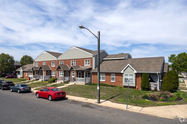
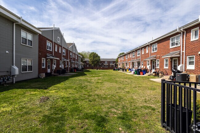
Property Record
S S 20Th & Berwick St, Camden, NJ 08105
NEARBY LISTINGS FOR SALE OR LEASE
Property Detail
S S 20Th & Berwick St
Philadelphia-Camden-Wilmington, PA-NJ-DE-MD
FACILITY NAME: PUBLIC HOUSING
08-01223-01-00001
Camden
Taxexempt
New Jersey
AE
2
34007C0028F
2.38 AC
0
Marlton
2025
Philadelphia
601101
DEMOGRAPHICS near S S 20Th & Berwick St
1 Mile
3 Mile
5 Mile
2024 Total Population
26,082
169,435
714,340
2029 Population
26,362
169,575
703,227
Pop Growth 2024-2029
+ 1.07%
+ 0.08%
(1.56%)
Average Age
35
37
37
2024 Total Households
8,411
66,917
299,644
HH Growth 2024-2029
+ 1.13%
(0.17%)
(1.83%)
Median Household Inc
$36,043
$65,718
$68,224
Avg Household Size
2.90
2.40
2.30
2024 Avg HH Vehicles
1.00
1.00
1.00
Median Home Value
$118,933
$238,584
$277,915
Median Year Built
1949
1950
1949
Nearby Places
Map Layers
Map Styles
 Street
 Aerial
- Restaurants
- Banks
- Shops
- Fitness
- Groceries
PUBLIC TRANSPORTATION
COMMUTER RAIL
Cherry Hill (Atlantic City Line - NJ Transit Commuter Rail (NJ Transit))
DRIVE
WALK
Distance
Cherry Hill (Atlantic City Line - NJ Transit Commuter Rail (NJ Transit))
7 min
4.0 mi
Pennsauken Transit Center (Atlantic City Rail Line - NJ TRANSIT RAIL)
DRIVE
WALK
Distance
Pennsauken Transit Center (Atlantic City Rail Line - NJ TRANSIT RAIL)
8 min
4.1 mi
AIRPORT
Philadelphia International
DRIVE
WALK
Distance
Philadelphia International
26 min
13.7 mi
Trenton Mercer
DRIVE
WALK
Distance
Trenton Mercer
51 min
35.5 mi
Freight Ports
South Jersey Port
DRIVE
WALK
Distance
South Jersey Port
6 min
2.8 mi
Nearby Properties
Address
Land Use
TOTAL SIZE
Lot Size
Zoning
Address
Land Use
TOTAL SIZE
Lot Size
Zoning
880,950 SF
27.71 AC
SPENT
Address
Land Use
TOTAL SIZE
Lot Size
Zoning
1.17 AC
Address
Land Use
TOTAL SIZE
Lot Size
Zoning
7.17 AC
Address
Land Use
TOTAL SIZE
Lot Size
Zoning
124.13 AC
Address
Land Use
TOTAL SIZE
Lot Size
Zoning
804,000 SF
4.29 AC
CMX3
Address
Land Use
TOTAL SIZE
Lot Size
Zoning
Address
Land Use
TOTAL SIZE
Lot Size
Zoning
12.53 AC
Address
Land Use
TOTAL SIZE
Lot Size
Zoning
322,000 SF
7.44 AC
CMX3
Address
Land Use
TOTAL SIZE
Lot Size
Zoning
1.62 AC
Address
Land Use
TOTAL SIZE
Lot Size
Zoning
332,444 SF
1.32 AC
CMX3
Address
Land Use
TOTAL SIZE
Lot Size
Zoning
986,960 SF
1.61 AC
CMX4
Address
Land Use
TOTAL SIZE
Lot Size
Zoning
Address
Land Use
TOTAL SIZE
Lot Size
Zoning
11.06 AC
CMX3
Address
Land Use
TOTAL SIZE
Lot Size
Zoning
289,664 SF
0.22 AC
CMX3
Address
Land Use
TOTAL SIZE
Lot Size
Zoning
289,664 SF
0.22 AC
CMX3
Address
Land Use
TOTAL SIZE
Lot Size
Zoning
500,000 SF
2 AC
CMX4
Address
Land Use
TOTAL SIZE
Lot Size
Zoning
458,556 SF
1.57 AC
CMX3
Address
Land Use
TOTAL SIZE
Lot Size
Zoning
2.32 AC
Address
Land Use
TOTAL SIZE
Lot Size
Zoning
7.11 AC
Address
Land Use
TOTAL SIZE
Lot Size
Zoning
8.50 AC
Address
Land Use
TOTAL SIZE
Lot Size
Zoning
441,600 SF
1.68 AC
CMX4
Address
Land Use
TOTAL SIZE
Lot Size
Zoning
256,280 SF
2.54 AC
CMX3
Address
Land Use
TOTAL SIZE
Lot Size
Zoning
210,222 SF
1.26 AC
CMX4
Address
Land Use
TOTAL SIZE
Lot Size
Zoning
216,027 SF
0.99 AC
CMX3
Address
Land Use
TOTAL SIZE
Lot Size
Zoning
15,786 SF
43.30 AC
CMX4
Address
Land Use
TOTAL SIZE
Lot Size
Zoning
6.74 AC
SPPOA
Address
Land Use
TOTAL SIZE
Lot Size
Zoning
1.88 AC
Address
Land Use
TOTAL SIZE
Lot Size
Zoning
1.68 AC
Address
Land Use
TOTAL SIZE
Lot Size
Zoning
577,800 SF
6.98 AC
CMX3
Address
Land Use
TOTAL SIZE
Lot Size
Zoning
152,715 SF
1.06 AC
CMX3
The World's #1 Commercial Real Estate Marketplace
Connect with us
© 2025 CoStar Group
The information above has been obtained from sources believed reliable. While we do not doubt its accuracy we have not verified it and make no guarantee, warranty or representation about it. It is your responsibility to independently confirm its accuracy and completeness. Any projections, opinions, assumptions, or estimates used are for example only and do not represent the current or future performance of the property. The value of this transaction to you depends on tax and other factors which should be evaluated by your tax, financial, and legal advisors. You and your advisors should conduct a careful, independent investigation of the property to determine to your satisfaction the suitability of the property for your needs.