Property Record
S Sinclair Rd, Columbia, MO 65203

Save to a Folder
{{folder.Name}}
{{folder.ListingIds.length}} Properties
{{folder.ListingIds.length}} Property
Create a New Folder
Property Detail
S Sinclair Rd
16-800-00-00-003-00-01
PT E 1/2 NW AND E1/2 SW N PT SUR 1392-982
Agriculturalland
BOONE
A1
Missouri
AE The base floodplain where base flood elevations are provided. AE Zones are now used on new format FIRMs instead of A1-A30 Zones.
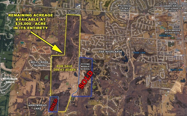
80.41 AC
2025
Columbia/Jefferson City
2025
Other Market Areas
001202
Columbia, MO
NEARBY LISTINGS FOR SALE OR LEASE
DEMOGRAPHICS near S Sinclair Rd
1 mile
3 mile
5 mile
2025 Total Population
4,238
41,934
103,968
2030 Population
4,354
43,375
107,839
Pop Growth 2025-2030
+ 2.74%
+ 3.44%
+ 3.72%
Average Age
40
38
35
2025 Total Households
1,529
17,069
41,689
HH Growth 2025-2030
+ 2.94%
+ 3.60%
+ 4.05%
Median Household Inc
$136,328
$96,793
$63,547
Avg Household Size
2.70
2.40
2.20
2025 Avg HH Vehicles
2.00
2.00
2.00
Median Home Value
$446,698
$379,923
$327,106
Median Year Built
1996
1993
1991
Nearby Places
Map Layers
Map Styles
 Street
 Aerial
Layers
 Traffic
 Biking
Places
Listings with unknown addresses are not visible on the map
- Restaurants
- Banks
- Shops
- Fitness
- Groceries
PUBLIC TRANSPORTATION
AIRPORT
Columbia Regional
Drive
Walk
Distance
Columbia Regional
21 min
13.7 mi
Freight Ports
Tulsa Port of Inola
Drive
Walk
Distance
Tulsa Port of Inola
382 min
336.3 mi
SALE & LEASE HISTORY
LISTING DATE
SALE/LEASE

May 02, 2018
For Sale
Nearby Properties
Address
Land Use
TOTAL SIZE
Lot Size
Zoning
Address
Land Use
TOTAL SIZE
Lot Size
Zoning
373,370 SF
77.30 AC
O1
Address
Land Use
TOTAL SIZE
Lot Size
Zoning
185,585 SF
18.57 AC
Address
Land Use
TOTAL SIZE
Lot Size
Zoning
24,624 SF
21.42 AC
Address
Land Use
TOTAL SIZE
Lot Size
Zoning
34,357 SF
15.59 AC
Address
Land Use
TOTAL SIZE
Lot Size
Zoning
136,851 SF
2.23 AC
CP
Address
Land Use
TOTAL SIZE
Lot Size
Zoning
2,922 SF
11.40 AC
PUD1
Address
Land Use
TOTAL SIZE
Lot Size
Zoning
91,249 SF
11.66 AC
Address
Land Use
TOTAL SIZE
Lot Size
Zoning
159,984 SF
15.20 AC
R3
Address
Land Use
TOTAL SIZE
Lot Size
Zoning
31,200 SF
14.84 AC
Address
Land Use
TOTAL SIZE
Lot Size
Zoning
77,804 SF
7.77 AC
Address
Land Use
TOTAL SIZE
Lot Size
Zoning
83,119 SF
6.48 AC
C1
Address
Land Use
TOTAL SIZE
Lot Size
Zoning
5,920 SF
8.91 AC
R3
Address
Land Use
TOTAL SIZE
Lot Size
Zoning
96,322 SF
9.40 AC
Address
Land Use
TOTAL SIZE
Lot Size
Zoning
57,738 SF
6.61 AC
C1
Address
Land Use
TOTAL SIZE
Lot Size
Zoning
175,980 SF
18.01 AC
R3
Address
Land Use
TOTAL SIZE
Lot Size
Zoning
2,020 SF
8.21 AC
Address
Land Use
TOTAL SIZE
Lot Size
Zoning
64,533 SF
9.35 AC
C3
Address
Land Use
TOTAL SIZE
Lot Size
Zoning
6,415 SF
6.03 AC
C1
Address
Land Use
TOTAL SIZE
Lot Size
Zoning
25,960 SF
5.32 AC
R3
Address
Land Use
TOTAL SIZE
Lot Size
Zoning
3,170 SF
10.90 AC
R3
Address
Land Use
TOTAL SIZE
Lot Size
Zoning
41,052 SF
2.06 AC
CP
Address
Land Use
TOTAL SIZE
Lot Size
Zoning
6,000 SF
10.95 AC
R3
Address
Land Use
TOTAL SIZE
Lot Size
Zoning
46,273 SF
3.28 AC
CP
Address
Land Use
TOTAL SIZE
Lot Size
Zoning
52,651 SF
3.88 AC
C1
Address
Land Use
TOTAL SIZE
Lot Size
Zoning
46,348 SF
4.01 AC
C3C1
Address
Land Use
TOTAL SIZE
Lot Size
Zoning
26,640 SF
19.78 AC
CP
Address
Land Use
TOTAL SIZE
Lot Size
Zoning
43,554 SF
2.40 AC
C1
Address
Land Use
TOTAL SIZE
Lot Size
Zoning
71,311 SF
4.91 AC
C3
Address
Land Use
TOTAL SIZE
Lot Size
Zoning
33,558 SF
12.75 AC
C3
Address
Land Use
TOTAL SIZE
Lot Size
Zoning
26,515 SF
4.81 AC
O1
The World's #1 Commercial Real Estate Marketplace
Connect with us
© 2026 CoStar Group
The information above has been obtained from sources believed reliable. While we do not doubt its accuracy we have not verified it and make no guarantee, warranty or representation about it. It is your responsibility to independently confirm its accuracy and completeness. Any projections, opinions, assumptions, or estimates used are for example only and do not represent the current or future performance of the property. The value of this transaction to you depends on tax and other factors which should be evaluated by your tax, financial, and legal advisors. You and your advisors should conduct a careful, independent investigation of the property to determine to your satisfaction the suitability of the property for your needs.